Old Maps of Gosnold, Massachusetts
Explore 94 old maps of Gosnold, spanning from 1885 to today. These high-resolution historic maps reveal how streets, neighborhoods, landmarks, and natural features evolved over time — perfect for genealogy, metal detecting, research, and local history exploration.
What you can do with these maps:
- See how Gosnold changed over time: Compare historical maps to modern-day views to trace roads, homesites, rail lines & more.
- View detailed metadata: Each map includes creators, publishers, year, scale, and archive source.
- Overlay maps with satellite & LiDAR: Visualize the past alongside modern tools to explore terrain & human change.
- Trusted historical sources: Maps sourced from the USGS, Library of Congress, and other archives.
- Access maps your way: View online, download high-res files, or order prints for personal or research use.
Start exploring old maps of Gosnold to uncover forgotten places, hidden landmarks, and the deep history beneath your feet.
Gosnold, MA maps
(94)- 1885 Map of New Bedford
 1885 New Bedford1885 Print · USGSThe Buzzards Bay coastline and its industrial hubs are captured here as the maritime economy met the rising age of rail. Genealogy and local history researchers can trace the streets of New Bedford, the tracks of the Old Colony Railroad, and coastal landmarks like Clark Point Light.
 - 1885 Map of Sakonnet
 1885 Sakonnet1885 Print · USGSThe Rhode Island coast south of Little Compton and Middletown is captured here in the late nineteenth century, showing a shoreline defined by points and coastal ponds. Researchers can trace landforms and landmarks like Sakonnet Point, Woods Castle, and Sachuest Neck.
 - 1886 Map of Falmouth
 1886 Falmouth1886 Print · USGSThe Cape Cod peninsula during the late nineteenth century shows a landscape transitioning between maritime tradition and rail-driven growth. Genealogists can trace family footprints in Waquoit Village, Teaticket, and Menauhant while following the Old Colony Railroad corridor.
 - 1887 Map of Gay Head
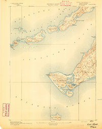
 1887 Gay Head1887 Print · USGSThe islands of Dukes County appear in their late nineteenth-century character, spanning from the heights of Chilmark to the chain of the Elizabeth Islands. Genealogists and historians can trace family-named sites and coastal landmarks like Gay Head Light, the settlement of Squibnocket, and Tarpaulin Cove.
 - 1887 Map of Marthas Vineyard
 1887 Marthas Vineyard1887 Print · USGSMartha's Vineyard in the late nineteenth century remains a landscape of maritime commerce and quiet island life. Genealogists can trace family names and early settlements from Cottage City and Edgartown to the rural roads of West Tisbury.
 - 1888 Map of New Bedford
 1888 New Bedford1888 Print · USGSThe bustling whale oil and textile hub of New Bedford is shown here at its maritime peak in the late nineteenth century. Genealogists can trace early neighborhood grids and find outlying rural stops like Braleys Station, Turners Mills, and Nasketucket.
 - 1888 Map of Falmouth
 1888 Falmouth1888 Print · USGSThe Buzzards Bay coastline and upper Cape Cod are captured here in the late nineteenth century, documenting the critical arrival of the railroad. Researchers can trace the Old Colony Railroad to its terminus at Woods Holl or locate maritime landmarks like Wing's Neck Light.
 - 1888 Map of Sakonnet
 1888 Sakonnet1888 Print · USGSCoastal Rhode Island in the 1880s was defined by its weather-beaten points and maritime outposts. Genealogists and historians can trace the early topography of Little Compton and Middletown, from Sakonnet Point to Woods Castle.
 - 1889 Map of Gay Head
 1889 Gay Head1889 Print · USGSThe western end of Martha's Vineyard and the Elizabeth Islands appear here in the late nineteenth century, defined by a maritime economy of lighthouses and small coastal settlements. Researchers can trace historic landmarks like Gay Head Light, Chilmark, and the remote No Mans Land.
 - 1889 Map of Marthas Vineyard
 1889 Marthas Vineyard1889 Print · USGSThe eastern shores of the Vineyard come alive in the late Victorian era, showcasing the early growth of Cottage City and Edgartown. Genealogists and historians can trace old road networks connecting West Tisbury to the coast and locate historic beacons like West Chop Light.
 - 1893 Map of Gay Head
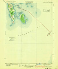
 1893 Gay Head1893 Print · USGSThe islands of Marthas Vineyard and the Elizabeth Islands appear here in the late nineteenth century. Researchers can trace the coastal geography of Chilmark, the prominent Gay Head Light, and the isolated reaches of Cuttyhunk Island and No Mans Land.7 unique versions available
 - 1893 Map of Sakonnet
 1893 Sakonnet1893 Print · USGSThe Rhode Island coast in the late nineteenth century is documented here as a maritime landscape of rocky points and tidal ponds. Researchers can trace the early harbor works at Sakonnet Point or locate family landmarks like Woods Castle and Warren Point.6 unique versions available
 - 1893 Map of Falmouth
 1893 Falmouth1893 Print · USGSCape Cod's western shore and the upper reaches of Buzzards Bay are captured here in the late nineteenth century as rail travel transformed the coast. Genealogists can trace family names at Waquoit Village or follow the Old Colony Railroad through Woods Holl and Falmouth Station.9 unique versions available
 - 1893 Map of New Bedford
 1893 New Bedford1893 Print · USGSThe South Coast of Massachusetts is captured here in the late nineteenth century as a hub of maritime trade and rail transit. Researchers can trace the waterfront development of New Bedford, find old coastal lights like Neds Point Light, and locate family settlements at Potomska and Apponagansett.9 unique versions available
 - 1894 Map of Marthas Vineyard, 1898 Print
 1894 Marthas Vineyard1898 Print · USGSMartha's Vineyard in the 1890s appears as a land of maritime necessity and early coastal villages. Genealogists can trace family settlements in Vineyard Haven and Edgartown or locate lighthouses like West Chop Light and Cape Poge Light.7 unique versions available
 - 1915 Map of Falmouth, 1943 Print
 1915 Falmouth1943 Print · USGSUpper Cape Cod during the mid-forties reveals a landscape of growing military activity alongside traditional coastal villages. Genealogists and historians can trace the foundations of Camp Edwards and find historic post offices at Waquoit Village or Monument Beach.
 - 1918 Map of New Bedford, 1921 Print
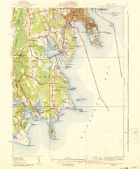
 1918 New Bedford1921 Print · USGSThe Buzzards Bay coastline thrived with rail and maritime commerce during the early twentieth century. Researchers can trace historic shorelines and infrastructure at New Bedford, Fairhaven, and Clark Point Light.
 - 1920 Map of Falmouth
 1920 Falmouth1920 Print · USGSCoastal Barnstable County comes to life in this post-war military survey of the Falmouth peninsula and its maritime approaches. Researchers can trace the Old Colony RR to Falmouth Station or locate landmarks like Nobska Point Light and Waquoit Village.
 - 1936 Map of South Dartmouth
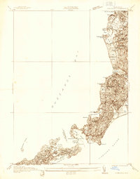
 1936 South Dartmouth1936 Print · USGSCoastal Bristol County is captured here in the mid-1930s, showing a landscape defined by maritime navigation and harbor defenses. Researchers can trace early aviation at the Round Hill Landing Field and locate family landmarks like Crapo Sch or the Rural Cemetery.
 - 1936 Map of Woods Hole
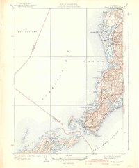
 1936 Woods Hole1936 Print · USGSThe Elizabeth Islands and the Falmouth coast are captured here in the mid-1930s, showing the maritime heart of Cape Cod before modern development. Researchers can trace historic properties at Penzance Pt, the grounds of the Falmouth Country Club, and the intricate shoreline of Naushon Island.
 - 1940 Map of Sconticut Neck
 1940 Sconticut Neck1940 Print · USGSCoastal Fairhaven and its surrounding islands appear here in the mid-1930s, showing the early layout of the peninsula and its maritime borders. Trace the path of Sconticut Neck Road to the tip at Sconticut Point or explore the shores of West Island.3 unique versions available
 - 1941 Map of Woods Hole
 1941 Woods Hole1941 Print · USGSThe Buzzards Bay shoreline and the Elizabeth Islands appear here just before the mid-century, featuring a landscape of maritime industry and coastal estates. Researchers can trace the New York New Haven and Hartford rail line, locate family plots at Crowell Cem, or explore the marshes of Great Sippowisset Swamp.3 unique versions available
 - 1941 Map of New Bedford South
 1941 New Bedford South1941 Print · USGSCoastal Massachusetts at the start of the 1940s reveals a landscape of harbor defenses, seaside villages, and rural schools. Researchers can trace historic family-named landmarks and institutions like Fort Phoenix, St Johns Ch, and the Padanaram Breakwater.3 unique versions available
 - 1942 Map of Newport
 1942 Newport1942 Print · USGSThe Rhode Island coast appears here at a critical wartime moment, showing the heavy fortification of Narragansett Bay. Researchers can trace military sites like Fort Kearny, maritime landmarks like the Point Judith Life Saving Station, and old ferry routes.2 unique versions available
 - 1942 Map of Marthas Vineyard
 1942 Marthas Vineyard1942 Print · USGSMartha's Vineyard and the Elizabeth Islands appear here during the early years of the second World War. Researchers can trace historical lighthouse locations like Gay Head LH and Tarpaulin Cove LH, and explore the 1940s boundaries of Edgartown and Vineyard Haven.
Showing maps 1-25 of 94
Top cities near Gosnold
- New Bedford historical maps
- Fall River historical maps
- Dartmouth historical maps
- Falmouth historical maps
- Bourne historical maps
- Fairhaven historical maps
See more
Top neighborhoods of Gosnold
Frequently asked questions
- What are the different types of historical maps available for Gosnold?
- What is the oldest map of Gosnold?
- Where can I purchase historical maps of Gosnold for my home or office?
- Where can I download high-res historical maps of Gosnold?
- Are there historical topographic maps available for Gosnold?
- Is there historical aerial imagery available for Gosnold?
- Where are historical maps of Gosnold sourced from?