1940s Maps of Rowe, Massachusetts
Explore 5 historic maps of Rowe from the 1940s. These maps offer a rare glimpse into what life looked like during the 1940s — showing old roads, neighborhoods, homes, and landmarks that have changed or disappeared over time.
Whether you're researching your family's past, planning a metal detecting trip, or studying how Rowe's landscape evolved across the 1940s, these high-resolution maps are a powerful tool for exploring the history of this region.
- Focus on a specific era: All maps on this page are from the 1940s, giving you a focused view of this time period.
- See what’s changed: Compare century-old streets, trails, and buildings to today's modern landscape using overlays and satellite layers.
- Research with precision: Use these maps for genealogy, historical research, land use analysis, or educational projects.
- View, download, or print: Maps are fully viewable online in high resolution, and can be downloaded or printed for your own records.
Start exploring Rowe's history through authentic maps from the 1940s. This is your window into the past.
Rowe, MA maps
(5)- 1943 Map of Brattleboro
 1943 Brattleboro1943 Print · USGSSouthern Vermont and the Massachusetts border area appear in this mid-century survey as a landscape of timbered peaks and river-connected villages. Genealogists can trace family roots through markers like Arms Cem or follow the rails at Dummerston Sta and Putney Sta.
 - 1944 Map of Rowe, 1958 Print
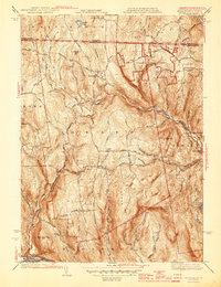
 1944 Rowe1958 Print · USGSThe Deerfield River valley and the Berkshire highlands come alive in this mid-century survey of the Massachusetts-Vermont border. Researchers can trace the path of the Hoosac Tunnel, the Mohawk Trail, and rural cemeteries like Sherman Cem and West Cem.
 - 1945 Map of Heath
 1945 Heath1945 Print · USGSFranklin County's high country is captured here in the mid-1940s, showing a network of upland farms and mountain settlements along the Vermont border. Researchers can trace ancestral roots through sites like Maple Grove Cem, locate the Davis Mine, or follow the winding West Branch North River.3 unique versions available
 - 1947 Map of Rowe
 1947 Rowe1947 Print · USGSFranklin County in the late 1940s reveals a mountainous landscape defined by the engineering of the Hoosac Tunnel and the Deerfield River. Genealogists and historians can locate family plots at North Cem, trace the operations at Davis Mine, and explore the rail-dependent community at Monroe Bridge.2 unique versions available
 - 1948 Map of Albany, 1951 Print
 1948 Albany1951 Print · USGSThe Hudson and Connecticut River valleys are captured here in the late 1940s, showing the vital rail and water corridors of the Northeast. You can trace the Boston and Maine tracks past Mt Greylock or locate early settlements like Great Barrington and Bennington.
End of results
Showing maps 1-5 of 5
Top cities near Rowe
- North Adams historical maps
- Bennington historical maps
- Adams historical maps
- Dalton historical maps
- Pownal historical maps
- Cheshire historical maps
See more
Top neighborhoods of Rowe
Frequently asked questions
- What are the different types of historical maps available for Rowe?
- What is the oldest map of Rowe?
- Where can I purchase historical maps of Rowe for my home or office?
- Where can I download high-res historical maps of Rowe?
- Are there historical topographic maps available for Rowe?
- Is there historical aerial imagery available for Rowe?
- Where are historical maps of Rowe sourced from?