1970s Maps of Shutesbury, Massachusetts
Explore 6 historic maps of Shutesbury from the 1970s. These maps offer a rare glimpse into what life looked like during the 1970s — showing old roads, neighborhoods, homes, and landmarks that have changed or disappeared over time.
Whether you're researching your family's past, planning a metal detecting trip, or studying how Shutesbury's landscape evolved across the 1970s, these high-resolution maps are a powerful tool for exploring the history of this region.
- Focus on a specific era: All maps on this page are from the 1970s, giving you a focused view of this time period.
- See what’s changed: Compare century-old streets, trails, and buildings to today's modern landscape using overlays and satellite layers.
- Research with precision: Use these maps for genealogy, historical research, land use analysis, or educational projects.
- View, download, or print: Maps are fully viewable online in high resolution, and can be downloaded or printed for your own records.
Start exploring Shutesbury's history through authentic maps from the 1970s. This is your window into the past.
Shutesbury, MA maps
(6)- 1975 Map of Orange, 1981 Print
 1975 Orange1981 Print · USGSFranklin County's industrial and rural landscape is seen from above in the mid-seventies, centered on the river-front town of Orange. Researchers can trace the layout of Orange, the northern reaches of the Quabbin Reservoir, and the airfield at The Plains.
 - 1975 Map of Millers Falls, 1981 Print
 1975 Millers Falls1981 Print · USGSFranklin County in the mid-seventies is captured here through detailed aerial imagery showing the river-valley settlements of the Connecticut and Millers rivers. Researchers can trace the layout of villages like Millers Falls, Farley, and Locks Village.
 - 1975 Map of Shutesbury, 1981 Print
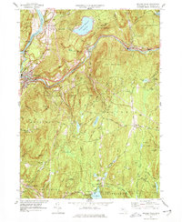
 1975 Shutesbury1981 Print · USGSFranklin County's wooded highlands and the massive Quabbin Reservoir are shown in this mid-1970s aerial survey. Researchers can trace the roads and homesteads of Shutesbury, Locks Village, and Pelham as they sat in the landscape nearly fifty years ago.
 - 1975 Map of Quabbin Reservoir, 1981 Print
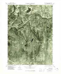
 1975 Quabbin Reservoir1981 Print · USGSIn the mid-1970s, the flooded landscapes of the Swift River Valley were managed as a vital water resource. Modern researchers can trace the shorelines near old settlements like North Prescott and Cooleyville or locate landmarks such as Mount L.
 - 1977 Map of Millers Falls
 1977 Millers Falls1977 Print · USGSFranklin County's rail-and-river network is on full display in the 1970s, from the industrial confluence at Millers Falls to the heights of Northfield Mountain Reservoir. Genealogists and hikers can trace old routes to Field Cem, the community at Northfield Farms, and landmarks like Monks Cave.2 unique versions available
 - 1977 Map of Orange, 1978 Print
 1977 Orange1978 Print · USGSThe Millers River valley in the 1970s shows a landscape of dense state forests and small railroad hamlets. Researchers can trace family sites from Wendell Depot to South Athol, including the Village Ch and the waters of Lake Mattawa.
End of results
Showing maps 1-6 of 6
Top cities near Shutesbury
- Holyoke historical maps
- Amherst historical maps
- Northampton historical maps
- Greenfield historical maps
- South Hadley historical maps
- Easthampton historical maps
See more
Top neighborhoods of Shutesbury
- Baconville historical maps
- Pratt Corner historical maps
- Locks Village historical maps
- Sirius Community historical maps
Frequently asked questions
- What are the different types of historical maps available for Shutesbury?
- What is the oldest map of Shutesbury?
- Where can I purchase historical maps of Shutesbury for my home or office?
- Where can I download high-res historical maps of Shutesbury?
- Are there historical topographic maps available for Shutesbury?
- Is there historical aerial imagery available for Shutesbury?
- Where are historical maps of Shutesbury sourced from?