1940s Maps of Hampden County, Massachusetts
Explore 40 historic maps of Hampden County from the 1940s. These maps offer a rare glimpse into what life looked like during the 1940s — showing old roads, neighborhoods, homes, and landmarks that have changed or disappeared over time.
Whether you're researching your family's past, planning a metal detecting trip, or studying how Hampden County's landscape evolved across the 1940s, these high-resolution maps are a powerful tool for exploring the history of this region.
- Focus on a specific era: All maps on this page are from the 1940s, giving you a focused view of this time period.
- See what’s changed: Compare century-old streets, trails, and buildings to today's modern landscape using overlays and satellite layers.
- Research with precision: Use these maps for genealogy, historical research, land use analysis, or educational projects.
- View, download, or print: Maps are fully viewable online in high resolution, and can be downloaded or printed for your own records.
Start exploring Hampden County's history through authentic maps from the 1940s. This is your window into the past.
Hampden County, MA maps
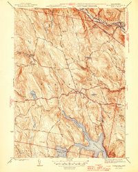
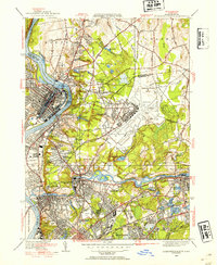
(40)- 1940 Map of Hampden
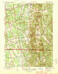
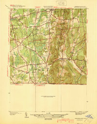 1940 Hampden1940 Print · USGSMassachusetts and Connecticut borderlands meet at the edge of the Berkshires in the late thirties. Local historians can trace old homesteads and community hubs near Baptist Village, Woodland Dell Cem, and the high peak of Minnechoag Mountain.2 unique versions available
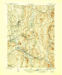
 - 1941 Map of Mt Holyoke
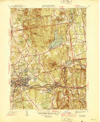
 1941 Mt Holyoke1941 Print · USGSHampshire County thrives along the Connecticut River in the years before the Second World War. Researchers can trace the early footprints of Amherst College, locate family sites at Smiths Ferry, or find small rural centers like Moody Corner and Aldrich Mills.3 unique versions available
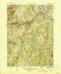
 - 1942 Map of Ludlow
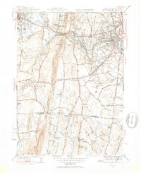
 1942 Ludlow1942 Print · USGSHampden County landscapes in the late thirties reveal a mix of industrial river towns and upland reservoirs. Genealogists can trace family footprints through the Wilbraham Academy, East Wilbraham Cem, and the neighborhoods around Indian Orchard.
 - 1942 Map of Hampden
 1942 Hampden1942 Print · USGSThe Pioneer Valley foothills are captured here in the years before the war, showing the rural character of Hampden and Wilbraham. Genealogists and historians can locate family-named sites such as Adams Cem, Baptist Village, and the Stony Hill Sch.
 - 1942 Map of Southwick
 1942 Southwick1942 Print · USGSSouthwick and the surrounding hill towns are shown here just before the mid-century, where the rail line still hugged the edge of the Congamond Lakes. Researchers can trace old family sites and local industry, from the Southwick Ch to a small Tannery and the West Parish Filters.2 unique versions available
 - 1942 Map of Ware
 1942 Ware1942 Print · USGSCentral Massachusetts and the Connecticut border are captured here during the early years of the war, just as the landscape was being reshaped by the Quabbin Reservoir. Researchers can trace rail-era industry and local landmarks like the Lead Mine and the Bald Peak Hospital.
 - 1942 Map of Woronoco
 1942 Woronoco1942 Print · USGSThe Berkshires meet industrial river valleys in the early 1940s, where the railroad and river define local life. Trace historic marble extraction at the Marble Quarries or find family roots at Clarks Cem and settlements like Woronoco Heights.2 unique versions available
 - 1943 Map of Brookfield
 1943 Brookfield1943 Print · USGSCentral Massachusetts at the height of the war era shows a landscape of busy rail towns and upland ponds. Genealogists and historians can trace family-named peaks like Coys Hill and old industry along the Boston and Albany RR or near Southbridge.
 - 1943 Map of Holyoke
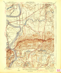
 1943 Holyoke1943 Print · USGSThe Pioneer Valley and the eastern Berkshires are captured here in the early 1940s, showing a robust network of river-side industry and hill-country forests. Researchers can locate vanished landmarks and institutional grounds like Northampton State Hospital, Barnes Airport, and the Nat Gd Rifle Range.
 - 1943 Map of Housatonic
 1943 Housatonic1943 Print · USGSThe Berkshires and the Housatonic Valley are captured during the war years, showing a landscape of traditional Shaker settlements and growing industrial centers. Trace the routes of the NY NH & H RR and explore sites like Shaker Village, Richmond Furnace, and Rockdale Mills.
 - 1944 Map of Hampden
 1944 Hampden1944 Print · USGSThe Massachusetts-Connecticut borderlands come to life in the 1940s, showing the early suburban growth around Sixteen Acres and Hampden. Genealogists can locate family landmarks like Adams Cem, Wilbraham Academy, and the village of Baptist Village.4 unique versions available
 - 1944 Map of Ludlow
 1944 Ludlow1944 Print · USGSHampden County’s industrial river valley and rolling hills are captured here just after the war. Researchers can trace historic family connections through Wilbraham Academy, Hillcrest Park Cem, and the rail lines serving North Wilbraham.3 unique versions available
 - 1944 Map of West Springfield, 1954 Print
 1944 West Springfield1954 Print · USGSThe Pioneer Valley south of Westfield and West Springfield is shown here during the mid-forties, capturing the intersection of industrial rail lines and rural hamlets. Local historians can trace old property boundaries near St James Ch, the Paucatuck Cem, and crossroads like Hosmer Corner.5 unique versions available
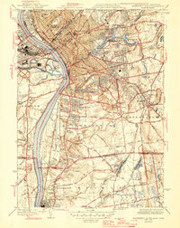
 - 1944 Map of Springfield South, 1954 Print
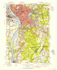 1944 Springfield South1954 Print · USGSGreater Springfield and the lower Connecticut River valley are captured here in the mid-1940s, showing a robust mix of industrial city centers and expanding southern suburbs. Trace local history through landmarks like the US Armory, the Osborn Prison Farm, and the historic Winchester Square.4 unique versions available
 - 1945 Map of West Springfield
 1945 West Springfield1945 Print · USGSThe Westfield River valley during the 1940s reveals a mix of industrial riverfront and rising upland ridges along the Connecticut border. Researchers can trace family history through local landmarks like Kings Cem, the Hastings Hill Sch, and old intersections at Hosmer Corner.2 unique versions available
 - 1945 Map of Becket, 1958 Print
 1945 Becket1958 Print · USGSThe Berkshire highlands come alive in this post-war study of the river-and-rail corridor. Genealogists and historians can trace the path of the Boston & Albany RR through settlements like Bancroft or locate family sites near Becket Center and the Washington Cem.
 - 1946 Map of Blandford
 1946 Blandford1946 Print · USGSBlandford and Huntington are captured here in the mid-1940s, a period defined by the expansion of reservoirs and old mountain turnpikes. Researchers can trace the General Knox Trail, locate the North Blandford Cem, and study the industrial rail lines of the Boston and Albany RR.2 unique versions available
 - 1946 Map of West Granville
 1946 West Granville1946 Print · USGSThe Massachusetts-Connecticut borderlands are captured here in the mid-1940s as the regional landscape was being reshaped by large-scale water projects. Genealogists and local historians can trace family-named roads and landmarks like Tolland Cem, Hartland Sch, and the Booth Hill Fire Tower.2 unique versions available
 - 1946 Map of Palmer
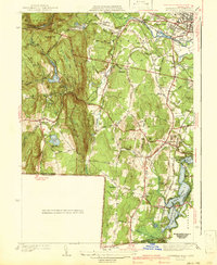
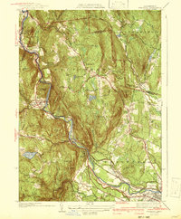
 1946 Palmer1946 Print · USGSHampden County in the mid-1940s is defined by a dense network of river-driven industrial villages and major rail junctions. Researchers can trace the busy corridors of the Boston and Albany RR through the village of Three Rivers or locate the State Fish Hatchery and Landing Field.4 unique versions available
 - 1946 Map of Wales
 1946 Wales1946 Print · USGSThe Massachusetts-Connecticut borderlands are detailed here in the mid-1940s, showing the rural character of the southern New England uplands. Researchers can trace historic settlements like Wales and Mashapaug alongside landmarks such as St Anns Cem and the expansive Hamilton Reservoir.
 - 1946 Map of Warren
 1946 Warren1946 Print · USGSMid-century Worcester County comes to life along the Quaboag River valley just after the war. Local historians can trace the industrial corridor of the Boston and Albany RR through West Warren and locate landmarks like St Marys Cem or Schoolhouse No 4.3 unique versions available
 - 1946 Map of Springfield South
 1946 Springfield South1946 Print · USGSThe Connecticut River valley thrives in the mid-1940s, transitioning from the industrial bustle of Springfield to the emerging suburbs of Longmeadow and Enfield. Genealogists and historians can trace institutional landmarks like the U S Armory, St Michaels Cemetery, and the Osborn Prison Farm.2 unique versions available
 - 1946 Map of Monson
 1946 Monson1946 Print · USGSMonson and the Massachusetts-Connecticut borderland are shown here at the close of the Second World War. Genealogists and local historians can trace the Central Vermont rail line through South Monson, locate the Butler Cem, or find the site of the Brimfield CCC Camp.
 - 1946 Map of Springfield North, 1954 Print
 1946 Springfield North1954 Print · USGSThe Pioneer Valley underwent significant industrial and military growth in the mid-1940s as urbanization reached outward from the riverbanks. Researchers can trace the development of Westover Field or locate family sites near St Aloysius Cem and St Stanislaus Ch.3 unique versions available
 - 1946 Map of Hampden, 1956 Print
 1946 Hampden1956 Print · USGSThe Massachusetts-Connecticut borderlands appear here in the mid-forties, showing a mix of established academy towns and expanding residential pockets. Trace the historical roots of Baptist Village, locate the grounds of Wilbraham Academy, or find the secluded Glendale Ch among the eastern hills.
Showing maps 1-25 of 40
Top cities of Hampden County
- Springfield historical maps
- Chicopee historical maps
- Westfield historical maps
- Holyoke historical maps
- Agawam historical maps
- West Springfield historical maps
See more
Frequently asked questions
- What are the different types of historical maps available for Hampden County?
- What is the oldest map of Hampden County?
- Where can I purchase historical maps of Hampden County for my home or office?
- Where can I download high-res historical maps of Hampden County?
- Are there historical topographic maps available for Hampden County?
- Is there historical aerial imagery available for Hampden County?
- Where are historical maps of Hampden County sourced from?