1960s Maps of Brimfield, Massachusetts
Explore 5 historic maps of Brimfield from the 1960s. These maps offer a rare glimpse into what life looked like during the 1960s — showing old roads, neighborhoods, homes, and landmarks that have changed or disappeared over time.
Whether you're researching your family's past, planning a metal detecting trip, or studying how Brimfield's landscape evolved across the 1960s, these high-resolution maps are a powerful tool for exploring the history of this region.
- Focus on a specific era: All maps on this page are from the 1960s, giving you a focused view of this time period.
- See what’s changed: Compare century-old streets, trails, and buildings to today's modern landscape using overlays and satellite layers.
- Research with precision: Use these maps for genealogy, historical research, land use analysis, or educational projects.
- View, download, or print: Maps are fully viewable online in high resolution, and can be downloaded or printed for your own records.
Start exploring Brimfield's history through authentic maps from the 1960s. This is your window into the past.
Brimfield, MA maps
(5)- 1962 Map of Albany
 1962 Albany1962 Print · USGSThe Hudson and Connecticut River valleys meet the Green Mountains and Berkshires in this mid-century overview of the Northeast. Genealogists and historians can trace the industrial hearts of Albany and Springfield or locate features like Quabbin Reservoir and Westover Air Force Base.
 - 1967 Map of Monson, 1969 Print
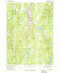 1967 Monson1969 Print · USGSAcross the Massachusetts-Connecticut line in the 1960s, this area shows a landscape of deep forests and narrow rail-side valleys. Researchers can locate family landmarks like Hillside Cem, trace the Central Vermont tracks, or explore the Staffordville Reservoir shoreline.5 unique versions available
 - 1967 Map of Wales, 1970 Print
 1967 Wales1970 Print · USGSThe Massachusetts-Connecticut borderlands are captured here in the late sixties, showing the sprawling state forests and new reservoirs of the era. Genealogists can trace family names across Haynes Hill and Blake Hill or locate landmarks like the Springfield Boys Camp.5 unique versions available
 - 1969 Map of Palmer, 1972 Print
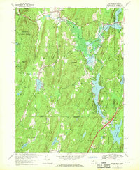
 1969 Palmer1972 Print · USGSThe industrial river valleys of central Massachusetts come to life in this map from the late sixties. Trace the dense rail corridors of the Central Vermont Railroad and find local landmarks like St Anns Cem, the Drive-in Theater, and Wing Memorial Hospital.3 unique versions available
 - 1969 Map of Warren, 1978 Print
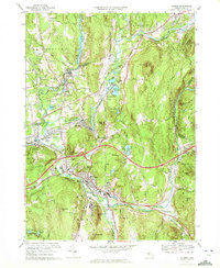
 1969 Warren1978 Print · USGSThe Quaboag River valley in the late sixties reveals a landscape of industrial villages and expanding turnpike infrastructure. Genealogists can locate family sites near Old Warren Cem, St Marys Cem, and landmarks like Steerage Rock.2 unique versions available
End of results
Showing maps 1-5 of 5
Top cities near Brimfield
- Ludlow historical maps
- Southbridge historical maps
- Wilbraham historical maps
- Tolland historical maps
- Belchertown historical maps
- Ellington historical maps
See more
Top neighborhoods of Brimfield
- Dingley Dell historical maps
- Fentonville historical maps
- East Brimfield historical maps
- West Brimfield historical maps
- Little Rest historical maps
Frequently asked questions
- What are the different types of historical maps available for Brimfield?
- What is the oldest map of Brimfield?
- Where can I purchase historical maps of Brimfield for my home or office?
- Where can I download high-res historical maps of Brimfield?
- Are there historical topographic maps available for Brimfield?
- Is there historical aerial imagery available for Brimfield?
- Where are historical maps of Brimfield sourced from?