1930s Maps of Westfield, Massachusetts
Explore 5 historic maps of Westfield from the 1930s. These maps offer a rare glimpse into what life looked like during the 1930s — showing old roads, neighborhoods, homes, and landmarks that have changed or disappeared over time.
Whether you're researching your family's past, planning a metal detecting trip, or studying how Westfield's landscape evolved across the 1930s, these high-resolution maps are a powerful tool for exploring the history of this region.
- Focus on a specific era: All maps on this page are from the 1930s, giving you a focused view of this time period.
- See what’s changed: Compare century-old streets, trails, and buildings to today's modern landscape using overlays and satellite layers.
- Research with precision: Use these maps for genealogy, historical research, land use analysis, or educational projects.
- View, download, or print: Maps are fully viewable online in high resolution, and can be downloaded or printed for your own records.
Start exploring Westfield's history through authentic maps from the 1930s. This is your window into the past.
Westfield, MA maps
(5)- 1933 Map of Feeding Hills
 1933 Feeding Hills1933 Print · USGSThe Lower Pioneer Valley in the early thirties reveals a landscape shaped by the ridge of Proven Mountain and the winding Westfield River. Genealogists and historians can locate legacy institutions like the Westfield State Sanatorium and trace local neighborhoods from Frog Bottom to Feeding Hills.
 - 1937 Map of Southwick
 1937 Southwick1937 Print · USGSHampden County's borderlands are captured in the late 1930s, showing the early infrastructure and rural character of this Massachusetts-Connecticut corridor. Local historians can trace old transit lines like the New York and New Haven Road and identify ancestral sites at Granville Cem or the Northeast Cem.
 - 1937 Map of Woronoco
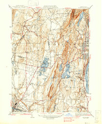
 1937 Woronoco1937 Print · USGSThe Westfield River valley and the hills of Hampden County are shown here as they appeared in the years before World War II. Researchers can trace the path of the Abandoned Canal, explore the Westfield Marble Quarries, or locate family sites near St Thomas Cem and the New State Sch.
 - 1938 Map of Mt Tom
 1938 Mt Tom1938 Print · USGSThe Pioneer Valley underwent significant industrial and recreational growth in the late 1930s as cities like Holyoke and Westfield expanded. Genealogists and local historians can trace family locations near St Jerome Cem, the St Marys Cemetery, or the historic Mountain Park and Barnes Landing Field.6 unique versions available
 - 1938 Map of West Springfield
 1938 West Springfield1938 Print · USGSHampden County's river valleys and ridgelines are captured here in the 1930s during a period of steady institutional and residential growth. Genealogists and local historians can trace the foundations of WESTFIELD and AGAWAM, locating family landmarks like Shea Corner, St James Ch, and the Suffield Street Sch.3 unique versions available
End of results
Showing maps 1-5 of 5
Top cities near Westfield
- Springfield historical maps
- Chicopee historical maps
- Enfield historical maps
- Holyoke historical maps
- Amherst historical maps
- Windsor historical maps
See more
Top neighborhoods of Westfield
- Wyben historical maps
- West Farms historical maps
- Mundale historical maps
- Hampton Ponds historical maps
- Gas Light District historical maps
- Trainfield historical maps
See more
Frequently asked questions
- What are the different types of historical maps available for Westfield?
- What is the oldest map of Westfield?
- Where can I purchase historical maps of Westfield for my home or office?
- Where can I download high-res historical maps of Westfield?
- Are there historical topographic maps available for Westfield?
- Is there historical aerial imagery available for Westfield?
- Where are historical maps of Westfield sourced from?