1800s (19th Century) Maps of Granby, Massachusetts
Explore 17 historic maps of Granby from the 1800s (19th Century). These maps offer a rare glimpse into what life looked like during the 1800s — showing old roads, neighborhoods, homes, and landmarks that have changed or disappeared over time.
Whether you're researching your family's past, planning a metal detecting trip, or studying how Granby's landscape evolved across the 1800s, these high-resolution maps are a powerful tool for exploring the history of this region.
- Focus on a specific era: All maps on this page are from the 1800s, giving you a focused view of this time period.
- See what’s changed: Compare century-old streets, trails, and buildings to today's modern landscape using overlays and satellite layers.
- Research with precision: Use these maps for genealogy, historical research, land use analysis, or educational projects.
- View, download, or print: Maps are fully viewable online in high resolution, and can be downloaded or printed for your own records.
Start exploring Granby's history through authentic maps from the 1800s. This is your window into the past.
Granby, MA maps
(17)- 1885 Map of Northampton
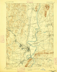
 1885 Northampton1885 Print · USGSThe Pioneer Valley in the late 1800s was a hub of academic and industrial energy centered on the Connecticut River. Genealogists can trace family roots through hamlets like Hockanum and Loudville or locate early campus sites like the Agricultural College.
 - 1886 Map of Springfield
 1886 Springfield1886 Print · USGSThe Connecticut River valley thrives as a rail and industrial powerhouse at the end of the nineteenth century. Genealogists and researchers can trace local families and industry in hubs like Chicopee Falls, Ireland Parish, and the growing streetscapes of Brightwood.
 - 1886 Map of Northampton
 1886 Northampton1886 Print · USGSThe Pioneer Valley in the mid-1880s is captured here at a peak of rail expansion and educational growth. Researchers can trace the early footprints of the Agricultural College, the industrial works at Haydenville, and the landmark Insane Asylum.
 - 1887 Map of Palmer
 1887 Palmer1887 Print · USGSHampden County's industrial river valleys thrive in the late nineteenth century as rail and water power converge. Genealogists and historians can trace the growth of Three Rivers, locate the Alms House near Palmer, and identify old mill sites like Ellis Mills.
 - 1887 Map of Belchertown
 1887 Belchertown1887 Print · USGSThe Swift River valley is shown here in the late 1880s, before the landscape was transformed. Researchers can trace the original rail lines of the Boston & Albany R. R. and locate the lost streets of Enfield, Greenwich, and Prescott.
 - 1889 Map of Springfield
 1889 Springfield1889 Print · USGSThe Connecticut River valley thrives as an industrial powerhouse in the 1880s, fueled by a dense network of water power and rail. Genealogists and historians can trace the foundations of Holyoke and Springfield, or find smaller settlements like Baptist Village and Mittineague.
 - 1889 Map of Palmer
 1889 Palmer1889 Print · USGSHampden County and the surrounding valley are shown here in the 1880s as a thriving hub of rail and water-powered industry. Genealogists and historians can trace the foundations of local commerce through landmarks like Ellis Mills, the State Alms House, and the Granite Quarry.
 - 1890 Map of Belchertown
 1890 Belchertown1890 Print · USGSThe Swift River valley is seen here in the late nineteenth century, long before the creation of the Quabbin Reservoir. Genealogists and local historians can trace the vanished streets of Enfield, Greenwich, and North Dana, or follow the old Boston & Albany R. R. line.
 - 1891 Map of Northampton
 1891 Northampton1891 Print · USGSThe Pioneer Valley in the early nineties shows a landscape of river-driven industry and rising academic centers. Genealogists can trace family roots through old settlements like Bay State Village and Hockanum, or locate early campus sites at the Agricultural College.
 - 1893 Map of Northampton
 1893 Northampton1893 Print · USGSHampshire County in the late nineteenth century is a landscape of thriving mill towns and emerging college campuses. Trace the industrial operations at Factory Hollow or locate old crossings like the Smith Ferry and the Ferry at Hatfield.
 - 1893 Map of Springfield
 1893 Springfield1893 Print · USGSThe Pioneer Valley at the end of the nineteenth century centers on the bustling riverfronts of Springfield and Holyoke. Genealogists and historians can trace the rail-connected neighborhoods of Indian Orchard, the distinct Shakers settlement, and early industries along the Chicopee River.
 - 1893 Map of Palmer
 1893 Palmer1893 Print · USGSHampden County and its surrounding borders are captured here during a peak era of rail expansion and water-powered industry. Researchers can trace the junction of major lines at Barretts Junction or locate vanished industrial hamlets like Duckville and Ellis Mills.9 unique versions available
 - 1893 Map of Belchertown
 1893 Belchertown1893 Print · USGSThe Swift River valley is shown here in the 1890s, years before the landscape was fundamentally altered. Genealogists can trace family homes and rail routes through Enfield, Prescott, North Dana, and the Boston & Albany R R.8 unique versions available
 - 1895 Map of Springfield
 1895 Springfield1895 Print · USGSThe Connecticut River valley thrives in the late 1800s as a powerhouse of rail-side industry and varied agricultural settlements. Researchers can trace the early layouts of Ireland Parish, the Shaker community, and the mills of Chicopee Falls.11 unique versions available
 - 1895 Map of Northampton
 1895 Northampton1895 Print · USGSThe Pioneer Valley is captured here in the late nineteenth century, showing a landscape of burgeoning industrial villages and prestigious colleges. Researchers can trace the early rail networks like the Williamsburg Br. or locate historic sites like the Insane Asylum and Hockanum.10 unique versions available
 - 1896 Map of Holyoke
 1896 Holyoke1896 Print · USGSThe Pioneer Valley and the eastern Berkshire foothills thrive in the 1890s as a complex network of industrial towns and upland farming communities. Historians can trace early infrastructure through the Bisbee Mill, the Agricultural College, and the prominent Ox Bow on the Connecticut River.
 - 1897 Map of Holyoke
 1897 Holyoke1897 Print · USGSThe Pioneer Valley and surrounding highlands thrive in the 1890s, caught here at the height of the region's industrial and agricultural development. Genealogists and historians can trace family roots through dozens of hill towns and river settlements, from Agricultural College in Amherst to the mills of Holyoke and the remote tracks of the Athol Br. R. R..
End of results
Showing maps 1-17 of 17
Top cities near Granby
- Springfield historical maps
- Chicopee historical maps
- Westfield historical maps
- Holyoke historical maps
- Amherst historical maps
- Northampton historical maps
See more
Top neighborhoods of Granby
Frequently asked questions
- What are the different types of historical maps available for Granby?
- What is the oldest map of Granby?
- Where can I purchase historical maps of Granby for my home or office?
- Where can I download high-res historical maps of Granby?
- Are there historical topographic maps available for Granby?
- Is there historical aerial imagery available for Granby?
- Where are historical maps of Granby sourced from?