1970s Maps of Williamsburg, Massachusetts
Explore 6 historic maps of Williamsburg from the 1970s. These maps offer a rare glimpse into what life looked like during the 1970s — showing old roads, neighborhoods, homes, and landmarks that have changed or disappeared over time.
Whether you're researching your family's past, planning a metal detecting trip, or studying how Williamsburg's landscape evolved across the 1970s, these high-resolution maps are a powerful tool for exploring the history of this region.
- Focus on a specific era: All maps on this page are from the 1970s, giving you a focused view of this time period.
- See what’s changed: Compare century-old streets, trails, and buildings to today's modern landscape using overlays and satellite layers.
- Research with precision: Use these maps for genealogy, historical research, land use analysis, or educational projects.
- View, download, or print: Maps are fully viewable online in high resolution, and can be downloaded or printed for your own records.
Start exploring Williamsburg's history through authentic maps from the 1970s. This is your window into the past.
Williamsburg, MA maps
(6)- 1972 Map of Westhampton, 1973 Print
 1972 Westhampton1973 Print · USGSHampshire County highland life and river management are preserved here in the early 1970s. Local researchers can trace family roots through Torrey Cem and Norwich Bridge Cem or locate former industrial sites like Bisbee Mill.2 unique versions available
 - 1972 Map of Goshen, 1973 Print
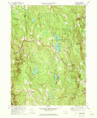 1972 Goshen1973 Print · USGSGoshen and its surrounding highlands appear here in the early 1970s, showcasing a landscape of state forests and summer camps. Genealogists can trace family landmarks like Goshen Cem, Davenport Sch, and the remote Devils Den.4 unique versions available
 - 1975 Map of Westhampton, 1981 Print
 1975 Westhampton1981 Print · USGSHampshire County’s wooded hills and river valleys are captured in mid-1970s aerial detail. Researchers can trace land use around Westhampton and follow the paths of the Westfield River or Pine Island Lake.
 - 1975 Map of Easthampton, 1981 Print
 1975 Easthampton1981 Print · USGSNorthampton and the central Pioneer Valley are documented here in the mid-seventies through detailed aerial photography. Genealogists and local historians can trace the exact 1975 footprints of settlements like Loudville, West Farms, and Easthampton.
 - 1975 Map of Williamsburg, 1981 Print
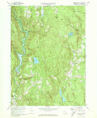
 1975 Williamsburg1981 Print · USGSWilliamsburg and the surrounding hill towns appear in high-altitude detail during the mid-seventies. Local historians can trace the building footprints in Williamsburg, find the residential clusters of Searsville, and follow the course of the Mill River.
 - 1975 Map of Goshen, 1981 Print
 1975 Goshen1981 Print · USGSHampshire County's wooded hills and small villages are shown in high-altitude detail during the mid-seventies. Genealogists and researchers can trace the roads connecting Goshen and Chesterfield past landmarks like Highland Lakes.
End of results
Showing maps 1-6 of 6
Top cities near Williamsburg
- Chicopee historical maps
- Westfield historical maps
- Holyoke historical maps
- Amherst historical maps
- Northampton historical maps
- Ludlow historical maps
See more
Top neighborhoods of Williamsburg
- Searsville historical maps
- Haydenville historical maps
- Williamsburg Center Historic District historical maps
Frequently asked questions
- What are the different types of historical maps available for Williamsburg?
- What is the oldest map of Williamsburg?
- Where can I purchase historical maps of Williamsburg for my home or office?
- Where can I download high-res historical maps of Williamsburg?
- Are there historical topographic maps available for Williamsburg?
- Is there historical aerial imagery available for Williamsburg?
- Where are historical maps of Williamsburg sourced from?