Old Maps of Bradford-Union Street Historic District, Plymouth for Genealogy
Trace your family roots with 18 historic maps of Bradford-Union Street Historic District. These high-res maps reveal old neighborhoods, homesites, landmarks, and streets — helping you uncover where your ancestors lived and how the area evolved over time.
- Explore historic neighborhoods: Identify where your relatives may have lived in the 1800s or 1900s.
- Compare maps over time: Trace the changes in streets, buildings, and landmarks for multi-generational research.
- Perfect for genealogy & ancestry research: Used by family historians and researchers to map out lineage and migration.
These maps are an incredible resource for exploring your personal connection to Bradford-Union Street Historic District's past.
Bradford-Union Street Historic District, Plymouth maps
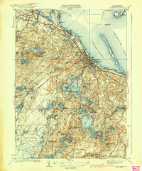
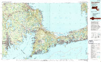
(18)- 1886 Map of Plymouth
 1886 Plymouth1886 Print · USGSCovers Bradford-Union Street Historic District, including Plymouth, Wareham, and other nearby areas
 - 1889 Map of Plymouth
 1889 Plymouth1889 Print · USGSCovers Bradford-Union Street Historic District, including Plymouth, Wareham, and other nearby areas
 - 1894 Map of Plymouth
 1894 Plymouth1894 Print · USGSCovers Bradford-Union Street Historic District, including Plymouth, Wareham, and other nearby areas9 unique versions available
 - 1921 Map of Plymouth
 1921 Plymouth1921 Print · USGSCovers Bradford-Union Street Historic District, including Plymouth, Wareham, and other nearby areas
 - 1934 Map of Plymouth
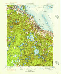
 1934 Plymouth1934 Print · USGSCovers Bradford-Union Street Historic District, including Plymouth, Duxbury, and other nearby areas
 - 1939 Map of Plymouth
 1939 Plymouth1939 Print · USGSCovers Bradford-Union Street Historic District, including Plymouth, Duxbury, and other nearby areas4 unique versions available
 - 1942 Map of New Bedford
 1942 New Bedford1942 Print · USGSCovers Bradford-Union Street Historic District, including New Bedford, Plymouth, and other nearby areas2 unique versions available
 - 1943 Map of Plymouth
 1943 Plymouth1943 Print · USGSCovers Bradford-Union Street Historic District, including Plymouth, Wareham, and other nearby areas
 - 1947 Map of Providence, 1948 Print
 1947 Providence1948 Print · USGSCovers Bradford-Union Street Historic District, including Providence, New Bedford, and other nearby areas5 unique versions available
 - 1948 Map of Providence, 1951 Print
 1948 Providence1951 Print · USGSCovers Bradford-Union Street Historic District, including Providence, New Bedford, and other nearby areas
 - 1950 Map of Plymouth, 1956 Print
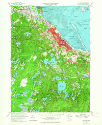
 1950 Plymouth1956 Print · USGSCovers Bradford-Union Street Historic District, including Plymouth, Duxbury, and other nearby areas2 unique versions available
 - 1957 Map of Providence
 1957 Providence1957 Print · USGSCovers Bradford-Union Street Historic District, including Providence, New Bedford, and other nearby areas
 - 1958 Map of Providence
 1958 Providence1958 Print · USGSCovers Bradford-Union Street Historic District, including Providence, New Bedford, and other nearby areas
 - 1962 Map of Plymouth, 1964 Print
 1962 Plymouth1964 Print · USGSCovers Bradford-Union Street Historic District, including Plymouth, Duxbury, and other nearby areas2 unique versions available
 - 1963 Map of Providence
 1963 Providence1963 Print · USGSCovers Bradford-Union Street Historic District, including Providence, New Bedford, and other nearby areas
 - 1977 Map of Plymouth, 1978 Print
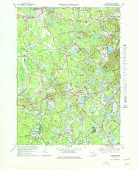 1977 Plymouth1978 Print · USGSCovers Bradford-Union Street Historic District, including Plymouth, Duxbury, and other nearby areas4 unique versions available
 - 1986 Map of New Bedford
 1986 New Bedford1986 Print · USGSCovers Bradford-Union Street Historic District, including New Bedford, Plymouth, and other nearby areas
 - 1994 Map of New Bedford
 1994 New Bedford1994 Print · USGSCovers Bradford-Union Street Historic District, including New Bedford, Plymouth, and other nearby areas
End of results
Showing maps 1-18 of 18
Frequently asked questions
- What are the different types of historical maps available for Bradford-Union Street Historic District?
- What is the oldest map of Bradford-Union Street Historic District?
- Where can I purchase historical maps of Bradford-Union Street Historic District for my home or office?
- Where can I download high-res historical maps of Bradford-Union Street Historic District?
- Are there historical topographic maps available for Bradford-Union Street Historic District?
- Is there historical aerial imagery available for Bradford-Union Street Historic District?
- Where are historical maps of Bradford-Union Street Historic District sourced from?