1970s Maps of Wareham, Massachusetts
Explore 7 historic maps of Wareham from the 1970s. These maps offer a rare glimpse into what life looked like during the 1970s — showing old roads, neighborhoods, homes, and landmarks that have changed or disappeared over time.
Whether you're researching your family's past, planning a metal detecting trip, or studying how Wareham's landscape evolved across the 1970s, these high-resolution maps are a powerful tool for exploring the history of this region.
- Focus on a specific era: All maps on this page are from the 1970s, giving you a focused view of this time period.
- See what’s changed: Compare century-old streets, trails, and buildings to today's modern landscape using overlays and satellite layers.
- Research with precision: Use these maps for genealogy, historical research, land use analysis, or educational projects.
- View, download, or print: Maps are fully viewable online in high resolution, and can be downloaded or printed for your own records.
Start exploring Wareham's history through authentic maps from the 1970s. This is your window into the past.
Wareham, MA maps
(7)- 1972 Map of Wareham, 1974 Print
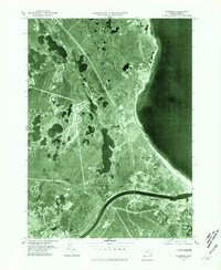
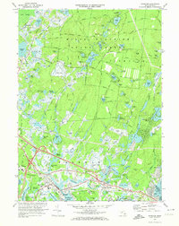 1972 Wareham1974 Print · USGSCoastal Massachusetts in the early seventies shows a balance between sprawling wildlands and the industrial cranberry harvest. Genealogists and historians can trace the town's development through the Penn Central rail corridor and sites like St Patricks Cem and the State Correctional Institution Forestry Camp.3 unique versions available
 - 1977 Map of Snipatuit Pond, 1979 Print
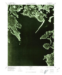
 1977 Snipatuit Pond1979 Print · USGSPlymouth County's cranberry country and wetland heritage are preserved in this mid-seventies survey of the Middleborough and Wareham borderlands. Genealogists and local historians can trace family-named crossroads like Douglas Corner, find old burial sites at Union Cem, and locate the Seaplane Base on the shore of Snipatuit Pond.2 unique versions available
 - 1977 Map of Marion, 1979 Print
 1977 Marion1979 Print · USGSCoastal life in the late seventies is centered on the harbor towns of Marion and Mattapoisett during a period of modern infrastructure expansion. Genealogists and historians can trace family roots through Barlow Cem, the historic Sturtevant Mill, and local schools like Tabor Academy.4 unique versions available
 - 1977 Map of Wareham, 1981 Print
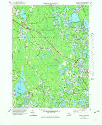
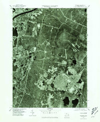
 1977 Wareham1981 Print · USGSSoutheastern Massachusetts enters the late seventies with a blend of traditional cranberry culture and expanding coastal settlements. Trace the river-and-road networks of Wareham and South Carver or locate family properties in Oakdale.
 - 1977 Map of Onset, 1981 Print
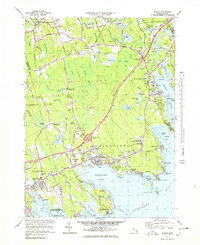
 1977 Onset1981 Print · USGSCoastal Massachusetts at the end of the seventies reveals a detailed look at the developing shorelines and seasonal communities of the Buzzards Bay region. Researchers can trace the layout of waterfront settlements like Onset, Silver Beach, and the residential peninsulas of Great Neck.
 - 1977 Map of Sagamore, 1981 Print
 1977 Sagamore1981 Print · USGSThe eastern gateway to the Cape is captured here in the late 1970s, showcasing the engineering of the Cape Cod Canal and the surrounding coastline. Researchers can trace the development of Sagamore Beach and shoreline settlements like Cedarville.
 - 1977 Map of Pocasset, 1981 Print
 1977 Pocasset1981 Print · USGSCape Cod in the late seventies is seen through this detailed aerial survey of the western shoreline and canal entrance. Researchers can trace the development of Monument Beach and Pocasset or examine the infrastructure around the Cape Cod Canal.
End of results
Showing maps 1-7 of 7
Top cities near Wareham
- New Bedford historical maps
- Plymouth historical maps
- Dartmouth historical maps
- Falmouth historical maps
- Bridgewater historical maps
- Sandwich historical maps
See more
Top neighborhoods of Wareham
- Point Independence historical maps
- Weweantic historical maps
- Jefferson Shores historical maps
- Onset Station historical maps
- South Wareham historical maps
- Tihonet historical maps
See more
Frequently asked questions
- What are the different types of historical maps available for Wareham?
- What is the oldest map of Wareham?
- Where can I purchase historical maps of Wareham for my home or office?
- Where can I download high-res historical maps of Wareham?
- Are there historical topographic maps available for Wareham?
- Is there historical aerial imagery available for Wareham?
- Where are historical maps of Wareham sourced from?