1970s Maps of Wareham Center, Wareham
Explore 2 historic maps of Wareham Center from the 1970s. These maps offer a rare glimpse into what life looked like during the 1970s — showing old roads, neighborhoods, homes, and landmarks that have changed or disappeared over time.
Whether you're researching your family's past, planning a metal detecting trip, or studying how Wareham Center's landscape evolved across the 1970s, these high-resolution maps are a powerful tool for exploring the history of this region.
- Focus on a specific era: All maps on this page are from the 1970s, giving you a focused view of this time period.
- See what’s changed: Compare century-old streets, trails, and buildings to today's modern landscape using overlays and satellite layers.
- Research with precision: Use these maps for genealogy, historical research, land use analysis, or educational projects.
- View, download, or print: Maps are fully viewable online in high resolution, and can be downloaded or printed for your own records.
Start exploring Wareham Center's history through authentic maps from the 1970s. This is your window into the past.
Wareham Center, Wareham maps
(2)- 1972 Map of Wareham, 1974 Print
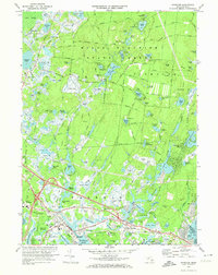 1972 Wareham1974 Print · USGSCoastal Massachusetts in the early seventies shows a balance between sprawling wildlands and the industrial cranberry harvest. Genealogists and historians can trace the town's development through the Penn Central rail corridor and sites like St Patricks Cem and the State Correctional Institution Forestry Camp.3 unique versions available
 - 1977 Map of Wareham, 1981 Print
 1977 Wareham1981 Print · USGSSoutheastern Massachusetts enters the late seventies with a blend of traditional cranberry culture and expanding coastal settlements. Trace the river-and-road networks of Wareham and South Carver or locate family properties in Oakdale.
End of results
Showing maps 1-2 of 2
Top cities near Wareham Center
- New Bedford historical maps
- Plymouth historical maps
- Dartmouth historical maps
- Falmouth historical maps
- Bridgewater historical maps
- Wareham historical maps
See more
Frequently asked questions
- What are the different types of historical maps available for Wareham Center?
- What is the oldest map of Wareham Center?
- Where can I purchase historical maps of Wareham Center for my home or office?
- Where can I download high-res historical maps of Wareham Center?
- Are there historical topographic maps available for Wareham Center?
- Is there historical aerial imagery available for Wareham Center?
- Where are historical maps of Wareham Center sourced from?