Old Maps of Alcona County, Michigan
Explore 113 old maps of Alcona County, spanning from 1954 to today. These high-resolution historic maps reveal how streets, neighborhoods, landmarks, and natural features evolved over time — perfect for genealogy, metal detecting, research, and local history exploration.
What you can do with these maps:
- See how Alcona County changed over time: Compare historical maps to modern-day views to trace roads, homesites, rail lines & more.
- View detailed metadata: Each map includes creators, publishers, year, scale, and archive source.
- Overlay maps with satellite & LiDAR: Visualize the past alongside modern tools to explore terrain & human change.
- Trusted historical sources: Maps sourced from the USGS, Library of Congress, and other archives.
- Access maps your way: View online, download high-res files, or order prints for personal or research use.
Start exploring old maps of Alcona County to uncover forgotten places, hidden landmarks, and the deep history beneath your feet.
Alcona County, MI maps
(113)- 1954 Map of Tawas City, 1968 Print
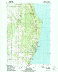
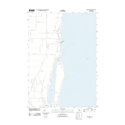
 1954 Tawas City1968 Print · USGSCoastal life along Lake Huron was defined by a mix of military aviation and hydroelectric power in the mid-fifties. Researchers can trace the river dams like Cooke Dam, the layout of Wurtsmith AFB, and the coastal mining operations at Alabaster.4 unique versions available
 - 1958 Map of Tawas City
 1958 Tawas City1958 Print · USGSThe Lake Huron shoreline and northern Michigan timberlands come into focus in the late fifties, during the expansion of the Cold War. Genealogists and historians can trace rail lines like the Detroit and Mackinac, find regional landmarks like the Lumbermans Memorial Monument, and locate coastal facilities including Wurtsmith AFB.2 unique versions available
 - 1959 Map of Glennie, 1961 Print
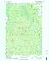
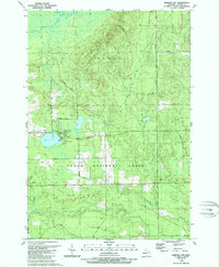
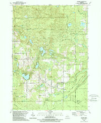
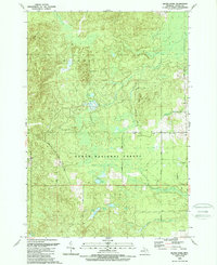
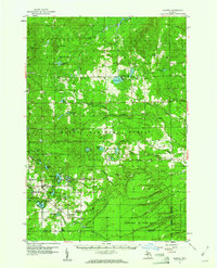 1959 Glennie1961 Print · USGSAlcona County's lake country and timberlands are captured here in the late fifties as military activity and forest management shaped the region. Genealogists and historians can trace the exact locations of Lott Ch, Glennie Cem, and the sprawling Wurtsmith Air Force Range.3 unique versions available
 - 1959 Map of Harrisville, 1961 Print
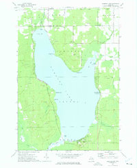
 1959 Harrisville1961 Print · USGSThe Alcona County coast and its timbered interior are captured here at the end of the 1950s as the regional economy balanced forestry and lakefront tourism. Genealogists can trace family names through rural sites like St Annes Cem, Calvary Ch, and the Indian Mission near the Iosco County line.3 unique versions available
 - 1971 Map of Spruce, 1974 Print
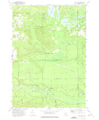
 1971 Spruce1974 Print · USGSAlcona County's transition from timber production to a forested recreational landscape is clear in this early 1970s survey. Genealogists and local historians can trace family roots near Spruce and Township Cem, or follow the Old Railroad Grade past Badger Lake.2 unique versions available
 - 1971 Map of Black River, 1974 Print
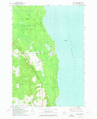 1971 Black River1974 Print · USGSThe Alcona County coastline comes alive in the early 1970s, showcasing the intersection of the Detroit and Mackinac railroad and the Lake Huron shore. Researchers can trace the layout of the Black River settlement, locating family landmarks like the Black River Sch and Calvary Cem.
 - 1972 Map of Hubbard Lake
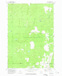
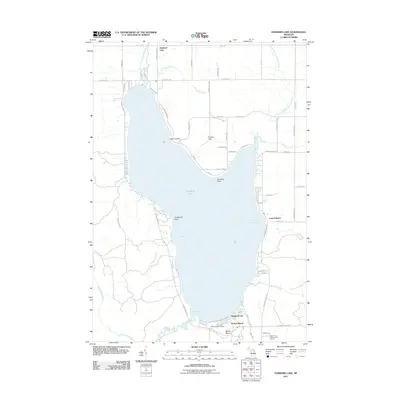
 1972 Hubbard Lake1972 Print · USGSHubbard Lake's expansive shoreline is mapped here in the early seventies, detailing the transition from rural Alcona and Alpena counties to a lakeside community. Researchers can locate local landmarks like the Caledonia Sch, the slopes of Mt Maria, and the docks at Larson Beach.2 unique versions available
 - 1972 Map of McKinley, 1975 Print
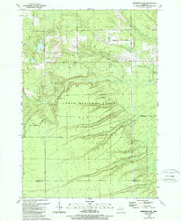
 1972 McKinley1975 Print · USGSOscoda County in the early seventies preserves the landscape of the Huron National Forest and the winding Au Sable River. Researchers can trace the legacy of Michigan logging via the Old Railroad Grade and locate family landmarks at Mc Kinley and Camp Barakel.
 - 1972 Map of Curran, 1975 Print
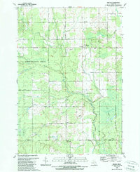
 1972 Curran1975 Print · USGSAlcona County's forested interior is captured here in the early seventies, showing the intersection of logging history and conservation. Researchers can trace the Old Railroad Grade and locate old landmarks like Curran Cem and Hoist Lakes.2 unique versions available
 - 1972 Map of McCollum Lake, 1975 Print
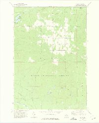
 1972 McCollum Lake1975 Print · USGSNorthern Michigan forest lands are shown in the early seventies at the junction of four counties. Researchers can trace old logging routes along the Old Railroad Grade and locate features like McCollum Lake and the Fonro Lodge Landing Strip.
 - 1972 Map of Hubbard Lake SW, 1975 Print
 1972 Hubbard Lake SW1975 Print · USGSAlcona County's dense timberlands and marshy creek bottoms are captured here in the early 1970s. Researchers can locate the small Hubbard Lake Village and its Airfield, or trace the rural road network past a Covered Bridge over Wolf Creek.2 unique versions available
 - 1972 Map of Goodar, 1975 Print
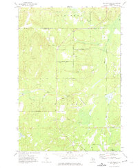
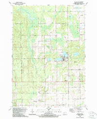
 1972 Goodar1975 Print · USGSThe northern Michigan woods of the early seventies are captured here during a period of steady forestry and recreation. Researchers can trace legacy timber routes like the Old RR Grade and locate features such as Goodar, Hughes Lake, and a Flowing Well.3 unique versions available
 - 1972 Map of Alcona Dam Pond, 1975 Print
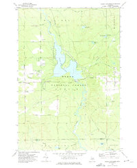 1972 Alcona Dam Pond1975 Print · USGSThe Au Sable River and the extensive Alcona Dam Pond define this Alcona County landscape in the early 1970s. Trace local family history at Curtisville and the Curtisville Cem, or locate the Alcona Dam and its associated powerplant.2 unique versions available
 - 1972 Map of McGinn Creek, 1975 Print
 1972 McGinn Creek1975 Print · USGSAlcona County's rural landscape is captured here in the early 1970s, featuring the dense woods of the Huron National Forest. Researchers can trace old family sites and transport routes through the Flynn Valley Cem, the Frutchey Ranch, and an Old Railroad Grade.
 - 1983 Map of Hubbard Lake, 1984 Print
 1983 Hubbard Lake1984 Print · USGSThe shorelines of Alcona and Alpena Counties come to life in this early 1980s overview of the Lake Huron coast and its deep timberlands. Researchers can trace historic rail routes like the Detroit and Mackinac or locate quiet inland hubs such as Barton City and Killmaster.
 - 1989 Map of Harrisville
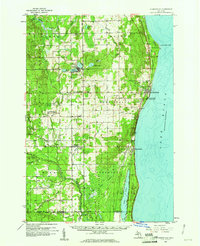
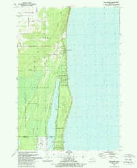
 1989 Harrisville1989 Print · USGSCoastal Alcona County comes into focus in the late 1980s, centered on the harbor at Harrisville and the historic lighthouse at Sturgeon Point. Genealogists and local historians can trace the Detroit and Mackinac rail line, Westtown Cem, and the Lighthouse guiding Lake Huron mariners.
 - 1989 Map of Barton City
 1989 Barton City1989 Print · USGSAlcona County's lake-and-forest landscape is captured here in the late eighties, showing the community at Barton City and the surrounding wilderness. Genealogists and local historians can trace landmarks like Maple Ridge Cemetery, Trinity Church, and the winding West Branch Pine River.
 - 1989 Map of Mikado
 1989 Mikado1989 Print · USGSAlcona County's forested interior is captured here in the late eighties, showing the rural communities and public lands west of Lake Huron. Genealogists and historians can locate the Oscoda Indian Mission, the County Line Sch, and the old Au Sable State Forest Railroad Grade.
 - 1989 Map of Lincoln
 1989 Lincoln1989 Print · USGSAlcona County in the late 1980s reveals a landscape defined by the Huron National Forest and the village of Lincoln. Researchers can trace the Old Railroad Grade or locate local landmarks like the Alcona High Sch, Killmaster, and Gustin.
 - 1989 Map of Glennie
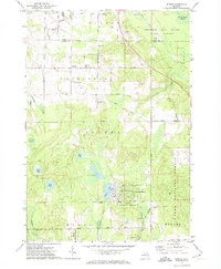
 1989 Glennie1989 Print · USGSAlcona County's forested interior is documented here during the late 1980s, centered on the community of Glennie and the surrounding national forest. Researchers can locate family landmarks like Glennie Cem or trace the old Detroit and Mackinac RR line near Vaughn Lake.
 - 1989 Map of Greenbush
 1989 Greenbush1989 Print · USGSCoastal Alcona County comes into focus in the late 1980s as it transitions from the shores of Lake Huron to the deep woods. Trace the family lands along Ridley Road or explore the waterfront developments near Greenbush and Cedar Lake.
 - 1989 Map of Sprinkler Lake
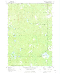
 1989 Sprinkler Lake1989 Print · USGSAlcona County's forested interior is documented here in the late eighties, showing a landscape defined by state and federal timberlands. You can trace early forest access routes like Rearing Pond Trail and locate landmarks such as Sprinkler Lake and the Flowing Well.
 - 1989 Map of Bucks Pond
 1989 Bucks Pond1989 Print · USGSThe Alcona County woodlands are shown here in the late eighties as the region balanced forestry with growing recreational use. Trace the path of the Old RR Grade, find family-named landmarks like Chin Whisker Hill, or locate remote wetlands such as Mossy Bog.
 - 2011 Map of Greenbush, 2011 Print
 2011 Greenbush2011 Print · USGSCovers Alcona County, including Greenbush, Greenbush Township, and other nearby areas
 - 2011 Map of Hubbard Lake, 2011 Print
 2011 Hubbard Lake2011 Print · USGSCovers Alcona County, including Ossineke Township, Hubbard Lake, and other nearby areas
Showing maps 1-25 of 113
Top cities of Alcona County
Frequently asked questions
- What are the different types of historical maps available for Alcona County?
- What is the oldest map of Alcona County?
- Where can I purchase historical maps of Alcona County for my home or office?
- Where can I download high-res historical maps of Alcona County?
- Are there historical topographic maps available for Alcona County?
- Is there historical aerial imagery available for Alcona County?
- Where are historical maps of Alcona County sourced from?