1980s Maps of Alcona County, Michigan
Explore 9 historic maps of Alcona County from the 1980s. These maps offer a rare glimpse into what life looked like during the 1980s — showing old roads, neighborhoods, homes, and landmarks that have changed or disappeared over time.
Whether you're researching your family's past, planning a metal detecting trip, or studying how Alcona County's landscape evolved across the 1980s, these high-resolution maps are a powerful tool for exploring the history of this region.
- Focus on a specific era: All maps on this page are from the 1980s, giving you a focused view of this time period.
- See what’s changed: Compare century-old streets, trails, and buildings to today's modern landscape using overlays and satellite layers.
- Research with precision: Use these maps for genealogy, historical research, land use analysis, or educational projects.
- View, download, or print: Maps are fully viewable online in high resolution, and can be downloaded or printed for your own records.
Start exploring Alcona County's history through authentic maps from the 1980s. This is your window into the past.
Alcona County, MI maps
(9)- 1983 Map of Hubbard Lake, 1984 Print
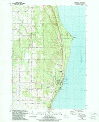
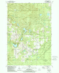
 1983 Hubbard Lake1984 Print · USGSThe shorelines of Alcona and Alpena Counties come to life in this early 1980s overview of the Lake Huron coast and its deep timberlands. Researchers can trace historic rail routes like the Detroit and Mackinac or locate quiet inland hubs such as Barton City and Killmaster.
 - 1989 Map of Harrisville
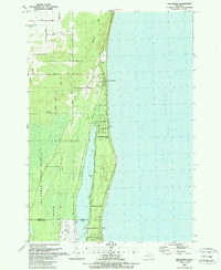
 1989 Harrisville1989 Print · USGSCoastal Alcona County comes into focus in the late 1980s, centered on the harbor at Harrisville and the historic lighthouse at Sturgeon Point. Genealogists and local historians can trace the Detroit and Mackinac rail line, Westtown Cem, and the Lighthouse guiding Lake Huron mariners.
 - 1989 Map of Barton City
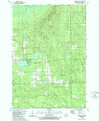 1989 Barton City1989 Print · USGSAlcona County's lake-and-forest landscape is captured here in the late eighties, showing the community at Barton City and the surrounding wilderness. Genealogists and local historians can trace landmarks like Maple Ridge Cemetery, Trinity Church, and the winding West Branch Pine River.
 - 1989 Map of Mikado
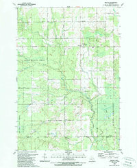 1989 Mikado1989 Print · USGSAlcona County's forested interior is captured here in the late eighties, showing the rural communities and public lands west of Lake Huron. Genealogists and historians can locate the Oscoda Indian Mission, the County Line Sch, and the old Au Sable State Forest Railroad Grade.
 - 1989 Map of Lincoln
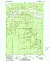
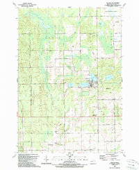 1989 Lincoln1989 Print · USGSAlcona County in the late 1980s reveals a landscape defined by the Huron National Forest and the village of Lincoln. Researchers can trace the Old Railroad Grade or locate local landmarks like the Alcona High Sch, Killmaster, and Gustin.
 - 1989 Map of Glennie
 1989 Glennie1989 Print · USGSAlcona County's forested interior is documented here during the late 1980s, centered on the community of Glennie and the surrounding national forest. Researchers can locate family landmarks like Glennie Cem or trace the old Detroit and Mackinac RR line near Vaughn Lake.
 - 1989 Map of Greenbush
 1989 Greenbush1989 Print · USGSCoastal Alcona County comes into focus in the late 1980s as it transitions from the shores of Lake Huron to the deep woods. Trace the family lands along Ridley Road or explore the waterfront developments near Greenbush and Cedar Lake.
 - 1989 Map of Sprinkler Lake
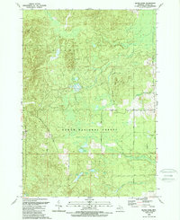
 1989 Sprinkler Lake1989 Print · USGSAlcona County's forested interior is documented here in the late eighties, showing a landscape defined by state and federal timberlands. You can trace early forest access routes like Rearing Pond Trail and locate landmarks such as Sprinkler Lake and the Flowing Well.
 - 1989 Map of Bucks Pond
 1989 Bucks Pond1989 Print · USGSThe Alcona County woodlands are shown here in the late eighties as the region balanced forestry with growing recreational use. Trace the path of the Old RR Grade, find family-named landmarks like Chin Whisker Hill, or locate remote wetlands such as Mossy Bog.
End of results
Showing maps 1-9 of 9
Top cities of Alcona County
Frequently asked questions
- What are the different types of historical maps available for Alcona County?
- What is the oldest map of Alcona County?
- Where can I purchase historical maps of Alcona County for my home or office?
- Where can I download high-res historical maps of Alcona County?
- Are there historical topographic maps available for Alcona County?
- Is there historical aerial imagery available for Alcona County?
- Where are historical maps of Alcona County sourced from?