1960s Maps of Chestonia Township, Michigan
Explore 2 historic maps of Chestonia Township from the 1960s. These maps offer a rare glimpse into what life looked like during the 1960s — showing old roads, neighborhoods, homes, and landmarks that have changed or disappeared over time.
Whether you're researching your family's past, planning a metal detecting trip, or studying how Chestonia Township's landscape evolved across the 1960s, these high-resolution maps are a powerful tool for exploring the history of this region.
- Focus on a specific era: All maps on this page are from the 1960s, giving you a focused view of this time period.
- See what’s changed: Compare century-old streets, trails, and buildings to today's modern landscape using overlays and satellite layers.
- Research with precision: Use these maps for genealogy, historical research, land use analysis, or educational projects.
- View, download, or print: Maps are fully viewable online in high resolution, and can be downloaded or printed for your own records.
Start exploring Chestonia Township's history through authentic maps from the 1960s. This is your window into the past.
Chestonia Township, MI maps
(2)- 1961 Map of Boyne Falls, 1963 Print
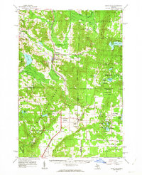 1961 Boyne Falls1963 Print · USGSNorthern Michigan’s timber and ski country is shown here in the early sixties as the recreational economy began to reshape the landscape. Researchers can trace family roots at St Augustine Cem, locate the old Schoolhouse, or follow the Pennsylvania rail line through Boyne Falls and Elmira.2 unique versions available
 - 1961 Map of Boyne City, 1963 Print
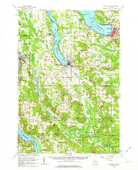 1961 Boyne City1963 Print · USGSCharlevoix and Antrim Counties are captured here in the early sixties, showing the transition between the glacial lake-country and the surrounding highland townships. Researchers can locate dozens of family-history landmarks like Vance Chapel, Calvary Cem, and the tracks of the Chesapeake and Ohio railroad.2 unique versions available
End of results
Showing maps 1-2 of 2
Top cities near Chestonia Township
- Boyne City historical maps
- East Jordan historical maps
- Elmira historical maps
- Mancelona historical maps
- Bellaire historical maps
- Central Lake historical maps
See more
Top neighborhoods of Chestonia Township
Frequently asked questions
- What are the different types of historical maps available for Chestonia Township?
- What is the oldest map of Chestonia Township?
- Where can I purchase historical maps of Chestonia Township for my home or office?
- Where can I download high-res historical maps of Chestonia Township?
- Are there historical topographic maps available for Chestonia Township?
- Is there historical aerial imagery available for Chestonia Township?
- Where are historical maps of Chestonia Township sourced from?