1980s Maps of Athens Township, Michigan
Explore 5 historic maps of Athens Township from the 1980s. These maps offer a rare glimpse into what life looked like during the 1980s — showing old roads, neighborhoods, homes, and landmarks that have changed or disappeared over time.
Whether you're researching your family's past, planning a metal detecting trip, or studying how Athens Township's landscape evolved across the 1980s, these high-resolution maps are a powerful tool for exploring the history of this region.
- Focus on a specific era: All maps on this page are from the 1980s, giving you a focused view of this time period.
- See what’s changed: Compare century-old streets, trails, and buildings to today's modern landscape using overlays and satellite layers.
- Research with precision: Use these maps for genealogy, historical research, land use analysis, or educational projects.
- View, download, or print: Maps are fully viewable online in high resolution, and can be downloaded or printed for your own records.
Start exploring Athens Township's history through authentic maps from the 1980s. This is your window into the past.
Athens Township, MI maps
(5)- 1982 Map of Leonidas
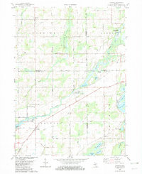 1982 Leonidas1982 Print · USGSSouthern Michigan farm country and river bottoms are captured here in the early eighties, centered on the village of Leonidas. Researchers can trace local lineages through Leonidas Cem or explore the site of Kings Mill and the Mission Ch.
 - 1982 Map of East Leroy
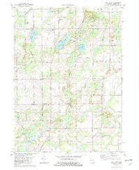 1982 East Leroy1982 Print · USGSThe rural landscape south of Battle Creek is detailed in the early eighties, showing a community defined by its township grids and natural drainage. Genealogists can locate family burial sites at Mather Cem and Walker Cem or trace the path of the Old RR Grade.
 - 1982 Map of Union City
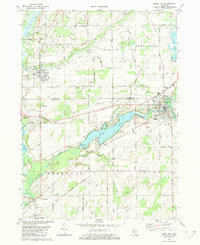 1982 Union City1982 Print · USGSThe confluence of the St Joseph and Coldwater Rivers defines this Branch County region in the early eighties. Genealogists and local historians can trace family plots at Old Burg Cem and Riverside Cem or locate the old CONRAIL tracks through Sherwood.
 - 1982 Map of Climax
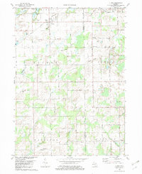 1982 Climax1982 Print · USGSThe borderlands of Kalamazoo and Calhoun Counties are captured here in the early 1980s, showcasing a landscape of established farmsteads and rural townships. Researchers can locate family heritage sites like West Leroy Cemetery, Northside Cemetery, and the Wakeshma Church.
 - 1982 Map of Kalamazoo, 1983 Print
 1982 Kalamazoo1983 Print · USGSThe Kalamazoo River valley in the early eighties shows a landscape of growing suburban centers and heavy rail infrastructure. Genealogists and researchers can trace the limits of Kalamazoo and Battle Creek or locate landmarks like Fort Custer National Cemetery and Gull Lake.
End of results
Showing maps 1-5 of 5
Top cities near Athens Township
- Battle Creek historical maps
- Coldwater historical maps
- Pavilion historical maps
- Springfield historical maps
- Nottawa historical maps
- Galesburg historical maps
See more
Top neighborhoods of Athens Township
Frequently asked questions
- What are the different types of historical maps available for Athens Township?
- What is the oldest map of Athens Township?
- Where can I purchase historical maps of Athens Township for my home or office?
- Where can I download high-res historical maps of Athens Township?
- Are there historical topographic maps available for Athens Township?
- Is there historical aerial imagery available for Athens Township?
- Where are historical maps of Athens Township sourced from?