2020s Maps of DeWitt Charter Township, Michigan
Explore 2 historic maps of DeWitt Charter Township from the 2020s. These maps offer a rare glimpse into what life looked like during the 2020s — showing old roads, neighborhoods, homes, and landmarks that have changed or disappeared over time.
Whether you're researching your family's past, planning a metal detecting trip, or studying how DeWitt Charter Township's landscape evolved across the 2020s, these high-resolution maps are a powerful tool for exploring the history of this region.
- Focus on a specific era: All maps on this page are from the 2020s, giving you a focused view of this time period.
- See what’s changed: Compare century-old streets, trails, and buildings to today's modern landscape using overlays and satellite layers.
- Research with precision: Use these maps for genealogy, historical research, land use analysis, or educational projects.
- View, download, or print: Maps are fully viewable online in high resolution, and can be downloaded or printed for your own records.
Start exploring DeWitt Charter Township's history through authentic maps from the 2020s. This is your window into the past.
DeWitt Charter Township, MI maps
(2)- 2023 Map of Bath, 2023 Print
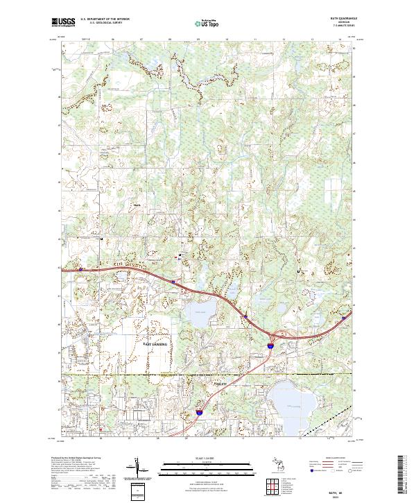 2023 Bath2023 Print · USGSThe transition from the Lansing suburbs to the Clinton County countryside is captured here in the early 2020s. Researchers can locate family heritage sites like Cushman Family Cem and Rose Cem alongside landmarks like Park Lake and Chandler Marsh.
 - 2023 Map of Lansing North, 2023 Print
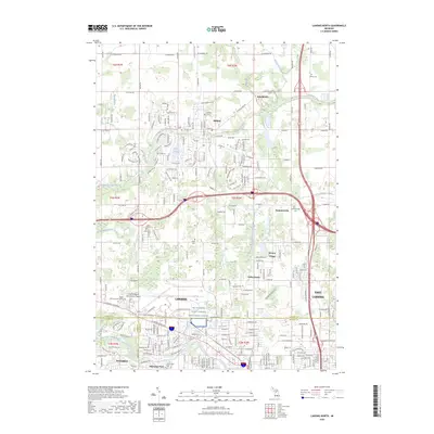 2023 Lansing North2023 Print · USGSThe northern reaches of the Lansing metropolitan area are documented here during a period of significant suburban and infrastructure growth. Researchers can locate established community landmarks like Gunnisonville Cem, trace the course of the Looking Glass River, and study the layout of the Capital Region International Airport.
End of results
Showing maps 1-2 of 2
Top cities near DeWitt Charter Township
- Lansing historical maps
- East Lansing historical maps
- Mason historical maps
- Grand Ledge historical maps
- St. Johns historical maps
- DeWitt historical maps
See more
Top neighborhoods of DeWitt Charter Township
- Clinton Village historical maps
- East DeWitt historical maps
- Gunnisonville historical maps
- Valley Farms historical maps
- Alana Woods historical maps
- Ridge Rock historical maps
Frequently asked questions
- What are the different types of historical maps available for DeWitt Charter Township?
- What is the oldest map of DeWitt Charter Township?
- Where can I purchase historical maps of DeWitt Charter Township for my home or office?
- Where can I download high-res historical maps of DeWitt Charter Township?
- Are there historical topographic maps available for DeWitt Charter Township?
- Is there historical aerial imagery available for DeWitt Charter Township?
- Where are historical maps of DeWitt Charter Township sourced from?