1970s Maps of Pinecrest, East Lansing
Explore 2 historic maps of Pinecrest from the 1970s. These maps offer a rare glimpse into what life looked like during the 1970s — showing old roads, neighborhoods, homes, and landmarks that have changed or disappeared over time.
Whether you're researching your family's past, planning a metal detecting trip, or studying how Pinecrest's landscape evolved across the 1970s, these high-resolution maps are a powerful tool for exploring the history of this region.
- Focus on a specific era: All maps on this page are from the 1970s, giving you a focused view of this time period.
- See what’s changed: Compare century-old streets, trails, and buildings to today's modern landscape using overlays and satellite layers.
- Research with precision: Use these maps for genealogy, historical research, land use analysis, or educational projects.
- View, download, or print: Maps are fully viewable online in high resolution, and can be downloaded or printed for your own records.
Start exploring Pinecrest's history through authentic maps from the 1970s. This is your window into the past.
Pinecrest, East Lansing maps
(2)- 1970 Map of East Lansing, 1973 Print
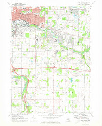 1970 East Lansing1973 Print · USGSThe East Lansing area and surrounding townships are captured here in the early 1970s as suburban growth expanded eastward. Researchers can trace local landmarks like Michigan State University, Okemos Station, and the Leek Cems.3 unique versions available
 - 1972 Map of Bath, 1974 Print
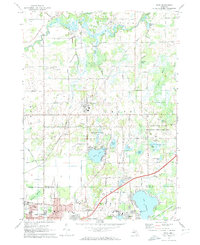 1972 Bath1974 Print · USGSClinton and Ingham counties are shown in the early seventies as residential growth began to meet the traditional marshlands and river valleys. Researchers can trace family sites at Pleasant Hill Cemetery or explore local landmarks like Davis Airport and the Amusement Park at Lake Lansing.2 unique versions available
End of results
Showing maps 1-2 of 2
Frequently asked questions
- What are the different types of historical maps available for Pinecrest?
- What is the oldest map of Pinecrest?
- Where can I purchase historical maps of Pinecrest for my home or office?
- Where can I download high-res historical maps of Pinecrest?
- Are there historical topographic maps available for Pinecrest?
- Is there historical aerial imagery available for Pinecrest?
- Where are historical maps of Pinecrest sourced from?