1970s Maps of Leslie Township, Michigan
Explore 4 historic maps of Leslie Township from the 1970s. These maps offer a rare glimpse into what life looked like during the 1970s — showing old roads, neighborhoods, homes, and landmarks that have changed or disappeared over time.
Whether you're researching your family's past, planning a metal detecting trip, or studying how Leslie Township's landscape evolved across the 1970s, these high-resolution maps are a powerful tool for exploring the history of this region.
- Focus on a specific era: All maps on this page are from the 1970s, giving you a focused view of this time period.
- See what’s changed: Compare century-old streets, trails, and buildings to today's modern landscape using overlays and satellite layers.
- Research with precision: Use these maps for genealogy, historical research, land use analysis, or educational projects.
- View, download, or print: Maps are fully viewable online in high resolution, and can be downloaded or printed for your own records.
Start exploring Leslie Township's history through authentic maps from the 1970s. This is your window into the past.
Leslie Township, MI maps
(4)- 1970 Map of Munith, 1972 Print
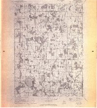 1970 Munith1972 Print · USGSIngham and Jackson counties meet in this 1970s record of rural Michigan, showing the agricultural and lakeside communities before significant modern expansion. Genealogists can trace family footprints through historic burial grounds like Bunker Hill Cemetery and the rail-side settlement of Munith along the Grand Trunk Western line.3 unique versions available
 - 1970 Map of Leslie, 1973 Print
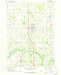 1970 Leslie1973 Print · USGSMid-Michigan's river-fed farm country is captured here during the early seventies, spanning the border of Ingham and Jackson Counties. Researchers can trace the Grand River through Berryville, locate family plots at Walker Cem, or follow the Old Penn Central Railroad north through Leslie.
 - 1970 Map of Mason, 1973 Print
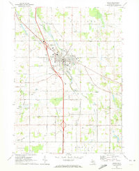 1970 Mason1973 Print · USGSMason and its surrounding townships are captured in the early seventies, showing a balanced landscape of county government, aviation, and agriculture. Researchers can trace the Penn Central Railroad and locate ancestral sites like Maple Grove Cem and Eden Cem.
 - 1970 Map of Dansville, 1989 Print
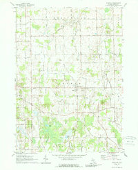 1970 Dansville1989 Print · USGSDansville and the surrounding Ingham County townships are captured here in the late sixties, showing a landscape of small-scale farms and creek-fed wetlands. Genealogists and historians can trace family locations near Fairview Cem, the old settlement at Pollok, or along the historic Dexter Trail.3 unique versions available
End of results
Showing maps 1-4 of 4
Top cities near Leslie Township
- Lansing historical maps
- Jackson historical maps
- Leoni historical maps
- Spring Arbor Township historical maps
- Mason historical maps
- Eaton Rapids historical maps
See more
Top neighborhoods of Leslie Township
Frequently asked questions
- What are the different types of historical maps available for Leslie Township?
- What is the oldest map of Leslie Township?
- Where can I purchase historical maps of Leslie Township for my home or office?
- Where can I download high-res historical maps of Leslie Township?
- Are there historical topographic maps available for Leslie Township?
- Is there historical aerial imagery available for Leslie Township?
- Where are historical maps of Leslie Township sourced from?