Old Maps of Iosco County, Michigan for Genealogy
Trace your family roots with 145 historic maps of Iosco County. These high-res maps reveal old neighborhoods, homesites, landmarks, and streets — helping you uncover where your ancestors lived and how the area evolved over time.
- Explore historic neighborhoods: Identify where your relatives may have lived in the 1800s or 1900s.
- Compare maps over time: Trace the changes in streets, buildings, and landmarks for multi-generational research.
- Perfect for genealogy & ancestry research: Used by family historians and researchers to map out lineage and migration.
These maps are an incredible resource for exploring your personal connection to Iosco County's past.
Iosco County, MI maps
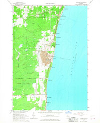
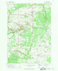
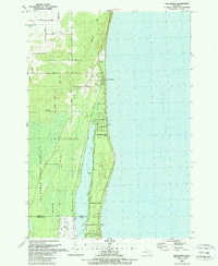
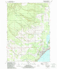
(145)- 1954 Map of Tawas City, 1968 Print
 1954 Tawas City1968 Print · USGSCoastal life along Lake Huron was defined by a mix of military aviation and hydroelectric power in the mid-fifties. Researchers can trace the river dams like Cooke Dam, the layout of Wurtsmith AFB, and the coastal mining operations at Alabaster.4 unique versions available
 - 1958 Map of Tawas City
 1958 Tawas City1958 Print · USGSThe Lake Huron shoreline and northern Michigan timberlands come into focus in the late fifties, during the expansion of the Cold War. Genealogists and historians can trace rail lines like the Detroit and Mackinac, find regional landmarks like the Lumbermans Memorial Monument, and locate coastal facilities including Wurtsmith AFB.2 unique versions available
 - 1959 Map of Tawas City, 1960 Print
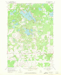
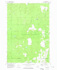
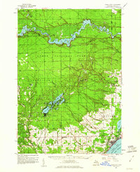 1959 Tawas City1960 Print · USGSIosco County at the end of the 1950s shows a landscape defined by the Au Sable River’s hydroelectric basins and the growing lakeshore communities of Tawas Bay. Researchers can trace genealogical roots at Wilber Ch and Zion Cem or locate vanished sites like Sid Town and the Wurtsmith Air Force Range.4 unique versions available
 - 1959 Map of East Tawas, 1960 Print
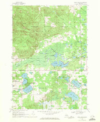
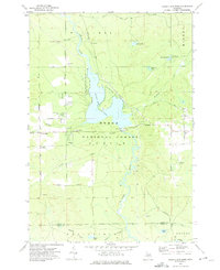
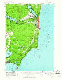 1959 East Tawas1960 Print · USGSCoastal Iosco County comes to life in the late fifties, where military aviation and shoreline industry meet the Huron National Forest. Researchers can trace the layout of Wurtsmith Air Force Base or locate local landmarks like Chippewa Cem and the Foote Dam.3 unique versions available
 - 1959 Map of Glennie, 1961 Print
 1959 Glennie1961 Print · USGSAlcona County's lake country and timberlands are captured here in the late fifties as military activity and forest management shaped the region. Genealogists and historians can trace the exact locations of Lott Ch, Glennie Cem, and the sprawling Wurtsmith Air Force Range.3 unique versions available
 - 1959 Map of Harrisville, 1961 Print
 1959 Harrisville1961 Print · USGSThe Alcona County coast and its timbered interior are captured here at the end of the 1950s as the regional economy balanced forestry and lakefront tourism. Genealogists can trace family names through rural sites like St Annes Cem, Calvary Ch, and the Indian Mission near the Iosco County line.3 unique versions available
 - 1966 Map of Alabaster, 1968 Print
 1966 Alabaster1968 Print · USGSCoastal Michigan in the late sixties reveals a landscape of industrial quarries and growing bayside communities along Saginaw Bay. Genealogists and historians can trace the lakeside residential rows from Huron Oaks to Harmon City Heights and locate local landmarks like Township Cem and the railroad at Alabaster Junction.2 unique versions available
 - 1966 Map of National City, 1968 Print
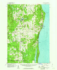
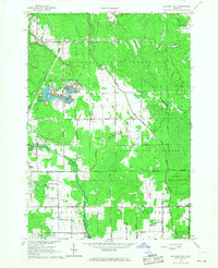 1966 National City1968 Print · USGSIosco County in the mid-1960s reveals a landscape shaped by timber, rail, and an intricate drainage network. Trace the Detroit and Mackinac RR through McIvor, locate Quarries near the county line, and find the Sherman Sch.2 unique versions available
 - 1968 Map of Hale, 1971 Print
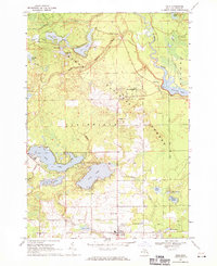 1968 Hale1971 Print · USGSIosco County’s lake country and the Au Sable River valley are captured here in the late sixties as a thriving center for recreation and forestry. Genealogists and researchers can locate Hale, Plainfield Park, and historic burial sites at Thompson Cem or Hale Cem.3 unique versions available
 - 1968 Map of Prescott, 1971 Print
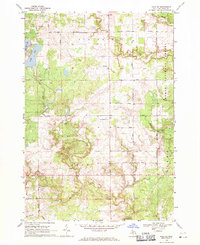
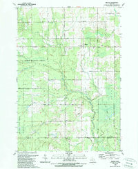
 1968 Prescott1971 Print · USGSNorthern Michigan in the late sixties reveals a landscape of rural villages and energy extraction. Trace local family history at Richland Cem or follow the Old Railroad Grade past Prescott and the Oil Wells near Maple Ridge.
 - 1968 Map of Whittemore, 1971 Print
 1968 Whittemore1971 Print · USGSWhittemore and Turner are captured in the late sixties as the surrounding landscapes were still heavily defined by state forestry and old rail corridors. Researchers can find historical burial sites like Cedar Valley Cemetery and follow the paths of the Au Gres River and the Old Railroad Grade.
 - 1968 Map of Sage Lake, 1971 Print
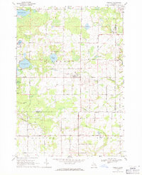
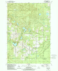
 1968 Sage Lake1971 Print · USGSThe Ogemaw and Iosco county line area comes to life in the late 1960s, showing a landscape defined by the expansive Sage Lake and the Ogemaw State Forest. Genealogists and local historians can trace family locations near Logan Corners, Logan Cemetery, and the Church of the Nazarene.
 - 1968 Map of South Branch, 1971 Print
 1968 South Branch1971 Print · USGSOgemaw County in the late sixties reveals a landscape of dense state and national forests and numerous glacial lakes. Genealogists and historians can locate South Branch and Goodar, trace the South Branch Au Sable River, and find the Oak Grove Cem.2 unique versions available
 - 1968 Map of Hale SE, 1971 Print
 1968 Hale SE1971 Print · USGSIosco County in the late sixties reveals a landscape of river-fed marshes and established township grids. Genealogists and local historians can trace the rural community through landmarks like Reno Cem, the Hale Lookout Tower, and the waters of Londo Lake.
 - 1972 Map of Goodar, 1975 Print
 1972 Goodar1975 Print · USGSThe northern Michigan woods of the early seventies are captured here during a period of steady forestry and recreation. Researchers can trace legacy timber routes like the Old RR Grade and locate features such as Goodar, Hughes Lake, and a Flowing Well.3 unique versions available
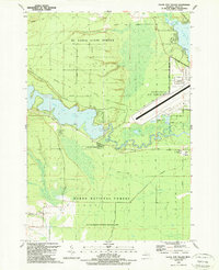
 - 1972 Map of Alcona Dam Pond, 1975 Print
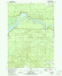
 1972 Alcona Dam Pond1975 Print · USGSThe Au Sable River and the extensive Alcona Dam Pond define this Alcona County landscape in the early 1970s. Trace local family history at Curtisville and the Curtisville Cem, or locate the Alcona Dam and its associated powerplant.2 unique versions available
 - 1983 Map of Hubbard Lake, 1984 Print
 1983 Hubbard Lake1984 Print · USGSThe shorelines of Alcona and Alpena Counties come to life in this early 1980s overview of the Lake Huron coast and its deep timberlands. Researchers can trace historic rail routes like the Detroit and Mackinac or locate quiet inland hubs such as Barton City and Killmaster.
 - 1984 Map of Tawas City, 1985 Print
 1984 Tawas City1985 Print · USGSNortheast Michigan's shoreline and forest interior are captured here in the mid-eighties, from the active runways of Wurtsmith Air Force Base to the quiet waters of Tawas Bay. Genealogists and local historians can locate rural landmarks like Skunk Sch, the Welcome Church, and the route of the Detroit and Mackinac railroad.3 unique versions available
 - 1989 Map of Mikado
 1989 Mikado1989 Print · USGSAlcona County's forested interior is captured here in the late eighties, showing the rural communities and public lands west of Lake Huron. Genealogists and historians can locate the Oscoda Indian Mission, the County Line Sch, and the old Au Sable State Forest Railroad Grade.
 - 1989 Map of Glennie
 1989 Glennie1989 Print · USGSAlcona County's forested interior is documented here during the late 1980s, centered on the community of Glennie and the surrounding national forest. Researchers can locate family landmarks like Glennie Cem or trace the old Detroit and Mackinac RR line near Vaughn Lake.
 - 1989 Map of Greenbush
 1989 Greenbush1989 Print · USGSCoastal Alcona County comes into focus in the late 1980s as it transitions from the shores of Lake Huron to the deep woods. Trace the family lands along Ridley Road or explore the waterfront developments near Greenbush and Cedar Lake.
 - 1989 Map of Foote Site Village
 1989 Foote Site Village1989 Print · USGSIosco County’s Au Sable River valley is captured here in the late eighties, showing a landscape defined by the strategic Cold War presence of Wurtsmith Air Force Base. Researchers can locate local landmarks like the Chippewa Cem, the Foote Dam Powerplant, and rural schoolhouses including River Road Sch.
 - 1989 Map of East Tawas
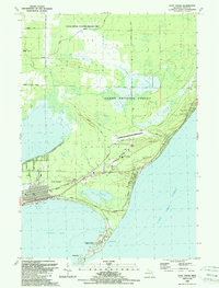 1989 East Tawas1989 Print · USGSEast Tawas and the shoreline of Lake Huron are captured in the late eighties as the region balanced conservation and coastal growth. Researchers can locate the Lighthouse and U. S. Coast Guard Sta at Tawas Point, or trace local landmarks like Greenwood Cem and the Drive-in Theater.
 - 1989 Map of Sid Town
 1989 Sid Town1989 Print · USGSIosco County in the late eighties is defined by the hydroelectric developments on the river and the deep timberlands of the national forest. Researchers can trace the layout of Sid Town and locate landmarks like the Cooke Powerplant and Wilber Ch.
 - 1989 Map of Tawas City
 1989 Tawas City1989 Print · USGSThe Lake Huron shoreline and Tawas Bay come alive in the late eighties as the twin cities expand against the Huron National Forest. Researchers can trace family-named sites and rural landmarks like Laidlaw Cem, Wilber Cem, and the Tawas Golf Course.
Showing maps 1-25 of 145
Top cities of Iosco County
Frequently asked questions
- What are the different types of historical maps available for Iosco County?
- What is the oldest map of Iosco County?
- Where can I purchase historical maps of Iosco County for my home or office?
- Where can I download high-res historical maps of Iosco County?
- Are there historical topographic maps available for Iosco County?
- Is there historical aerial imagery available for Iosco County?
- Where are historical maps of Iosco County sourced from?