1900s (20th Century) Maps of Grant Township, Michigan
Explore 8 historic maps of Grant Township from the 1900s (20th Century). These maps offer a rare glimpse into what life looked like during the 1900s — showing old roads, neighborhoods, homes, and landmarks that have changed or disappeared over time.
Whether you're researching your family's past, planning a metal detecting trip, or studying how Grant Township's landscape evolved across the 1900s, these high-resolution maps are a powerful tool for exploring the history of this region.
- Focus on a specific era: All maps on this page are from the 1900s, giving you a focused view of this time period.
- See what’s changed: Compare century-old streets, trails, and buildings to today's modern landscape using overlays and satellite layers.
- Research with precision: Use these maps for genealogy, historical research, land use analysis, or educational projects.
- View, download, or print: Maps are fully viewable online in high resolution, and can be downloaded or printed for your own records.
Start exploring Grant Township's history through authentic maps from the 1900s. This is your window into the past.
Grant Township, MI maps
(8)- 1954 Map of Tawas City, 1968 Print
 1954 Tawas City1968 Print · USGSCoastal life along Lake Huron was defined by a mix of military aviation and hydroelectric power in the mid-fifties. Researchers can trace the river dams like Cooke Dam, the layout of Wurtsmith AFB, and the coastal mining operations at Alabaster.4 unique versions available
 - 1958 Map of Tawas City
 1958 Tawas City1958 Print · USGSThe Lake Huron shoreline and northern Michigan timberlands come into focus in the late fifties, during the expansion of the Cold War. Genealogists and historians can trace rail lines like the Detroit and Mackinac, find regional landmarks like the Lumbermans Memorial Monument, and locate coastal facilities including Wurtsmith AFB.2 unique versions available
 - 1959 Map of Tawas City, 1960 Print
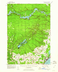 1959 Tawas City1960 Print · USGSIosco County at the end of the 1950s shows a landscape defined by the Au Sable River’s hydroelectric basins and the growing lakeshore communities of Tawas Bay. Researchers can trace genealogical roots at Wilber Ch and Zion Cem or locate vanished sites like Sid Town and the Wurtsmith Air Force Range.4 unique versions available
 - 1966 Map of National City, 1968 Print
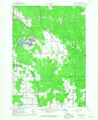 1966 National City1968 Print · USGSIosco County in the mid-1960s reveals a landscape shaped by timber, rail, and an intricate drainage network. Trace the Detroit and Mackinac RR through McIvor, locate Quarries near the county line, and find the Sherman Sch.2 unique versions available
 - 1968 Map of Whittemore, 1971 Print
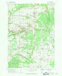 1968 Whittemore1971 Print · USGSWhittemore and Turner are captured in the late sixties as the surrounding landscapes were still heavily defined by state forestry and old rail corridors. Researchers can find historical burial sites like Cedar Valley Cemetery and follow the paths of the Au Gres River and the Old Railroad Grade.
 - 1968 Map of Hale SE, 1971 Print
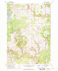 1968 Hale SE1971 Print · USGSIosco County in the late sixties reveals a landscape of river-fed marshes and established township grids. Genealogists and local historians can trace the rural community through landmarks like Reno Cem, the Hale Lookout Tower, and the waters of Londo Lake.
 - 1984 Map of Tawas City, 1985 Print
 1984 Tawas City1985 Print · USGSNortheast Michigan's shoreline and forest interior are captured here in the mid-eighties, from the active runways of Wurtsmith Air Force Base to the quiet waters of Tawas Bay. Genealogists and local historians can locate rural landmarks like Skunk Sch, the Welcome Church, and the route of the Detroit and Mackinac railroad.3 unique versions available
 - 1989 Map of Floyd Lake
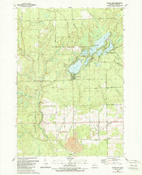 1989 Floyd Lake1989 Print · USGSIosco County in the late 1980s reveals a lakeside landscape managed for recreation and industry. Researchers can trace family sites at Pioneer Cem, locate the old Strip Mine near White Rock, and explore the shoreline of Sand Lake and Indian Lake.
End of results
Showing maps 1-8 of 8
Top cities near Grant Township
- East Tawas historical maps
- Tawas City historical maps
- Wilber historical maps
- Goodar historical maps
- Alabaster historical maps
- Whittemore historical maps
See more
Top neighborhoods of Grant Township
Frequently asked questions
- What are the different types of historical maps available for Grant Township?
- What is the oldest map of Grant Township?
- Where can I purchase historical maps of Grant Township for my home or office?
- Where can I download high-res historical maps of Grant Township?
- Are there historical topographic maps available for Grant Township?
- Is there historical aerial imagery available for Grant Township?
- Where are historical maps of Grant Township sourced from?