1940s Maps of Mansfield Township, Michigan
Explore 2 historic maps of Mansfield Township from the 1940s. These maps offer a rare glimpse into what life looked like during the 1940s — showing old roads, neighborhoods, homes, and landmarks that have changed or disappeared over time.
Whether you're researching your family's past, planning a metal detecting trip, or studying how Mansfield Township's landscape evolved across the 1940s, these high-resolution maps are a powerful tool for exploring the history of this region.
- Focus on a specific era: All maps on this page are from the 1940s, giving you a focused view of this time period.
- See what’s changed: Compare century-old streets, trails, and buildings to today's modern landscape using overlays and satellite layers.
- Research with precision: Use these maps for genealogy, historical research, land use analysis, or educational projects.
- View, download, or print: Maps are fully viewable online in high resolution, and can be downloaded or printed for your own records.
Start exploring Mansfield Township's history through authentic maps from the 1940s. This is your window into the past.
Mansfield Township, MI maps
(2)- 1947 Map of Kiernan
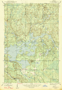 1947 Kiernan1947 Print · USGSIron County’s timber and water landscapes are captured here shortly after the war, showing the newly formed Michigamme Reservoir. Genealogists and historians can trace the rail corridor of the Chicago Milwaukee St Paul and Pacific and the small settlement at Kiernan.2 unique versions available
 - 1947 Map of Lake Mary
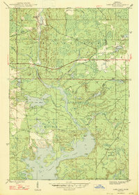 1947 Lake Mary1947 Print · USGSIron County, Michigan, is shown here shortly after the war, where the industrial legacy of the Northwoods meets its sprawling river system. Researchers can trace the Old Railroad Grade past Mansfield or locate School No 2 near the banks of the Michigan River.2 unique versions available
End of results
Showing maps 1-2 of 2
Top cities near Mansfield Township
- Crystal Falls historical maps
- Republic historical maps
- Sagola historical maps
- Mastodon historical maps
- Florence historical maps
- Mansfield historical maps
See more
Top neighborhoods of Mansfield Township
Frequently asked questions
- What are the different types of historical maps available for Mansfield Township?
- What is the oldest map of Mansfield Township?
- Where can I purchase historical maps of Mansfield Township for my home or office?
- Where can I download high-res historical maps of Mansfield Township?
- Are there historical topographic maps available for Mansfield Township?
- Is there historical aerial imagery available for Mansfield Township?
- Where are historical maps of Mansfield Township sourced from?