1900s (20th Century) Maps of Little Betsy, Grant Township
Explore 9 historic maps of Little Betsy from the 1900s (20th Century). These maps offer a rare glimpse into what life looked like during the 1900s — showing old roads, neighborhoods, homes, and landmarks that have changed or disappeared over time.
Whether you're researching your family's past, planning a metal detecting trip, or studying how Little Betsy's landscape evolved across the 1900s, these high-resolution maps are a powerful tool for exploring the history of this region.
- Focus on a specific era: All maps on this page are from the 1900s, giving you a focused view of this time period.
- See what’s changed: Compare century-old streets, trails, and buildings to today's modern landscape using overlays and satellite layers.
- Research with precision: Use these maps for genealogy, historical research, land use analysis, or educational projects.
- View, download, or print: Maps are fully viewable online in high resolution, and can be downloaded or printed for your own records.
Start exploring Little Betsy's history through authentic maps from the 1900s. This is your window into the past.
Little Betsy, Grant Township maps
(9)- 1939 Map of Deer Lake
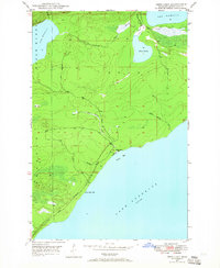
 1939 Deer Lake1939 Print · USGSThe Keweenaw Peninsula shore in the late thirties shows a landscape of remote schools and winding river systems. Trace early landmarks like the Betsy River Sch, the waters of Lac La Belle, and the rocky shoreline at Black Rock Pt.
 - 1940 Map of Deer Lake
 1940 Deer Lake1940 Print · USGSThe Keweenaw Peninsula shoreline comes alive in the late 1930s as aerial photography reveals the remote coastal reaches of Lake Superior. Researchers can trace the drainage of the Big Betsy River or locate the site of the Betsy River Sch and Black Rock Pt.
 - 1948 Map of Deer Lake, 1965 Print
 1948 Deer Lake1965 Print · USGSKeweenaw's rugged shoreline and interior waterways are captured here in the late 1940s as a new coastal road was first being carved. Researchers can trace the early path of the road UNDER CONSTRUCTION near Black Rock Point or locate the site of the Betsy River School.3 unique versions available
 - 1949 Map of Deer Lake
 1949 Deer Lake1949 Print · USGSKeweenaw Peninsula wilderness meets the coast of Lake Superior in the late 1940s. Genealogists and researchers can locate the Betsy River Sch and trace the early development of roads under construction near Black Rock Point.
 - 1958 Map of Hancock, 1967 Print
 1958 Hancock1967 Print · USGSThe Keweenaw Peninsula and Isle Royale are seen here during the mid-twentieth century as mining and maritime hubs. Trace the dense town layouts of Hancock and Calumet, or locate remote coastal markers like the Eagle Harbor Lighthouse and Rock of Ages Light.2 unique versions available
 - 1960 Map of Hancock
 1960 Hancock1960 Print · USGSThe Keweenaw Peninsula and Isle Royale are captured in detail during the late 1950s. Researchers can trace copper-mining era settlements like Calumet and Laurium, or locate remote maritime landmarks such as the Isle Royale Lighthouse.
 - 1961 Map of Hancock
 1961 Hancock1961 Print · USGSThe Keweenaw Peninsula and Isle Royale are shown here at the start of the 1960s, featuring the region's historic copper mining and maritime infrastructure. Genealogists and researchers can trace local families through settlements like Atlantic Mine and Painesdale, or locate remote landmarks including Rock of Ages Light and Eagle Harbor.
 - 1966 Map of Hancock, 1987 Print
 1966 Hancock1987 Print · USGSThe Keweenaw Peninsula and Isle Royale are captured in the mid-1960s during a pivotal era for Michigan’s Copper Country. Trace the industrial footprint of the SOO LINE through Calumet or locate historic maritime landmarks like Fort Wilkins and Rock of Ages Light.
 - 1985 Map of Hancock
 1985 Hancock1985 Print · USGSThe Keweenaw Peninsula in the mid-1980s reveals a landscape shaped by copper and the Great Lakes. You can trace the industrial legacy of the region through the Quincy Mine, the Old RR Grade, and old cemeteries like Forest Hill Cem.3 unique versions available
End of results
Showing maps 1-9 of 9
Top cities near Little Betsy
Frequently asked questions
- What are the different types of historical maps available for Little Betsy?
- What is the oldest map of Little Betsy?
- Where can I purchase historical maps of Little Betsy for my home or office?
- Where can I download high-res historical maps of Little Betsy?
- Are there historical topographic maps available for Little Betsy?
- Is there historical aerial imagery available for Little Betsy?
- Where are historical maps of Little Betsy sourced from?