1940s Maps of Mandan, Grant Township
Explore 2 historic maps of Mandan from the 1940s. These maps offer a rare glimpse into what life looked like during the 1940s — showing old roads, neighborhoods, homes, and landmarks that have changed or disappeared over time.
Whether you're researching your family's past, planning a metal detecting trip, or studying how Mandan's landscape evolved across the 1940s, these high-resolution maps are a powerful tool for exploring the history of this region.
- Focus on a specific era: All maps on this page are from the 1940s, giving you a focused view of this time period.
- See what’s changed: Compare century-old streets, trails, and buildings to today's modern landscape using overlays and satellite layers.
- Research with precision: Use these maps for genealogy, historical research, land use analysis, or educational projects.
- View, download, or print: Maps are fully viewable online in high resolution, and can be downloaded or printed for your own records.
Start exploring Mandan's history through authentic maps from the 1940s. This is your window into the past.
Mandan, Grant Township maps
(2)- 1948 Map of Delaware, 1955 Print
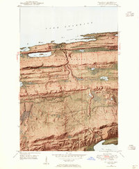 1948 Delaware1955 Print · USGSKeweenaw County’s rugged northern tip appears in the late 1940s, from the rocky harbor at Agate Point down to the settlement at Delaware. You can trace the complex geography of the Montreal River valley and find early mining-era sites like Mandan and Lac La Belle.8 unique versions available
 - 1949 Map of Delaware
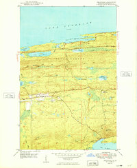 1949 Delaware1949 Print · USGSThe Keweenaw Peninsula’s rugged northern coast and interior ridges are captured here just after the war. Genealogists and local historians can locate the early settlements of Delaware and Mandan or trace the winding Montreal River toward Lac La Belle.4 unique versions available
End of results
Showing maps 1-2 of 2
Top cities near Mandan
Frequently asked questions
- What are the different types of historical maps available for Mandan?
- What is the oldest map of Mandan?
- Where can I purchase historical maps of Mandan for my home or office?
- Where can I download high-res historical maps of Mandan?
- Are there historical topographic maps available for Mandan?
- Is there historical aerial imagery available for Mandan?
- Where are historical maps of Mandan sourced from?