1950s Maps of Leelanau County, Michigan
Explore 15 historic maps of Leelanau County from the 1950s. These maps offer a rare glimpse into what life looked like during the 1950s — showing old roads, neighborhoods, homes, and landmarks that have changed or disappeared over time.
Whether you're researching your family's past, planning a metal detecting trip, or studying how Leelanau County's landscape evolved across the 1950s, these high-resolution maps are a powerful tool for exploring the history of this region.
- Focus on a specific era: All maps on this page are from the 1950s, giving you a focused view of this time period.
- See what’s changed: Compare century-old streets, trails, and buildings to today's modern landscape using overlays and satellite layers.
- Research with precision: Use these maps for genealogy, historical research, land use analysis, or educational projects.
- View, download, or print: Maps are fully viewable online in high resolution, and can be downloaded or printed for your own records.
Start exploring Leelanau County's history through authentic maps from the 1950s. This is your window into the past.
Leelanau County, MI maps
(15)- 1954 Map of Traverse City, 1965 Print
 1954 Traverse City1965 Print · USGSNorthern Michigan’s vast lakeshores and timberlands are captured here in the mid-fifties, showing the region before the modern interstate era. Genealogists and researchers can trace rail connections like the Detroit and Mackinac RR or find old communities such as Suttons Bay, Elk Rapids, and Prudenville.4 unique versions available
 - 1954 Map of Escanaba, 1967 Print
 1954 Escanaba1967 Print · USGSThe Upper Peninsula and Door County shorelines meet here in the mid-fifties, showing the vital maritime and timber networks of the Great Lakes. Researchers can trace historic rail lines, old fire lookouts like the Stonington Fire Tower, and island settlements such as Washington Island.2 unique versions available
 - 1954 Map of Manitowoc, 1968 Print
 1954 Manitowoc1968 Print · USGSLake Michigan served as a vital transit corridor in the mid-fifties, with car and auto ferries linking the industrial ports of Wisconsin to the Michigan timberlands. Genealogists and maritime historians can trace active ferry routes like the Ann Arbor Railway Car and Auto Ferry and locate early settlements from Brussels to Algoma.2 unique versions available
 - 1955 Map of Cheboygan, 1964 Print
 1955 Cheboygan1964 Print · USGSNorthern Michigan in the mid-fifties is a landscape of dense timber and deep water, showing the region just as the road network began to modernize. Trace family roots in lakeside towns like St Ignace and Petoskey, or follow the historic tracks of the Pennsylvania RR and New York Central RR.5 unique versions available
 - 1956 Map of North Manitou, 1958 Print
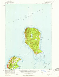 1956 North Manitou1958 Print · USGSNorth Manitou and South Manitou islands are captured here in the mid-fifties, showing a landscape of maritime navigation and quiet interior lakes. Researchers can locate the N Manitou I Sch (Abandoned), the S Manitou I Cem, and the vital Lifeboat Station.2 unique versions available
 - 1956 Map of South Fox Island, 1959 Print
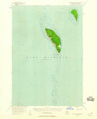 1956 South Fox Island1959 Print · USGSIsolated in the waters of Lake Michigan during the mid-fifties, these islands represent a unique maritime outpost within Leelanau Twp. Researchers can trace the layout of the South Fox Island Lighthouse and the early Landing Field on the southern island.2 unique versions available
 - 1957 Map of Escanaba
 1957 Escanaba1957 Print · USGSThe Upper Peninsula and Door County shorelines meet in the mid-fifties, capturing a landscape of timber, iron, and maritime trade. Genealogists and local historians can trace the Chicago & North Western RR through settlements like Hermansville or locate St Vitals Church and the Potawatome Indian Reservation.
 - 1957 Map of Traverse City, 1958 Print
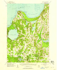
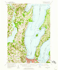 1957 Traverse City1958 Print · USGSThe Grand Traverse region flourished in the mid-fifties as a center for cherry orchards and lakeside commerce. Trace ancestral roots at the Maple Grove Cem or locate historic landmarks like Fountain Point and the Clinck Park Zoo.2 unique versions available
 - 1957 Map of Empire, 1958 Print
 1957 Empire1958 Print · USGSThe Leelanau Peninsula coast in the mid-fifties shows a rugged landscape of shifting sands and Cold War defense. Genealogists and historians can locate Maple Grove Cem, the sprawling Sleeping Bear Dunes, and the Empire Air Force Station.2 unique versions available
 - 1957 Map of Northport, 1958 Print
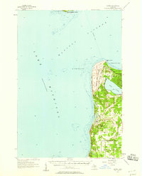
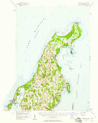 1957 Northport1958 Print · USGSThe tip of Michigan's Leelanau Peninsula is captured here in the late fifties, showcasing its unique bayside settlements and maritime history. Genealogists and local historians can locate St Wenceslaus Ch, the village of Peshawbestown, and the Grand Traverse Light.2 unique versions available
 - 1957 Map of Maple City, 1958 Print
 1957 Maple City1958 Print · USGSLeelanau County's lake-studded landscape is captured here in the late fifties, showing the interplay between forest and settlement. Researchers can trace family sites at St Joseph Cem & Ch, the North Unity Sch, and Port Oneida.3 unique versions available
 - 1958 Map of Escanaba
 1958 Escanaba1958 Print · USGSNorthern Lake Michigan maritime commerce and timberlands are captured here in the mid-fifties. Genealogists and historians can trace rail networks like the Escanaba and Lake Superior or locate island settlements such as Detroit Harbor and Fish Creek.
 - 1958 Map of Cheboygan
 1958 Cheboygan1958 Print · USGSThe tip of Michigan's Lower Peninsula and the surrounding Great Lakes islands are shown here in the late fifties, during the peak of the rail-and-ferry era. Trace the paths of the Pennsylvania RR and explore lakeside settlements like St James, Petoskey, and Indian River.2 unique versions available
 - 1958 Map of Traverse City
 1958 Traverse City1958 Print · USGSNorthern Lower Michigan was a landscape of vast state forests and burgeoning lakeside retreats in the late fifties. Genealogists and historians can trace the rail corridors of the Ann Arbor RR and find established settlements from Elk Rapids to Houghton Lake.2 unique versions available
 - 1958 Map of Manitowoc
 1958 Manitowoc1958 Print · USGSLake Michigan and its shorelines are shown in the late fifties when maritime transport defined the region. Researchers can trace the routes of the Ann Arbor Railroad Ferry or locate old settlements like St. Nazianz, Rostock, and Two Creeks.
End of results
Showing maps 1-15 of 15
Top cities of Leelanau County
Frequently asked questions
- What are the different types of historical maps available for Leelanau County?
- What is the oldest map of Leelanau County?
- Where can I purchase historical maps of Leelanau County for my home or office?
- Where can I download high-res historical maps of Leelanau County?
- Are there historical topographic maps available for Leelanau County?
- Is there historical aerial imagery available for Leelanau County?
- Where are historical maps of Leelanau County sourced from?