1930s Maps of Palmyra Township, Michigan
Explore 1 historic maps of Palmyra Township from the 1930s. These maps offer a rare glimpse into what life looked like during the 1930s — showing old roads, neighborhoods, homes, and landmarks that have changed or disappeared over time.
Whether you're researching your family's past, planning a metal detecting trip, or studying how Palmyra Township's landscape evolved across the 1930s, these high-resolution maps are a powerful tool for exploring the history of this region.
- Focus on a specific era: All maps on this page are from the 1930s, giving you a focused view of this time period.
- See what’s changed: Compare century-old streets, trails, and buildings to today's modern landscape using overlays and satellite layers.
- Research with precision: Use these maps for genealogy, historical research, land use analysis, or educational projects.
- View, download, or print: Maps are fully viewable online in high resolution, and can be downloaded or printed for your own records.
Start exploring Palmyra Township's history through authentic maps from the 1930s. This is your window into the past.
Palmyra Township, MI maps
(1)- 1939 Map of Blissfield, 1958 Print
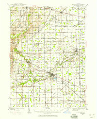 1939 Blissfield1958 Print · USGSSoutheastern Michigan agriculture and industry are in full view during the late 1930s as a dense network of railroads and rivers connects small farm towns. Local historians can trace the locations of dozens of vanished schools like Ford Sch and rail junctions like Lenawee Junction.
End of results
Showing maps 1-1 of 1
Top cities near Palmyra Township
- Adrian historical maps
- Sylvania historical maps
- York Charter Township historical maps
- Tecumseh historical maps
- Whiteford Township historical maps
- Manchester Township historical maps
See more
Top neighborhoods of Palmyra Township
- Lenawee Junction historical maps
- Wellsville historical maps
- Palmyra historical maps
- Ogden historical maps
Frequently asked questions
- What are the different types of historical maps available for Palmyra Township?
- What is the oldest map of Palmyra Township?
- Where can I purchase historical maps of Palmyra Township for my home or office?
- Where can I download high-res historical maps of Palmyra Township?
- Are there historical topographic maps available for Palmyra Township?
- Is there historical aerial imagery available for Palmyra Township?
- Where are historical maps of Palmyra Township sourced from?