1940s Maps of Holmes Township, Michigan
Explore 4 historic maps of Holmes Township from the 1940s. These maps offer a rare glimpse into what life looked like during the 1940s — showing old roads, neighborhoods, homes, and landmarks that have changed or disappeared over time.
Whether you're researching your family's past, planning a metal detecting trip, or studying how Holmes Township's landscape evolved across the 1940s, these high-resolution maps are a powerful tool for exploring the history of this region.
- Focus on a specific era: All maps on this page are from the 1940s, giving you a focused view of this time period.
- See what’s changed: Compare century-old streets, trails, and buildings to today's modern landscape using overlays and satellite layers.
- Research with precision: Use these maps for genealogy, historical research, land use analysis, or educational projects.
- View, download, or print: Maps are fully viewable online in high resolution, and can be downloaded or printed for your own records.
Start exploring Holmes Township's history through authentic maps from the 1940s. This is your window into the past.
Holmes Township, MI maps
(4)- 1942 Map of Wausaukee
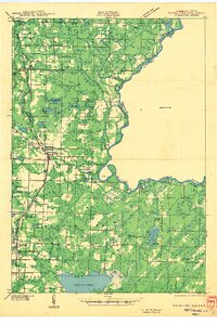 1942 Wausaukee1942 Print · USGSMarinette County in the early 1940s was a landscape of timber-towns and railroads winding toward the Michigan border. Genealogists can locate family-named rural schools like Shanebrook Sch and Gallow Sch or trace the early community at WAUSAUKEE.
 - 1947 Map of Pembine
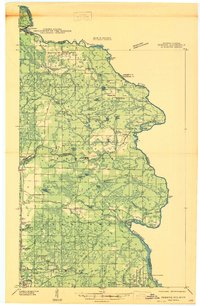 1947 Pembine1947 Print · USGSMarinette County was a landscape of stone quarries and timber-line railroads just after World War II. Researchers can trace rural life through sites like Dixon Sch, the Reformatory Quarry, and the Mission Chapel near Kremlin.
 - 1947 Map of Wausaukee
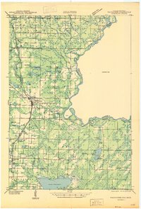 1947 Wausaukee1947 Print · USGSMarinette County in the late nineteen-forties centers on the village of Wausaukee and its surrounding glacial lake country. Trace the locations of rural schoolhouses like Shanebrook Sch and Gallow Sch, or locate family sites near Cedarville and the Pine Hill Cem.
 - 1949 Map of Stephenson
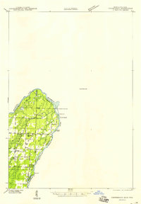 1949 Stephenson1949 Print · USGSThe Menominee River borderlands are shown in detail during the late 1940s, highlighting the transition from timber extraction to settled rural life. Researchers can trace the Old Logging Railroad Grade and locate community landmarks like the McAllister Sch and Goll Cem.
End of results
Showing maps 1-4 of 4
Top cities near Holmes Township
- Spalding historical maps
- Nadeau historical maps
- Pembine historical maps
- Amberg historical maps
- Stephenson historical maps
- Wagner historical maps
See more
Top neighborhoods of Holmes Township
Frequently asked questions
- What are the different types of historical maps available for Holmes Township?
- What is the oldest map of Holmes Township?
- Where can I purchase historical maps of Holmes Township for my home or office?
- Where can I download high-res historical maps of Holmes Township?
- Are there historical topographic maps available for Holmes Township?
- Is there historical aerial imagery available for Holmes Township?
- Where are historical maps of Holmes Township sourced from?