1970s Maps of Fruitport Charter Township, Michigan
Explore 4 historic maps of Fruitport Charter Township from the 1970s. These maps offer a rare glimpse into what life looked like during the 1970s — showing old roads, neighborhoods, homes, and landmarks that have changed or disappeared over time.
Whether you're researching your family's past, planning a metal detecting trip, or studying how Fruitport Charter Township's landscape evolved across the 1970s, these high-resolution maps are a powerful tool for exploring the history of this region.
- Focus on a specific era: All maps on this page are from the 1970s, giving you a focused view of this time period.
- See what’s changed: Compare century-old streets, trails, and buildings to today's modern landscape using overlays and satellite layers.
- Research with precision: Use these maps for genealogy, historical research, land use analysis, or educational projects.
- View, download, or print: Maps are fully viewable online in high resolution, and can be downloaded or printed for your own records.
Start exploring Fruitport Charter Township's history through authentic maps from the 1970s. This is your window into the past.
Fruitport Charter Township, MI maps
(4)- 1972 Map of Sullivan, 1975 Print
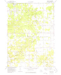 1972 Sullivan1975 Print · USGSMuskegon County is captured here in the early seventies, showing the transition from agricultural land to growing residential pockets. Researchers can find Township Cem, the Landing Field (Abandoned), and the crossing of the Penn Central railroad.2 unique versions available
 - 1972 Map of Grand Haven, 1975 Print
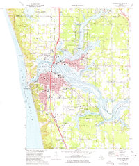 1972 Grand Haven1975 Print · USGSGrand Haven and the lower Grand River are shown in the early seventies during a period of established lakeside industry and recreation. Researchers can trace local genealogy and land use through features like Lake Forest Cemetery, Nortonville Chapel, and the Grand Haven Memorial Airpark.3 unique versions available
 - 1972 Map of Nunica, 1975 Print
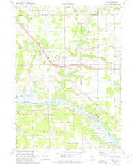 1972 Nunica1975 Print · USGSThe Grand River valley in the early seventies shows a landscape of bayous and transit routes just inland from the lake. Researchers can find many rural landmarks, from Nunica Cem and Grace Ch to the Jablonski Landing Field and the Grand Trunk Western rail line.
 - 1972 Map of Muskegon East, 1975 Print
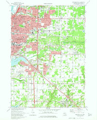 1972 Muskegon East1975 Print · USGSMuskegon and its southern lakefront suburbs reached a peak of mid-century development in the early seventies. Genealogists and researchers can trace family roots through numerous parish schools like Sacred Heart Sch and several local burial grounds including Mona View Cemetery.2 unique versions available
End of results
Showing maps 1-4 of 4
Top cities near Fruitport Charter Township
- Muskegon historical maps
- Norton Shores historical maps
- Spring Lake Township historical maps
- Muskegon Heights historical maps
- Grand Haven historical maps
- Dalton historical maps
See more
Top neighborhoods of Fruitport Charter Township
Frequently asked questions
- What are the different types of historical maps available for Fruitport Charter Township?
- What is the oldest map of Fruitport Charter Township?
- Where can I purchase historical maps of Fruitport Charter Township for my home or office?
- Where can I download high-res historical maps of Fruitport Charter Township?
- Are there historical topographic maps available for Fruitport Charter Township?
- Is there historical aerial imagery available for Fruitport Charter Township?
- Where are historical maps of Fruitport Charter Township sourced from?