1980s Maps of Interior Township, Michigan
Explore 7 historic maps of Interior Township from the 1980s. These maps offer a rare glimpse into what life looked like during the 1980s — showing old roads, neighborhoods, homes, and landmarks that have changed or disappeared over time.
Whether you're researching your family's past, planning a metal detecting trip, or studying how Interior Township's landscape evolved across the 1980s, these high-resolution maps are a powerful tool for exploring the history of this region.
- Focus on a specific era: All maps on this page are from the 1980s, giving you a focused view of this time period.
- See what’s changed: Compare century-old streets, trails, and buildings to today's modern landscape using overlays and satellite layers.
- Research with precision: Use these maps for genealogy, historical research, land use analysis, or educational projects.
- View, download, or print: Maps are fully viewable online in high resolution, and can be downloaded or printed for your own records.
Start exploring Interior Township's history through authentic maps from the 1980s. This is your window into the past.
Interior Township, MI maps
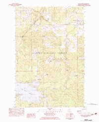
(7)- 1982 Map of Sparrow Rapids, 1983 Print
 1982 Sparrow Rapids1983 Print · USGSIn the early eighties, this stretch of the Upper Peninsula was a landscape of dense timber and winding waterways along the East Branch Ontonagon River. Genealogists and historians can trace the paths of an Old RR Grade and find early recreational landmarks like the Sparrow Rapids Campground and Onion Falls.
 - 1982 Map of Lake Mitigwaki, 1983 Print
 1982 Lake Mitigwaki1983 Print · USGSUpper Peninsula wilderness in the early eighties is defined here by the dense hydrology of the Ottawa National Forest. You can trace the Chicago and North Western rail line and locate remote features like Bear Trap Dam and Lake Mitigwaki.
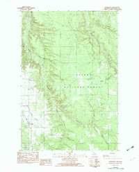
 - 1982 Map of Kenton, 1983 Print
 1982 Kenton1983 Print · USGSUpper Peninsula timber and river lands come into focus during the early eighties, centered on the settlement of Kenton. Researchers can trace the Old RR Grade through the Ottawa National Forest and locate family landmarks like the local Cem or the camps near Tepee Lake.
 - 1982 Map of Trout Creek, 1983 Print
 1982 Trout Creek1983 Print · USGSOntonagon County in the early 1980s shows a landscape of timber and water, centered on the Soo Line rail corridor. Researchers can trace historic sites like the Agate Cem, the Gospel Mission Ch, and the rugged Bond Falls Flowage.
 - 1982 Map of Paynesville, 1983 Print
 1982 Paynesville1983 Print · USGSThe Upper Peninsula wilderness of Ontonagon County is documented here during the early eighties as the Ottawa National Forest surrounds small timber-country outposts. Researchers can trace the layout of Paynesville, find the Mile and One-half Line, and locate Jack Pine Lake.
 - 1982 Map of Fuller, 1983 Print
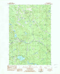 1982 Fuller1983 Print · USGSThe northern Michigan wilderness at the turn of the 1980s reveals a landscape shaped by timber and water. Genealogists and researchers can trace the remnants of earlier years at Interior Cem, Interior Sta, and the Burned Dam Camp.
 - 1989 Map of Iron River, 1990 Print
 1989 Iron River1990 Print · USGSUpper Peninsula mining and timber lands are documented here in the late 1980s, showcasing the region's industrial and natural interface. Researchers can trace the iron heritage through the Monongahela Mine and local junctions like Kelso Junction and Amasa.
End of results
Showing maps 1-7 of 7
Top cities near Interior Township
Top neighborhoods of Interior Township
Frequently asked questions
- What are the different types of historical maps available for Interior Township?
- What is the oldest map of Interior Township?
- Where can I purchase historical maps of Interior Township for my home or office?
- Where can I download high-res historical maps of Interior Township?
- Are there historical topographic maps available for Interior Township?
- Is there historical aerial imagery available for Interior Township?
- Where are historical maps of Interior Township sourced from?