1970s Maps of Ottawa Center, Crockery Township
Explore 1 historic maps of Ottawa Center from the 1970s. These maps offer a rare glimpse into what life looked like during the 1970s — showing old roads, neighborhoods, homes, and landmarks that have changed or disappeared over time.
Whether you're researching your family's past, planning a metal detecting trip, or studying how Ottawa Center's landscape evolved across the 1970s, these high-resolution maps are a powerful tool for exploring the history of this region.
- Focus on a specific era: All maps on this page are from the 1970s, giving you a focused view of this time period.
- See what’s changed: Compare century-old streets, trails, and buildings to today's modern landscape using overlays and satellite layers.
- Research with precision: Use these maps for genealogy, historical research, land use analysis, or educational projects.
- View, download, or print: Maps are fully viewable online in high resolution, and can be downloaded or printed for your own records.
Start exploring Ottawa Center's history through authentic maps from the 1970s. This is your window into the past.
Ottawa Center, Crockery Township maps
(1)- 1972 Map of Nunica, 1975 Print
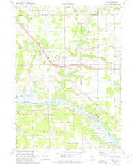 1972 Nunica1975 Print · USGSThe Grand River valley in the early seventies shows a landscape of bayous and transit routes just inland from the lake. Researchers can find many rural landmarks, from Nunica Cem and Grace Ch to the Jablonski Landing Field and the Grand Trunk Western rail line.
End of results
Showing maps 1-1 of 1
Top cities near Ottawa Center
- Muskegon historical maps
- Norton Shores historical maps
- Spring Lake Township historical maps
- Muskegon Heights historical maps
- Grand Haven historical maps
- Jamestown historical maps
See more
Frequently asked questions
- What are the different types of historical maps available for Ottawa Center?
- What is the oldest map of Ottawa Center?
- Where can I purchase historical maps of Ottawa Center for my home or office?
- Where can I download high-res historical maps of Ottawa Center?
- Are there historical topographic maps available for Ottawa Center?
- Is there historical aerial imagery available for Ottawa Center?
- Where are historical maps of Ottawa Center sourced from?