1960s Maps of Casco Township, Michigan
Explore 6 historic maps of Casco Township from the 1960s. These maps offer a rare glimpse into what life looked like during the 1960s — showing old roads, neighborhoods, homes, and landmarks that have changed or disappeared over time.
Whether you're researching your family's past, planning a metal detecting trip, or studying how Casco Township's landscape evolved across the 1960s, these high-resolution maps are a powerful tool for exploring the history of this region.
- Focus on a specific era: All maps on this page are from the 1960s, giving you a focused view of this time period.
- See what’s changed: Compare century-old streets, trails, and buildings to today's modern landscape using overlays and satellite layers.
- Research with precision: Use these maps for genealogy, historical research, land use analysis, or educational projects.
- View, download, or print: Maps are fully viewable online in high resolution, and can be downloaded or printed for your own records.
Start exploring Casco Township's history through authentic maps from the 1960s. This is your window into the past.
Casco Township, MI maps
(6)- 1961 Map of Detroit, 1973 Print
 1961 Detroit1973 Print · USGSThe international border between Michigan and Ontario was a bustling industrial corridor in the early sixties. Researchers can trace the transit networks and riverfront infrastructure connecting Detroit to Windsor via the Detroit-Windsor Tunnel and major air hubs like Willow Run Airport.2 unique versions available
 - 1965 Map of Detroit
 1965 Detroit1965 Print · USGSThe industrial corridor between Michigan and Ontario is captured here at mid-century, showing the dense rail and river networks of the Great Lakes. Local historians can trace the paths of the Grand Trunk Western RR and locate key landmarks like Selfridge Air Force Base and Grosse Ile.
 - 1968 Map of New Baltimore, 1971 Print
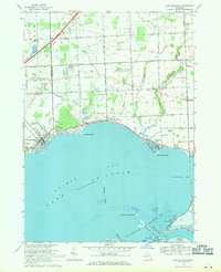 1968 New Baltimore1971 Print · USGSNorthern Lake St. Clair coastal life is captured here in the late sixties as residential expansion meets industrial utility. Genealogists and local historians can locate Sacred Heart Cem, the Motor City Drag Strip, and Fair Haven Sch.2 unique versions available
 - 1968 Map of Rattle Run, 1971 Print
 1968 Rattle Run1971 Print · USGSSt. Clair County in the late sixties shows a transition from traditional riverside milling to a complex landscape of oil fields and gas storage. Researchers can trace family roots through St Marys Cem or locate the historic Belle River Mills and Baird.
 - 1968 Map of Marine City, 1971 Print
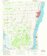 1968 Marine City1971 Print · USGSThe St. Clair River shoreline in the late sixties reveals a busy maritime and industrial landscape at the international border. Genealogists and historians can trace family-named sites like Roberts Landing or locate landmarks such as the Holy Cross Cem and the Marine City Airport.4 unique versions available
 - 1968 Map of Adair, 1971 Print
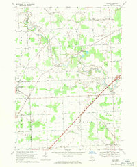 1968 Adair1971 Print · USGSThe rural landscapes of St. Clair and Macomb counties come alive in this late-sixties study of the area between the Belle and Puttygut rivers. Genealogists can trace family footprints through numerous cemeteries like Kittridge Cem and vanished landmarks in Muttonville and Snyderville.3 unique versions available
End of results
Showing maps 1-6 of 6
Top cities near Casco Township
- Clinton Township historical maps
- Macomb Township historical maps
- Chesterfield Township historical maps
- Port Huron historical maps
- Harrison Township historical maps
- Mount Clemens historical maps
See more
Top neighborhoods of Casco Township
Frequently asked questions
- What are the different types of historical maps available for Casco Township?
- What is the oldest map of Casco Township?
- Where can I purchase historical maps of Casco Township for my home or office?
- Where can I download high-res historical maps of Casco Township?
- Are there historical topographic maps available for Casco Township?
- Is there historical aerial imagery available for Casco Township?
- Where are historical maps of Casco Township sourced from?