1960s Maps of Forester Township, Michigan
Explore 4 historic maps of Forester Township from the 1960s. These maps offer a rare glimpse into what life looked like during the 1960s — showing old roads, neighborhoods, homes, and landmarks that have changed or disappeared over time.
Whether you're researching your family's past, planning a metal detecting trip, or studying how Forester Township's landscape evolved across the 1960s, these high-resolution maps are a powerful tool for exploring the history of this region.
- Focus on a specific era: All maps on this page are from the 1960s, giving you a focused view of this time period.
- See what’s changed: Compare century-old streets, trails, and buildings to today's modern landscape using overlays and satellite layers.
- Research with precision: Use these maps for genealogy, historical research, land use analysis, or educational projects.
- View, download, or print: Maps are fully viewable online in high resolution, and can be downloaded or printed for your own records.
Start exploring Forester Township's history through authentic maps from the 1960s. This is your window into the past.
Forester Township, MI maps
(4)- 1963 Map of Port Sanilac, 1964 Print
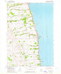 1963 Port Sanilac1964 Print · USGSThe Lake Huron shoreline of Sanilac County is captured here in the early 1960s, showing a landscape of lakeside villages and inland family farms. Researchers can locate specific sites like the Port Sanilac Lighthouse, the Cottage Sch, and several rural burial grounds including St Marys Cem.
 - 1963 Map of Deckerville, 1964 Print
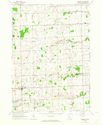 1963 Deckerville1964 Print · USGSSanilac County's agricultural heartland is documented here in the early sixties, centered on the rail-aligned village of Deckerville. Researchers can trace old family sites and rural institutions like St Johns Ch, Delaware Cem, and the Hunt Sch.
 - 1963 Map of Richmondville, 1964 Print
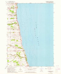 1963 Richmondville1964 Print · USGSThe Michigan shoreline of Sanilac County is captured here in the early 1960s, showing the quiet coastal life of the thumb region. Researchers can trace local landmarks from the Richmondville settlement to the Landing Field and the small Cemetery near Delaware.
 - 1963 Map of Carsonville, 1964 Print
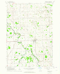 1963 Carsonville1964 Print · USGSSanilac County's agricultural heartland is captured here in the early sixties, centered on the rail hub of Carsonville. Researchers can trace old family footprints through numerous township sites, including Zion Cem, Baker Sch, and the local Drive-in Theater.2 unique versions available
End of results
Showing maps 1-4 of 4
Top cities near Forester Township
- Sandusky historical maps
- Forester historical maps
- Deckerville historical maps
- Port Sanilac historical maps
- Carsonville historical maps
- Applegate historical maps
See more
Top neighborhoods of Forester Township
Frequently asked questions
- What are the different types of historical maps available for Forester Township?
- What is the oldest map of Forester Township?
- Where can I purchase historical maps of Forester Township for my home or office?
- Where can I download high-res historical maps of Forester Township?
- Are there historical topographic maps available for Forester Township?
- Is there historical aerial imagery available for Forester Township?
- Where are historical maps of Forester Township sourced from?