1960s Maps of Augusta Charter Township, Michigan
Explore 6 historic maps of Augusta Charter Township from the 1960s. These maps offer a rare glimpse into what life looked like during the 1960s — showing old roads, neighborhoods, homes, and landmarks that have changed or disappeared over time.
Whether you're researching your family's past, planning a metal detecting trip, or studying how Augusta Charter Township's landscape evolved across the 1960s, these high-resolution maps are a powerful tool for exploring the history of this region.
- Focus on a specific era: All maps on this page are from the 1960s, giving you a focused view of this time period.
- See what’s changed: Compare century-old streets, trails, and buildings to today's modern landscape using overlays and satellite layers.
- Research with precision: Use these maps for genealogy, historical research, land use analysis, or educational projects.
- View, download, or print: Maps are fully viewable online in high resolution, and can be downloaded or printed for your own records.
Start exploring Augusta Charter Township's history through authentic maps from the 1960s. This is your window into the past.
Augusta Charter Township, MI maps
(6)- 1961 Map of Detroit, 1973 Print
 1961 Detroit1973 Print · USGSThe international border between Michigan and Ontario was a bustling industrial corridor in the early sixties. Researchers can trace the transit networks and riverfront infrastructure connecting Detroit to Windsor via the Detroit-Windsor Tunnel and major air hubs like Willow Run Airport.2 unique versions available
 - 1965 Map of Detroit
 1965 Detroit1965 Print · USGSThe industrial corridor between Michigan and Ontario is captured here at mid-century, showing the dense rail and river networks of the Great Lakes. Local historians can trace the paths of the Grand Trunk Western RR and locate key landmarks like Selfridge Air Force Base and Grosse Ile.
 - 1967 Map of Ypsilanti West, 1969 Print
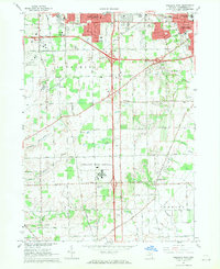 1967 Ypsilanti West1969 Print · USGSWashtenaw County's transition from agricultural townships to suburban suburbs is documented here in the late sixties. Researchers can trace the massive footprint of the Ypsilanti State Hospital and find local landmarks like the York Cem and Stone Sch.4 unique versions available
 - 1967 Map of Maybee, 1969 Print
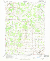 1967 Maybee1969 Print · USGSSoutheast Michigan’s agricultural heartland is mapped here in the late sixties, where family-named drains and county lines converge. Researchers can trace the Old Indian Treaty Boundary and locate family history at Bethlehem Ch, St Josephs Cem, or the Brainard Sch.
 - 1967 Map of Milan, 1970 Print
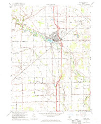 1967 Milan1970 Print · USGSSoutheast Michigan in the late sixties reveals a landscape of thriving township centers and sprawling agricultural drains. Genealogists and local historians can trace family plots at Marble Park Cemetery or follow the historic Old Indian Treaty Boundary near Azalia.2 unique versions available
 - 1967 Map of Ypsilanti East, 1974 Print
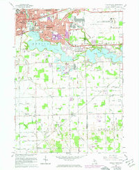 1967 Ypsilanti East1974 Print · USGSThe Ypsilanti area during the early seventies shows a landscape shifting from traditional agriculture to a major aviation and industrial hub. Researchers can trace the development of WILLOW RUN AIRPORT, find local schools like Erickson Sch, and locate rural landmarks such as Friends Ch.3 unique versions available
End of results
Showing maps 1-6 of 6
Top cities near Augusta Charter Township
- Ann Arbor historical maps
- Canton Charter Township historical maps
- Canton Township historical maps
- Livonia historical maps
- Westland historical maps
- Ypsilanti Charter Township historical maps
See more
Top neighborhoods of Augusta Charter Township
- Paint Creek historical maps
- Whittaker historical maps
- Willis historical maps
- Stony Creek historical maps
- Lincoln historical maps
Frequently asked questions
- What are the different types of historical maps available for Augusta Charter Township?
- What is the oldest map of Augusta Charter Township?
- Where can I purchase historical maps of Augusta Charter Township for my home or office?
- Where can I download high-res historical maps of Augusta Charter Township?
- Are there historical topographic maps available for Augusta Charter Township?
- Is there historical aerial imagery available for Augusta Charter Township?
- Where are historical maps of Augusta Charter Township sourced from?