1990s Maps of Paint Creek, Augusta Charter Township
Explore 1 historic maps of Paint Creek from the 1990s. These maps offer a rare glimpse into what life looked like during the 1990s — showing old roads, neighborhoods, homes, and landmarks that have changed or disappeared over time.
Whether you're researching your family's past, planning a metal detecting trip, or studying how Paint Creek's landscape evolved across the 1990s, these high-resolution maps are a powerful tool for exploring the history of this region.
- Focus on a specific era: All maps on this page are from the 1990s, giving you a focused view of this time period.
- See what’s changed: Compare century-old streets, trails, and buildings to today's modern landscape using overlays and satellite layers.
- Research with precision: Use these maps for genealogy, historical research, land use analysis, or educational projects.
- View, download, or print: Maps are fully viewable online in high resolution, and can be downloaded or printed for your own records.
Start exploring Paint Creek's history through authentic maps from the 1990s. This is your window into the past.
Paint Creek, Augusta Charter Township maps
(1)- 1996 Map of Ypsilanti East, 2000 Print
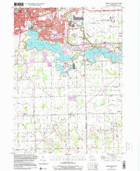 1996 Ypsilanti East2000 Print · USGSThe Huron River valley transitions from a busy college town to a landscape of massive aviation and research hubs during the mid-1990s. Genealogists and local historians can trace the development of Rawsonville or locate landmarks like Woodlawn Cem and Friends Ch south of Ford Lake.
End of results
Showing maps 1-1 of 1
Top cities near Paint Creek
- Ann Arbor historical maps
- Canton Township historical maps
- Canton Charter Township historical maps
- Livonia historical maps
- Westland historical maps
- Ypsilanti Charter Township historical maps
See more
Frequently asked questions
- What are the different types of historical maps available for Paint Creek?
- What is the oldest map of Paint Creek?
- Where can I purchase historical maps of Paint Creek for my home or office?
- Where can I download high-res historical maps of Paint Creek?
- Are there historical topographic maps available for Paint Creek?
- Is there historical aerial imagery available for Paint Creek?
- Where are historical maps of Paint Creek sourced from?