1930s Maps of Livonia, Michigan
Explore 4 historic maps of Livonia from the 1930s. These maps offer a rare glimpse into what life looked like during the 1930s — showing old roads, neighborhoods, homes, and landmarks that have changed or disappeared over time.
Whether you're researching your family's past, planning a metal detecting trip, or studying how Livonia's landscape evolved across the 1930s, these high-resolution maps are a powerful tool for exploring the history of this region.
- Focus on a specific era: All maps on this page are from the 1930s, giving you a focused view of this time period.
- See what’s changed: Compare century-old streets, trails, and buildings to today's modern landscape using overlays and satellite layers.
- Research with precision: Use these maps for genealogy, historical research, land use analysis, or educational projects.
- View, download, or print: Maps are fully viewable online in high resolution, and can be downloaded or printed for your own records.
Start exploring Livonia's history through authentic maps from the 1930s. This is your window into the past.
Livonia, MI maps
(4)- 1936 Map of Inkster
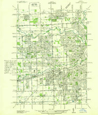 1936 Inkster1936 Print · USGSWestern Wayne County was a landscape of institutions and early aviation in the years before the war. Researchers can trace the legacy of the Eloise Hospital and Infirmary, locate local landmarks like Wankin Mills, or find family roots near Perrinsville and St Marys Cem.
 - 1936 Map of Wayne
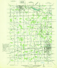 1936 Wayne1936 Print · USGSWestern Wayne County is seen here during the mid-1930s, showing the early suburban development between Plymouth and Wayne. Researchers can trace old property contexts and local landmarks like the Triangle Airport, Cadillac Mem Park Cem, and numerous country schools including Washington Sch.
 - 1936 Map of Redford
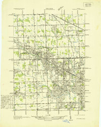 1936 Redford1936 Print · USGSNorthwestern Detroit suburbs emerge from farm tracts during the mid-1930s, showing early neighborhoods and grid-road expansion. Genealogists can find numerous burial grounds like Grand Lawn Cem and landmarks such as Bell Br Community Ch and the Redford Post Office.
 - 1936 Map of Northville
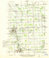 1936 Northville1936 Print · USGSNorthwest Wayne and southwest Oakland counties are captured here in the mid-1930s as the grid of mile roads and institutions matured. Researchers can trace family history at Rural Hill Cem or explore early landmarks like the US Fish Hatchery and Wayne County Training Sch.
End of results
Showing maps 1-4 of 4
Top cities near Livonia
- Detroit historical maps
- Canton Charter Township historical maps
- Canton Township historical maps
- Dearborn historical maps
- Troy historical maps
- Westland historical maps
See more
Top neighborhoods of Livonia
Frequently asked questions
- What are the different types of historical maps available for Livonia?
- What is the oldest map of Livonia?
- Where can I purchase historical maps of Livonia for my home or office?
- Where can I download high-res historical maps of Livonia?
- Are there historical topographic maps available for Livonia?
- Is there historical aerial imagery available for Livonia?
- Where are historical maps of Livonia sourced from?