1930s Maps of South Branch Township, Michigan
Explore 2 historic maps of South Branch Township from the 1930s. These maps offer a rare glimpse into what life looked like during the 1930s — showing old roads, neighborhoods, homes, and landmarks that have changed or disappeared over time.
Whether you're researching your family's past, planning a metal detecting trip, or studying how South Branch Township's landscape evolved across the 1930s, these high-resolution maps are a powerful tool for exploring the history of this region.
- Focus on a specific era: All maps on this page are from the 1930s, giving you a focused view of this time period.
- See what’s changed: Compare century-old streets, trails, and buildings to today's modern landscape using overlays and satellite layers.
- Research with precision: Use these maps for genealogy, historical research, land use analysis, or educational projects.
- View, download, or print: Maps are fully viewable online in high resolution, and can be downloaded or printed for your own records.
Start exploring South Branch Township's history through authentic maps from the 1930s. This is your window into the past.
South Branch Township, MI maps
(2)- 1933 Map of Peacock NE
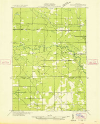 1933 Peacock NE1933 Print · USGSNorthern Michigan's forest and river country is captured here during the early 1930s as modern highways and power lines first cut through the woods. Genealogists and local historians can locate the Choker Cem and trace the footprints of the Hoxeyville Sch and Town Hall.
 - 1933 Map of Luther NW
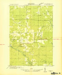 1933 Luther NW1933 Print · USGSIn the 1930s, the Pine River valley in Wexford County was a landscape of small crossroads and rural schools. Genealogists can trace the rural landscape of Hoxeyville, locating the Clay Hill Ch, the Banker Sch, and the riverside bends of the Pine River.
End of results
Showing maps 1-2 of 2
Top cities near South Branch Township
- Boon historical maps
- Mesick historical maps
- Peacock historical maps
- Marilla historical maps
- Luther historical maps
- Wellston historical maps
See more
Top neighborhoods of South Branch Township
Frequently asked questions
- What are the different types of historical maps available for South Branch Township?
- What is the oldest map of South Branch Township?
- Where can I purchase historical maps of South Branch Township for my home or office?
- Where can I download high-res historical maps of South Branch Township?
- Are there historical topographic maps available for South Branch Township?
- Is there historical aerial imagery available for South Branch Township?
- Where are historical maps of South Branch Township sourced from?