1960s Maps of Idun Township, Minnesota
Explore 2 historic maps of Idun Township from the 1960s. These maps offer a rare glimpse into what life looked like during the 1960s — showing old roads, neighborhoods, homes, and landmarks that have changed or disappeared over time.
Whether you're researching your family's past, planning a metal detecting trip, or studying how Idun Township's landscape evolved across the 1960s, these high-resolution maps are a powerful tool for exploring the history of this region.
- Focus on a specific era: All maps on this page are from the 1960s, giving you a focused view of this time period.
- See what’s changed: Compare century-old streets, trails, and buildings to today's modern landscape using overlays and satellite layers.
- Research with precision: Use these maps for genealogy, historical research, land use analysis, or educational projects.
- View, download, or print: Maps are fully viewable online in high resolution, and can be downloaded or printed for your own records.
Start exploring Idun Township's history through authentic maps from the 1960s. This is your window into the past.
Idun Township, MN maps
(2)- 1968 Map of Isle, 1970 Print
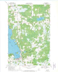 1968 Isle1970 Print · USGSThe southeast corner of Mille Lacs Lake thrived in the late sixties as a crossroads of rail travel and lakeside recreation. Genealogists and local historians can trace the foundations of Isle, find remote country stops like Opstead, and locate family burial sites at Holden Cem and Redtop Cem.
 - 1968 Map of Mc Grath, 1970 Print
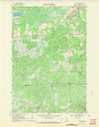 1968 Mc Grath1970 Print · USGSAitkin and Kanabec County in the late 1960s reveal a quiet landscape of wetlands and river bends centered on the SOO LINE railroad. Local researchers can trace family landmarks at Grace Cem or explore the early footprints of McGrath and Bergman.2 unique versions available
End of results
Showing maps 1-2 of 2
Top cities near Idun Township
- Isle historical maps
- Glen historical maps
- Malmo historical maps
- Wahkon historical maps
- McGrath historical maps
Top neighborhoods of Idun Township
Frequently asked questions
- What are the different types of historical maps available for Idun Township?
- What is the oldest map of Idun Township?
- Where can I purchase historical maps of Idun Township for my home or office?
- Where can I download high-res historical maps of Idun Township?
- Are there historical topographic maps available for Idun Township?
- Is there historical aerial imagery available for Idun Township?
- Where are historical maps of Idun Township sourced from?