Old Maps of Wyoming, Minnesota
Explore 13 old maps of Wyoming, spanning from 1953 to today. These high-resolution historic maps reveal how streets, neighborhoods, landmarks, and natural features evolved over time — perfect for genealogy, metal detecting, research, and local history exploration.
What you can do with these maps:
- See how Wyoming changed over time: Compare historical maps to modern-day views to trace roads, homesites, rail lines & more.
- View detailed metadata: Each map includes creators, publishers, year, scale, and archive source.
- Overlay maps with satellite & LiDAR: Visualize the past alongside modern tools to explore terrain & human change.
- Trusted historical sources: Maps sourced from the USGS, Library of Congress, and other archives.
- Access maps your way: View online, download high-res files, or order prints for personal or research use.
Start exploring old maps of Wyoming to uncover forgotten places, hidden landmarks, and the deep history beneath your feet.
Wyoming, MN maps
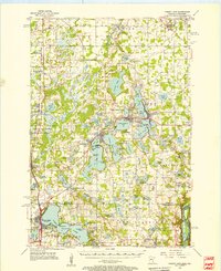
(13)- 1953 Map of Stillwater, 1980 Print
 1953 Stillwater1980 Print · USGSCovers Wyoming, including Minneapolis, Brooklyn Park, and other nearby areas
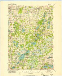
 - 1955 Map of Forest Lake, 1957 Print
 1955 Forest Lake1957 Print · USGSCovers Wyoming, including North Branch, Chisago City, and other nearby areas3 unique versions available
 - 1955 Map of Isanti, 1957 Print
 1955 Isanti1957 Print · USGSCovers Wyoming, including Ham Lake, East Bethel, and other nearby areas2 unique versions available
 - 1955 Map of Stillwater, 1965 Print
 1955 Stillwater1965 Print · USGSCovers Wyoming, including Minneapolis, Brooklyn Park, and other nearby areas
 - 1958 Map of Stillwater
 1958 Stillwater1958 Print · USGSCovers Wyoming, including Minneapolis, Brooklyn Park, and other nearby areas2 unique versions available
 - 1965 Map of Stillwater
 1965 Stillwater1965 Print · USGSCovers Wyoming, including Minneapolis, Brooklyn Park, and other nearby areas
 - 1974 Map of Stacy, 1976 Print
 1974 Stacy1976 Print · USGSCovers Wyoming, including North Branch, Chisago City, and other nearby areas
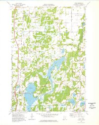
 - 1974 Map of Forest Lake, 1976 Print
 1974 Forest Lake1976 Print · USGSCovers Wyoming, including Chisago City, Stacy, and other nearby areas2 unique versions available
 - 1974 Map of Linwood, 1976 Print
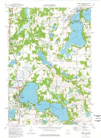
 1974 Linwood1976 Print · USGSCovers Wyoming, including Linwood, Columbus, and other nearby areas3 unique versions available
 - 1975 Map of Stillwater
 1975 Stillwater1975 Print · USGSCovers Wyoming, including Minneapolis, Brooklyn Park, and other nearby areas2 unique versions available
 - 1985 Map of Stillwater
 1985 Stillwater1985 Print · USGSCovers Wyoming, including Maplewood, White Bear Lake, and other nearby areas2 unique versions available
 - 1985 Map of Anoka
 1985 Anoka1985 Print · USGSCovers Wyoming, including Minneapolis, Brooklyn Park, and other nearby areas
 - 1991 Map of Anoka, 1992 Print
 1991 Anoka1992 Print · USGSCovers Wyoming, including Minneapolis, Brooklyn Park, and other nearby areas
End of results
Showing maps 1-13 of 13
Top cities near Wyoming
- Blaine historical maps
- Shoreview historical maps
- Lino Lakes historical maps
- Ham Lake historical maps
- East Bethel historical maps
- Mounds View historical maps
See more
Top neighborhoods of Wyoming
Frequently asked questions
- What are the different types of historical maps available for Wyoming?
- What is the oldest map of Wyoming?
- Where can I purchase historical maps of Wyoming for my home or office?
- Where can I download high-res historical maps of Wyoming?
- Are there historical topographic maps available for Wyoming?
- Is there historical aerial imagery available for Wyoming?
- Where are historical maps of Wyoming sourced from?