1960s Maps of Ulen, Minnesota
Explore 3 historic maps of Ulen from the 1960s. These maps offer a rare glimpse into what life looked like during the 1960s — showing old roads, neighborhoods, homes, and landmarks that have changed or disappeared over time.
Whether you're researching your family's past, planning a metal detecting trip, or studying how Ulen's landscape evolved across the 1960s, these high-resolution maps are a powerful tool for exploring the history of this region.
- Focus on a specific era: All maps on this page are from the 1960s, giving you a focused view of this time period.
- See what’s changed: Compare century-old streets, trails, and buildings to today's modern landscape using overlays and satellite layers.
- Research with precision: Use these maps for genealogy, historical research, land use analysis, or educational projects.
- View, download, or print: Maps are fully viewable online in high resolution, and can be downloaded or printed for your own records.
Start exploring Ulen's history through authentic maps from the 1960s. This is your window into the past.
Ulen, MN maps
(3)- 1966 Map of Grand Forks
 1966 Grand Forks1966 Print · USGSThe Red River Valley in the mid-sixties shows a landscape shaped by rail-line commerce and complex water management. Genealogists and historians can trace rail-side towns like Emerado and Hunter or locate rural landmarks like the Pleasant View Church.
 - 1966 Map of Tilde Lake, 1967 Print
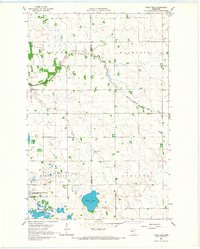 1966 Tilde Lake1967 Print · USGSThe borderlands of Clay and Becker counties come alive in the mid-1960s, showing a landscape of glacial lakes and prairie drainage. Researchers can trace rural life through the Atlanta Ch, the local Townhall, and the expansive Goose Prairie State Wildlife Management Area.
 - 1966 Map of Ulen, 1967 Print
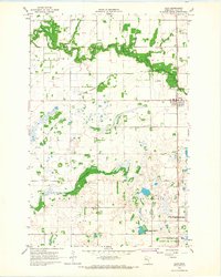 1966 Ulen1967 Print · USGSClay County prairie life in the sixties is centered on the railroad town of Ulen and the winding Wild Rice River. Genealogists and historians can trace local landmarks like Sleeper Cem, Keene Ch, and the tracks of the Northern Pacific.
End of results
Showing maps 1-3 of 3
Top cities near Ulen
- Hawley historical maps
- Lake Park historical maps
- Twin Valley historical maps
- Hitterdal historical maps
- Flom historical maps
- Fossum historical maps
Frequently asked questions
- What are the different types of historical maps available for Ulen?
- What is the oldest map of Ulen?
- Where can I purchase historical maps of Ulen for my home or office?
- Where can I download high-res historical maps of Ulen?
- Are there historical topographic maps available for Ulen?
- Is there historical aerial imagery available for Ulen?
- Where are historical maps of Ulen sourced from?