1900s (20th Century) Maps of Akeley, Minnesota
Explore 13 historic maps of Akeley from the 1900s (20th Century). These maps offer a rare glimpse into what life looked like during the 1900s — showing old roads, neighborhoods, homes, and landmarks that have changed or disappeared over time.
Whether you're researching your family's past, planning a metal detecting trip, or studying how Akeley's landscape evolved across the 1900s, these high-resolution maps are a powerful tool for exploring the history of this region.
- Focus on a specific era: All maps on this page are from the 1900s, giving you a focused view of this time period.
- See what’s changed: Compare century-old streets, trails, and buildings to today's modern landscape using overlays and satellite layers.
- Research with precision: Use these maps for genealogy, historical research, land use analysis, or educational projects.
- View, download, or print: Maps are fully viewable online in high resolution, and can be downloaded or printed for your own records.
Start exploring Akeley's history through authentic maps from the 1900s. This is your window into the past.
Akeley, MN maps
(13)- 1953 Map of Brainerd, 1966 Print
 1953 Brainerd1966 Print · USGSCentral Minnesota's lake country and iron ranges are detailed in the mid-fifties, showing the intersection of industry and wilderness. Researchers can locate specific local landmarks like the Crow Wing County Courthouse or trace the early paths of the Soo Line Railroad and the Cuyuna Range Iron Mines.3 unique versions available
 - 1954 Map of Bemidji, 1966 Print
 1954 Bemidji1966 Print · USGSNorthern Minnesota's lake country and timberlands are captured here at a mid-century peak of rail and road expansion. Genealogists and historians can trace family roots through numerous small settlements like Mahnomen, Clearbrook, and Walker, while locating local landmarks such as White Earth Church.4 unique versions available
 - 1957 Map of Brainerd
 1957 Brainerd1957 Print · USGSNorth-central Minnesota's lake-rich landscape is captured in the mid-1950s as a crossroads of rail, river, and forest. Genealogists and historians can trace the paths of the Great Northern and Soo Line railroads through hubs like Brainerd, Wadena, and Detroit Lakes.
 - 1957 Map of Bemidji
 1957 Bemidji1957 Print · USGSNorthern Minnesota in the mid-fifties is defined by its massive lake systems and the sprawling timberlands of the Chippewa National Forest. Genealogists and researchers can trace old rail lines like the Great Northern RR and locate settlements such as Moberg, Naytahwaush, and Lake Itasca.
 - 1958 Map of Bemidji
 1958 Bemidji1958 Print · USGSNorthern Minnesota in the late fifties is a vast landscape of tribal lands and timber forests tied together by rail. Genealogists and researchers can trace old rail stops and lakeside communities from Walker to Fosston, or explore the source of the Mississippi at Lake Itasca.
 - 1958 Map of Brainerd
 1958 Brainerd1958 Print · USGSCentral Minnesota in the late fifties is a landscape of dense lake chains, rail hubs, and sprawling state forests. Genealogists and local historians can trace old property alignments near the Mississippi River or locate family sites in Brainerd, Little Falls, and Detroit Lakes.
 - 1965 Map of Brainerd
 1965 Brainerd1965 Print · USGSNorth-central Minnesota in the mid-fifties presents a complex landscape of sprawling lake systems and established rail corridors. Genealogists and historians can trace the growth of timber towns along the Northern Pacific RR and explore early borders of the White Earth Indian Reservation or Tamarac National Wildlife Refuge.
 - 1970 Map of Crystal Lake, 1972 Print
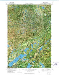
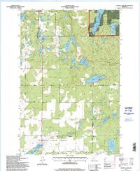
 1970 Crystal Lake1972 Print · USGSThe lake-strewn woods of Hubbard and Cass Counties are captured here in the early 1970s, showcasing a landscape defined by state and national forests. Genealogists and local historians can trace the sites of Akeley, Chamberlain, and the White Oak Cem.2 unique versions available
 - 1972 Map of Akeley, 1974 Print
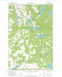
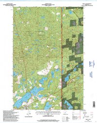
 1972 Akeley1974 Print · USGSAkeley and the surrounding lake country are shown in the early seventies as timber and recreation define the local economy. Trace the Burlington Northern rail line and explore lakeside landmarks like the Shingobee Ski Area and Eleventh Crow Wing Lake.
 - 1976 Map of Pine River, 1994 Print
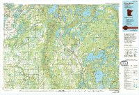 1976 Pine River1994 Print · USGSNorthern Minnesota's lake country is captured here during the mid-seventies, showing the expansion of recreation around Pequot Lakes and Nisswa. Researchers can trace the Burlington Northern rail line and locate forest landmarks within the Paul Bunyan State Forest and Chippewa National Forest.
 - 1977 Map of Cass Lake, 1978 Print
 1977 Cass Lake1978 Print · USGSThe northern Minnesota lake country is shown in the late seventies, dominated by the massive waters of Leech Lake and the headwaters of the Mississippi. Genealogists and local historians can trace lakeside settlements like Walker and Onigum, or locate the State College in Bemidji.
 - 1996 Map of Crystal Lake, 1998 Print
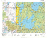
 1996 Crystal Lake1998 Print · USGSHubbard County in the 1990s was a landscape of dense state forests and glacial water bodies. Genealogists and local historians can trace family locations near Akeley or locate burial sites at Akeley Cemetery and White Oak Cemetery.
 - 1996 Map of Akeley, 1998 Print
 1996 Akeley1998 Print · USGSAkeley and the surrounding timberlands are shown in the mid-1990s as the regional economy transitioned toward recreation and forest management. Researchers can trace the path of the Heartland Trail and locate local landmarks like the Shingobee Recreation Area and Eleventh Crow Wing Lake.
End of results
Showing maps 1-13 of 13
Top cities near Akeley
- Walker historical maps
- Nevis historical maps
- Backus historical maps
- Hackensack historical maps
- Badoura historical maps
Frequently asked questions
- What are the different types of historical maps available for Akeley?
- What is the oldest map of Akeley?
- Where can I purchase historical maps of Akeley for my home or office?
- Where can I download high-res historical maps of Akeley?
- Are there historical topographic maps available for Akeley?
- Is there historical aerial imagery available for Akeley?
- Where are historical maps of Akeley sourced from?