2020s Maps of Crystal Bay Township, Minnesota
Explore 12 historic maps of Crystal Bay Township from the 2020s. These maps offer a rare glimpse into what life looked like during the 2020s — showing old roads, neighborhoods, homes, and landmarks that have changed or disappeared over time.
Whether you're researching your family's past, planning a metal detecting trip, or studying how Crystal Bay Township's landscape evolved across the 2020s, these high-resolution maps are a powerful tool for exploring the history of this region.
- Focus on a specific era: All maps on this page are from the 2020s, giving you a focused view of this time period.
- See what’s changed: Compare century-old streets, trails, and buildings to today's modern landscape using overlays and satellite layers.
- Research with precision: Use these maps for genealogy, historical research, land use analysis, or educational projects.
- View, download, or print: Maps are fully viewable online in high resolution, and can be downloaded or printed for your own records.
Start exploring Crystal Bay Township's history through authentic maps from the 2020s. This is your window into the past.
Crystal Bay Township, MN maps
(12)- 2022 Map of Doyle Lake, 2022 Print
 2022 Doyle Lake2022 Print · USGSThe settlement of Finland sits at the heart of this Lake County forest landscape in the 2020s. Researchers can trace the waterways of the Superior National Forest, including Doyle Lake, Hockamin Creek, and the E Br Baptism River.
 - 2022 Map of Illgen City, 2022 Print
 2022 Illgen City2022 Print · USGSThe dramatic North Shore of Lake County comes into focus in this modern survey of the shoreline. Researchers can trace the coastal layout of Illgen City and Silver Bay, locating Reider Silver Bay Cem and landmarks like Palisade Head.
 - 2022 Map of Isabella Lake, 2022 Print
 2022 Isabella Lake2022 Print · USGSLake County's wilderness is captured in the early 2020s, showing a landscape defined by the expansive Isabella Lake and the storied Powwow Trail. Researchers can trace the layout of Forest Center or follow the interconnected waters of the Isabella River and Island River.
 - 2022 Map of Finland, 2022 Print
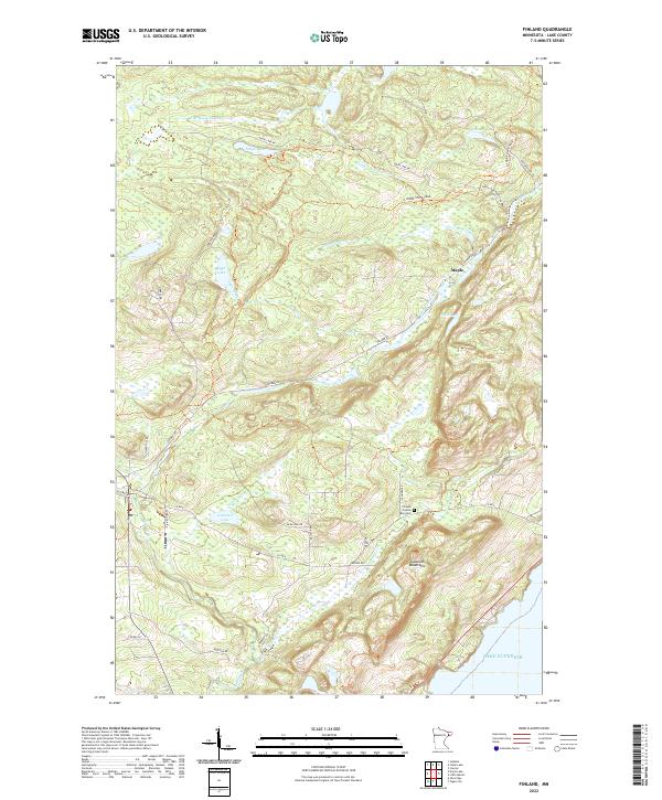 2022 Finland2022 Print · USGSThe Lake Superior shoreline meets the Sawtooth Mountains in the twenty-first century, revealing a landscape of high ridges and forest trails. Researchers can trace local landmarks like Finland Crystal Bay Cem, the N Shore State Trail, and the settlement at Maple.
 - 2022 Map of Silver Island Lake, 2022 Print
 2022 Silver Island Lake2022 Print · USGSLake County's wilderness is captured here in the early twenty-first century, showing the remote water-and-woods character of the Superior National Forest. Researchers can trace forest access routes like Trappers Lake and identify recreational points such as the Silver Island Boat Landing.
 - 2022 Map of Sawbill Landing, 2022 Print
 2022 Sawbill Landing2022 Print · USGSLake County's Northwoods come into sharp focus in the early 2020s, showcasing the intersection of timber management and recreation. You can trace modern forest routes like Sapphire Lake Rd and locate specific points of interest such as Sawbill Landing and Dumbbell Lake.
 - 2022 Map of Perent Lake, 2022 Print
 2022 Perent Lake2022 Print · USGSLake County's wilderness interior is documented here in the early 2020s, showing a complex landscape of glacial waters and forest routes. You can trace the winding course of the Island River or locate remote water bodies like Perent Lake and Warbler Lake.
 - 2022 Map of Alice Lake, 2022 Print
 2022 Alice Lake2022 Print · USGSThe wilderness of Lake County and the Superior National Forest are captured here in the early 2020s. Researchers can trace the ancient waterways of the Kawishiwi River and portages between Alice Lake, Thomas Lake, and Malberg Lake.
 - 2022 Map of Lake Insula, 2022 Print
 2022 Lake Insula2022 Print · USGSNorthern Minnesota’s backcountry is revealed in this modern wilderness survey of the Boundary Waters area. You can trace historic portages and hiking routes like the Kekekabic Trail as they weave between Lake Insula, Disappointment Mtn, and Hudson Lake.
 - 2022 Map of Isabella, 2022 Print
 2022 Isabella2022 Print · USGSLake County's timber and water networks are documented here in the early twenty-first century. Genealogists and local historians can trace the foundations of Isabella and Murphy City, or locate family sites near Isabella Memorial Cem and Manitou Junction.
 - 2022 Map of Silver Bay, 2022 Print
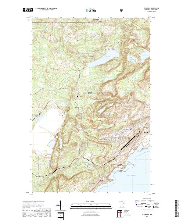 2022 Silver Bay2022 Print · USGSSilver Bay and the historic Beaver Bay area are shown in detail as they appeared in 2022 along the Lake Superior shoreline. Researchers can trace local history through the Sawtooth Mountain Cem, the cascades of Beaver River Falls, and landmarks like Mariner Mtn.
 - 2022 Map of Cabin Lake, 2022 Print
 2022 Cabin Lake2022 Print · USGSLake County, Minnesota, is shown here in the 2020s as a managed wilderness within the Superior National Forest. Researchers can trace forest access routes like Roger Koster Road and locate remote water bodies including Balsam Lake and Cabin Lake.
End of results
Showing maps 1-12 of 12
Top neighborhoods of Crystal Bay Township
- Finland historical maps
- Maple historical maps
- Manitou Junction historical maps
- Sawbill Landing historical maps
Frequently asked questions
- What are the different types of historical maps available for Crystal Bay Township?
- What is the oldest map of Crystal Bay Township?
- Where can I purchase historical maps of Crystal Bay Township for my home or office?
- Where can I download high-res historical maps of Crystal Bay Township?
- Are there historical topographic maps available for Crystal Bay Township?
- Is there historical aerial imagery available for Crystal Bay Township?
- Where are historical maps of Crystal Bay Township sourced from?