1960s Maps of Onamia Township, Minnesota
Explore 5 historic maps of Onamia Township from the 1960s. These maps offer a rare glimpse into what life looked like during the 1960s — showing old roads, neighborhoods, homes, and landmarks that have changed or disappeared over time.
Whether you're researching your family's past, planning a metal detecting trip, or studying how Onamia Township's landscape evolved across the 1960s, these high-resolution maps are a powerful tool for exploring the history of this region.
- Focus on a specific era: All maps on this page are from the 1960s, giving you a focused view of this time period.
- See what’s changed: Compare century-old streets, trails, and buildings to today's modern landscape using overlays and satellite layers.
- Research with precision: Use these maps for genealogy, historical research, land use analysis, or educational projects.
- View, download, or print: Maps are fully viewable online in high resolution, and can be downloaded or printed for your own records.
Start exploring Onamia Township's history through authentic maps from the 1960s. This is your window into the past.
Onamia Township, MN maps
(5)- 1965 Map of Stillwater
 1965 Stillwater1965 Print · USGSThe Twin Cities and the St. Croix Valley are mapped here during a period of significant post-war growth and industrial transit. Genealogists and historians can trace rail lines like the Northern Pacific RR through towns such as Rush City, Amery, and Balsam Lake.
 - 1968 Map of Milaca NE, 1970 Print
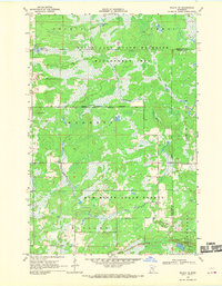 1968 Milaca NE1970 Print · USGSMille Lacs and Kanabec counties are shown in the late sixties as a network of conservation lands and rural outposts. Researchers can trace the locations of the North Fork Sch, the Mille Lacs Lookout Tower, and a local Townhall.
 - 1968 Map of Onamia, 1970 Print
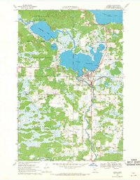 1968 Onamia1970 Print · USGSThe southern shore of Mille Lacs Lake comes into focus during the late 1960s, showing the intersection of industry, faith, and conservation. Genealogists and local historians can trace the foundations of Onamia through the Crosier Seminary, Holy Cross Church, and several local cemeteries.2 unique versions available
 - 1968 Map of Page, 1970 Print
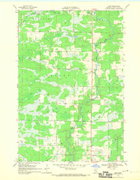 1968 Page1970 Print · USGSThe Rum River valley in the late sixties reveals a quiet landscape of riverside settlements and managed timberlands. Genealogists and local researchers can trace family lands near Page or locate the old Gravel Pits and Wayside Park along the river's winding path.2 unique versions available
 - 1968 Map of Wahkon South, 1970 Print
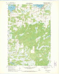 1968 Wahkon South1970 Print · USGSThe southern shores of Mille Lacs Lake are captured here in the late sixties, showing the lakeside communities of Wahkon and Bayview alongside vast conservation lands. Researchers can trace local landmarks like Foster Cem, the Camp Johnson Sch, and the path of the Soo Line.
End of results
Showing maps 1-5 of 5
Top cities near Onamia Township
Frequently asked questions
- What are the different types of historical maps available for Onamia Township?
- What is the oldest map of Onamia Township?
- Where can I purchase historical maps of Onamia Township for my home or office?
- Where can I download high-res historical maps of Onamia Township?
- Are there historical topographic maps available for Onamia Township?
- Is there historical aerial imagery available for Onamia Township?
- Where are historical maps of Onamia Township sourced from?