1970s Maps of Stewartville, Minnesota
Explore 4 historic maps of Stewartville from the 1970s. These maps offer a rare glimpse into what life looked like during the 1970s — showing old roads, neighborhoods, homes, and landmarks that have changed or disappeared over time.
Whether you're researching your family's past, planning a metal detecting trip, or studying how Stewartville's landscape evolved across the 1970s, these high-resolution maps are a powerful tool for exploring the history of this region.
- Focus on a specific era: All maps on this page are from the 1970s, giving you a focused view of this time period.
- See what’s changed: Compare century-old streets, trails, and buildings to today's modern landscape using overlays and satellite layers.
- Research with precision: Use these maps for genealogy, historical research, land use analysis, or educational projects.
- View, download, or print: Maps are fully viewable online in high resolution, and can be downloaded or printed for your own records.
Start exploring Stewartville's history through authentic maps from the 1970s. This is your window into the past.
Stewartville, MN maps
(4)- 1974 Map of High Forest, 1976 Print
 1974 High Forest1976 Print · USGSHigh Forest and the surrounding townships of Olmsted and Mower counties are shown here during the mid-seventies. Genealogists can trace family landmarks like the Pleasant Valley Ch and St Johns Cem, while tracing the course of the North Branch Root River.
 - 1974 Map of Salem Corners, 1976 Print
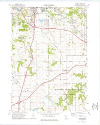
 1974 Salem Corners1976 Print · USGSWestern Olmsted County appears here in the mid-seventies, showing a landscape of river valleys and growing municipal infrastructure. Genealogists and local historians can locate Riverside Cem, the Bamber Valley Sch, and the Rochester Municipal Airport.2 unique versions available
 - 1974 Map of Stewartville, 1976 Print
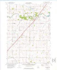
 1974 Stewartville1976 Print · USGSStewartville and the surrounding townships are documented in the mid-seventies, showing the intersection of heavy industry and small-town life. Genealogists and historians can trace the Chicago and North Western corridor and locate St Bernard Cem or Sumner Center Ch.
 - 1974 Map of Simpson, 1976 Print
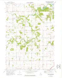
 1974 Simpson1976 Print · USGSOlmsted County reveals a mix of mid-century suburban expansion and deep-rooted rural life during the 1970s. Trace the development of Rochester alongside historic local landmarks like St Bridget Ch and the Fugles Mill Historical Site.2 unique versions available
End of results
Showing maps 1-4 of 4
Top cities near Stewartville
- Rochester historical maps
- Marion historical maps
- Kasson historical maps
- Byron historical maps
- Spring Valley historical maps
- High Forest historical maps
See more
Frequently asked questions
- What are the different types of historical maps available for Stewartville?
- What is the oldest map of Stewartville?
- Where can I purchase historical maps of Stewartville for my home or office?
- Where can I download high-res historical maps of Stewartville?
- Are there historical topographic maps available for Stewartville?
- Is there historical aerial imagery available for Stewartville?
- Where are historical maps of Stewartville sourced from?