1960s Maps of Richmond, Minnesota
Explore 2 historic maps of Richmond from the 1960s. These maps offer a rare glimpse into what life looked like during the 1960s — showing old roads, neighborhoods, homes, and landmarks that have changed or disappeared over time.
Whether you're researching your family's past, planning a metal detecting trip, or studying how Richmond's landscape evolved across the 1960s, these high-resolution maps are a powerful tool for exploring the history of this region.
- Focus on a specific era: All maps on this page are from the 1960s, giving you a focused view of this time period.
- See what’s changed: Compare century-old streets, trails, and buildings to today's modern landscape using overlays and satellite layers.
- Research with precision: Use these maps for genealogy, historical research, land use analysis, or educational projects.
- View, download, or print: Maps are fully viewable online in high resolution, and can be downloaded or printed for your own records.
Start exploring Richmond's history through authentic maps from the 1960s. This is your window into the past.
Richmond, MN maps
(2)- 1967 Map of Cold Spring, 1963 Print
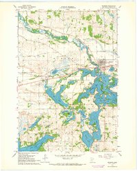
 1967 Cold Spring1963 Print · USGSThe Sauk River valley and its complex chain of lakes are captured here in the late sixties. Genealogists and local researchers can trace family landmarks like St Boniface Cem, Assumption Chapel, and the rural School No 1926 near St Nicholas.2 unique versions available
 - 1967 Map of Richmond, 1968 Print
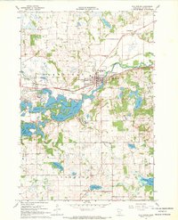
 1967 Richmond1968 Print · USGSStearns County lake country is captured here in the late sixties, centering on the interconnected waters of the Sauk River valley. Genealogists and historians can trace the Great Northern tracks through Richmond and locate landmarks like the local Cem and the village of Roscoe.2 unique versions available
End of results
Showing maps 1-2 of 2
Top cities near Richmond
- Saint Joseph historical maps
- Cold Spring historical maps
- Rockville historical maps
- Paynesville historical maps
- Albany historical maps
- Avon historical maps
See more
Frequently asked questions
- What are the different types of historical maps available for Richmond?
- What is the oldest map of Richmond?
- Where can I purchase historical maps of Richmond for my home or office?
- Where can I download high-res historical maps of Richmond?
- Are there historical topographic maps available for Richmond?
- Is there historical aerial imagery available for Richmond?
- Where are historical maps of Richmond sourced from?