Old Maps of Wabasha, Minnesota
Explore 15 old maps of Wabasha, spanning from 1932 to today. These high-resolution historic maps reveal how streets, neighborhoods, landmarks, and natural features evolved over time — perfect for genealogy, metal detecting, research, and local history exploration.
What you can do with these maps:
- See how Wabasha changed over time: Compare historical maps to modern-day views to trace roads, homesites, rail lines & more.
- View detailed metadata: Each map includes creators, publishers, year, scale, and archive source.
- Overlay maps with satellite & LiDAR: Visualize the past alongside modern tools to explore terrain & human change.
- Trusted historical sources: Maps sourced from the USGS, Library of Congress, and other archives.
- Access maps your way: View online, download high-res files, or order prints for personal or research use.
Start exploring old maps of Wabasha to uncover forgotten places, hidden landmarks, and the deep history beneath your feet.
Wabasha, MN maps
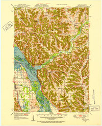
(15)- 1932 Map of Wabasha
 1932 Wabasha1932 Print · USGSCovers Wabasha, including Lake City, Pepin, and other nearby areas2 unique versions available
 - 1932 Map of Alma
 1932 Alma1932 Print · USGSCovers Wabasha, including Alma, Waumandee, and other nearby areas2 unique versions available
 - 1950 Map of Alma, 1952 Print
 1950 Alma1952 Print · USGSCovers Wabasha, including Alma, Waumandee, and other nearby areas8 unique versions available
 - 1951 Map of Wabasha
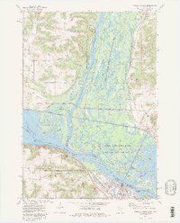
 1951 Wabasha1951 Print · USGSCovers Wabasha, including Lake City, Pepin, and other nearby areas3 unique versions available
 - 1953 Map of Saint Paul, 1964 Print
 1953 Saint Paul1964 Print · USGSCovers Wabasha, including Minneapolis, Saint Paul, and other nearby areas4 unique versions available
 - 1953 Map of Eau Claire, 1965 Print
 1953 Eau Claire1965 Print · USGSCovers Wabasha, including Eau Claire, Winona, and other nearby areas4 unique versions available
 - 1958 Map of Eau Claire
 1958 Eau Claire1958 Print · USGSCovers Wabasha, including Eau Claire, Winona, and other nearby areas
 - 1959 Map of Saint Paul
 1959 Saint Paul1959 Print · USGSCovers Wabasha, including Minneapolis, Saint Paul, and other nearby areas2 unique versions available
 - 1964 Map of Eau Claire
 1964 Eau Claire1964 Print · USGSCovers Wabasha, including Eau Claire, Winona, and other nearby areas
 - 1974 Map of Wabasha South, 1976 Print
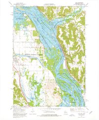
 1974 Wabasha South1976 Print · USGSCovers Wabasha, including Kellogg, Conception, and other nearby areas
 - 1974 Map of Wabasha North, 1976 Print
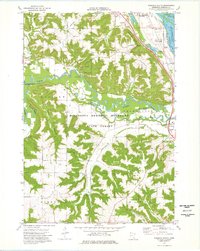
 1974 Wabasha North1976 Print · USGSCovers Wabasha, including Nelson, Camp Lacupolis, and other nearby areas2 unique versions available
 - 1974 Map of Alma, 1976 Print
 1974 Alma1976 Print · USGSCovers Wabasha, including Alma, Kellogg, and other nearby areas2 unique versions available
 - 1985 Map of Rochester
 1985 Rochester1985 Print · USGSCovers Wabasha, including Rochester, Kasson, and other nearby areas
 - 1985 Map of Winona
 1985 Winona1985 Print · USGSCovers Wabasha, including Winona, Holmen, and other nearby areas2 unique versions available
 - 1989 Map of Rochester
 1989 Rochester1989 Print · USGSCovers Wabasha, including Rochester, Kasson, and other nearby areas2 unique versions available
End of results
Showing maps 1-15 of 15
Top cities near Wabasha
- Lake City historical maps
- Plainview historical maps
- Buffalo City historical maps
- Pepin historical maps
- Alma historical maps
- Lima historical maps
See more
Frequently asked questions
- What are the different types of historical maps available for Wabasha?
- What is the oldest map of Wabasha?
- Where can I purchase historical maps of Wabasha for my home or office?
- Where can I download high-res historical maps of Wabasha?
- Are there historical topographic maps available for Wabasha?
- Is there historical aerial imagery available for Wabasha?
- Where are historical maps of Wabasha sourced from?