1980s Maps of Woodland Township, Minnesota
Explore 8 historic maps of Woodland Township from the 1980s. These maps offer a rare glimpse into what life looked like during the 1980s — showing old roads, neighborhoods, homes, and landmarks that have changed or disappeared over time.
Whether you're researching your family's past, planning a metal detecting trip, or studying how Woodland Township's landscape evolved across the 1980s, these high-resolution maps are a powerful tool for exploring the history of this region.
- Focus on a specific era: All maps on this page are from the 1980s, giving you a focused view of this time period.
- See what’s changed: Compare century-old streets, trails, and buildings to today's modern landscape using overlays and satellite layers.
- Research with precision: Use these maps for genealogy, historical research, land use analysis, or educational projects.
- View, download, or print: Maps are fully viewable online in high resolution, and can be downloaded or printed for your own records.
Start exploring Woodland Township's history through authentic maps from the 1980s. This is your window into the past.
Woodland Township, MN maps
(8)- 1981 Map of Mayer
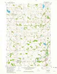 1981 Mayer1981 Print · USGSCarver and Wright counties are shown here in the early eighties as a landscape of established rail corridors and river-bound townships. Genealogists and local historians can locate St Mark Cem, trace the Burlington Northern line, and find the Ziermann Landing Strip near Mayer.
 - 1981 Map of Waverly, 1982 Print
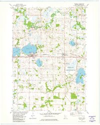 1981 Waverly1982 Print · USGSWright County is captured here in the early 1980s as its agricultural roots and railway corridors remained central to local life. Genealogists and local historians can locate several parish landmarks and cemeteries, including Swedesburg Ch, Mission Cem, and Wright Cem.
 - 1982 Map of Howard Lake
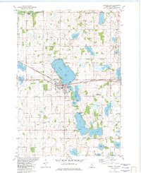 1982 Howard Lake1982 Print · USGSWright County in the early eighties centers on the lakeside town of Howard Lake and its vital Burlington Northern rail link. Local historians can trace family roots at Reinmuth Cem and St James Cem or explore the rural landscape of Victor Twp.
 - 1982 Map of Winsted, 1983 Print
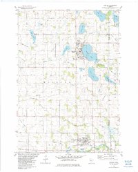 1982 Winsted1983 Print · USGSDuring the early 1980s, this area of McLeod and Wright counties maintained its strong rural identity along the Crow River South Fork. Genealogists and local historians can trace family roots through Holy Trinity Cem, Swedish Cem, and the old rail corridor of the Luce Line State Recreational Trail.
 - 1985 Map of Saint Paul
 1985 Saint Paul1985 Print · USGSThe Twin Cities metropolitan area and its southern suburbs are captured here in the mid-eighties as the urban landscape expanded toward the Minnesota River. Researchers can trace the layout of the Fort Snelling Military Reservation, find local landmarks like St Benedict Church, and study the rail routes of the Soo Line.2 unique versions available
 - 1985 Map of Anoka
 1985 Anoka1985 Print · USGSThe northern Twin Cities suburbs and the Mississippi River valley are captured here in the mid-eighties as suburban growth began to meet rural conservation lands. Trace the expansion of Anoka and Blaine, or locate family landmarks near the Rum River and Buffalo Lake.
 - 1986 Map of Litchfield
 1986 Litchfield1986 Print · USGSCentral Minnesota in the mid-eighties was a landscape of conservation and transport, where the Burlington Northern rail line connected thriving lake towns. Genealogists and historians can trace old townships and landmarks like St Nicholas, Forest City, and School House Lake.2 unique versions available
 - 1986 Map of Glencoe
 1986 Glencoe1986 Print · USGSThe south-central Minnesota prairie and its glacial lake basins are captured here in the mid-1980s, showcasing a landscape of intensive farming and conservation. Genealogists can locate family-named landmarks and trace the rail lines of the Soo Line and Chicago and North Western through towns like Gaylord, Olivia, and Hutchinson.2 unique versions available
End of results
Showing maps 1-8 of 8
Top cities near Woodland Township
- St. Michael historical maps
- Buffalo historical maps
- Waconia historical maps
- Minnetrista historical maps
- Delano historical maps
- Watertown historical maps
See more
Top neighborhoods of Woodland Township
Frequently asked questions
- What are the different types of historical maps available for Woodland Township?
- What is the oldest map of Woodland Township?
- Where can I purchase historical maps of Woodland Township for my home or office?
- Where can I download high-res historical maps of Woodland Township?
- Are there historical topographic maps available for Woodland Township?
- Is there historical aerial imagery available for Woodland Township?
- Where are historical maps of Woodland Township sourced from?