1960s Maps of Pierces Chapel, Mississippi
Explore 3 historic maps of Pierces Chapel from the 1960s. These maps offer a rare glimpse into what life looked like during the 1960s — showing old roads, neighborhoods, homes, and landmarks that have changed or disappeared over time.
Whether you're researching your family's past, planning a metal detecting trip, or studying how Pierces Chapel's landscape evolved across the 1960s, these high-resolution maps are a powerful tool for exploring the history of this region.
- Focus on a specific era: All maps on this page are from the 1960s, giving you a focused view of this time period.
- See what’s changed: Compare century-old streets, trails, and buildings to today's modern landscape using overlays and satellite layers.
- Research with precision: Use these maps for genealogy, historical research, land use analysis, or educational projects.
- View, download, or print: Maps are fully viewable online in high resolution, and can be downloaded or printed for your own records.
Start exploring Pierces Chapel's history through authentic maps from the 1960s. This is your window into the past.
Pierces Chapel, MS maps
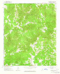
(3)- 1963 Map of West Point
 1963 West Point1963 Print · USGSEastern Mississippi and western Alabama are captured in the early sixties as industrial centers and rail lines connected the Black Prairie to the hills. Genealogists and historians can trace family-named watercourses and the early footprints of Starkville, Columbus, and the Noxubee National Wildlife Refuge.2 unique versions available
 - 1964 Map of Kosciusko NE, 1965 Print
 1964 Kosciusko NE1965 Print · USGSAttala County is shown in the mid-1960s as a landscape of interconnected creek valleys and small community hubs. Researchers can trace family history through numerous landmarks like New Salem Cem, Oak Ridge Ch, and the Sandpit.3 unique versions available
 - 1966 Map of Kosciusko, 1967 Print
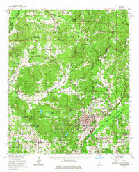 1966 Kosciusko1967 Print · USGSCentral Mississippi in the mid-sixties centers on Kosciusko and its surrounding rural communities. Genealogists can trace family names through dozens of landmarks like Carmack Sch, Hesterville, and the Bethlehem Cem.
End of results
Showing maps 1-3 of 3
Top cities near Pierces Chapel
- Kosciusko historical maps
- Vaiden historical maps
- Ethel historical maps
- French Camp historical maps
- West historical maps
- McCool historical maps
See more
Frequently asked questions
- What are the different types of historical maps available for Pierces Chapel?
- What is the oldest map of Pierces Chapel?
- Where can I purchase historical maps of Pierces Chapel for my home or office?
- Where can I download high-res historical maps of Pierces Chapel?
- Are there historical topographic maps available for Pierces Chapel?
- Is there historical aerial imagery available for Pierces Chapel?
- Where are historical maps of Pierces Chapel sourced from?