1900s (20th Century) Maps of Whaley, Mississippi
Explore 8 historic maps of Whaley from the 1900s (20th Century). These maps offer a rare glimpse into what life looked like during the 1900s — showing old roads, neighborhoods, homes, and landmarks that have changed or disappeared over time.
Whether you're researching your family's past, planning a metal detecting trip, or studying how Whaley's landscape evolved across the 1900s, these high-resolution maps are a powerful tool for exploring the history of this region.
- Focus on a specific era: All maps on this page are from the 1900s, giving you a focused view of this time period.
- See what’s changed: Compare century-old streets, trails, and buildings to today's modern landscape using overlays and satellite layers.
- Research with precision: Use these maps for genealogy, historical research, land use analysis, or educational projects.
- View, download, or print: Maps are fully viewable online in high resolution, and can be downloaded or printed for your own records.
Start exploring Whaley's history through authentic maps from the 1900s. This is your window into the past.
Whaley, MS maps
(8)- 1936 Map of Greenwood
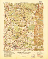
 1936 Greenwood1936 Print · USGSThe Mississippi Delta's river-driven economy is on full display in the mid-1930s as the forks of the Yazoo converge at Greenwood. Genealogists and historians can locate rural landmarks like Geren PO, Little Zion Ch, and the Rosenwald Sch among the oxbows of Tippo Bayou.2 unique versions available
 - 1940 Map of Greenwood, 1945 Print
 1940 Greenwood1945 Print · USGSThe Mississippi Delta's river-and-rail economy is in full view at the start of the 1940s, where the Yazoo River begins. Genealogists and historians can trace rural communities through the Rosenwald Sch, Ruby Sta, and the historic Malmaison estate.
 - 1953 Map of Greenwood, 1966 Print
 1953 Greenwood1966 Print · USGSThe Mississippi Delta in the mid-fifties is captured here as a thriving network of river towns, railroads, and oxbow lakes. Researchers can trace the legacy of the Illinois Central Railroad and locate landmarks like the State Penal Farm and Greenville Air Force Base.5 unique versions available
 - 1956 Map of Greenwood
 1956 Greenwood1956 Print · USGSThe Mississippi Delta in the mid-fifties is captured here during a period of significant military and agricultural activity. Researchers can trace the rail lines of the Illinois Central RR, find the Greenville Air Force Base, or locate the State Penal Farm.
 - 1957 Map of Greenwood
 1957 Greenwood1957 Print · USGSThe Mississippi Delta in the late fifties shows a landscape of river-bend settlements and extensive rail networks. Genealogists can trace family roots at Little Zion Ch & Cem, Money, and the many rural churches like Lanes Chapel or Evergreen Ch.3 unique versions available
 - 1974 Map of Greenwood SE, 1975 Print
 1974 Greenwood SE1975 Print · USGSIn the mid-1970s, the Carroll County landscape was defined by the sharp transition between the Delta bottomlands and the bluffs. Researchers can trace the layout of the settlement at Browning and study the intricate field patterns and woodland boundaries of the era.
 - 1982 Map of Browning
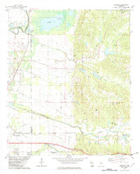 1982 Browning1982 Print · USGSThe Carroll County hills meet the Delta in the early 1980s, revealing a landscape of family cemeteries and historic Choctaw-linked sites. Genealogists can trace family names at the Greenwood LeFlore Cem or locate rural landmarks like Malmaison and Mitchell Springs Ch.
 - 1983 Map of Greenwood
 1983 Greenwood1983 Print · USGSThe Mississippi Delta in the early eighties shows a landscape of rail-connected towns and vast river systems. Genealogists and historians can trace family roots in towns like Mound Bayou, Ruleville, and the grounds of Mississippi Valley State University.
End of results
Showing maps 1-8 of 8
Top cities near Whaley
- Greenwood historical maps
- Itta Bena historical maps
- Sidon historical maps
- North Carrollton historical maps
- Carrollton historical maps
- Glendora historical maps
Frequently asked questions
- What are the different types of historical maps available for Whaley?
- What is the oldest map of Whaley?
- Where can I purchase historical maps of Whaley for my home or office?
- Where can I download high-res historical maps of Whaley?
- Are there historical topographic maps available for Whaley?
- Is there historical aerial imagery available for Whaley?
- Where are historical maps of Whaley sourced from?