1970s Maps of Mount Olive, Mississippi
Explore 2 historic maps of Mount Olive from the 1970s. These maps offer a rare glimpse into what life looked like during the 1970s — showing old roads, neighborhoods, homes, and landmarks that have changed or disappeared over time.
Whether you're researching your family's past, planning a metal detecting trip, or studying how Mount Olive's landscape evolved across the 1970s, these high-resolution maps are a powerful tool for exploring the history of this region.
- Focus on a specific era: All maps on this page are from the 1970s, giving you a focused view of this time period.
- See what’s changed: Compare century-old streets, trails, and buildings to today's modern landscape using overlays and satellite layers.
- Research with precision: Use these maps for genealogy, historical research, land use analysis, or educational projects.
- View, download, or print: Maps are fully viewable online in high resolution, and can be downloaded or printed for your own records.
Start exploring Mount Olive's history through authentic maps from the 1970s. This is your window into the past.
Mount Olive, MS maps
(2)- 1974 Map of Lone Star, 1978 Print
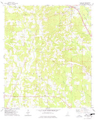 1974 Lone Star1978 Print · USGSCovington County's rural landscape is captured here in the mid-seventies, showing the steady growth of Mount Olive along the Illinois Central Gulf rail line. Researchers can trace family sites at the Lone Star Cem, the County Foundation Sch, and Friendship Ch.2 unique versions available
 - 1975 Map of Magee South, 1978 Print
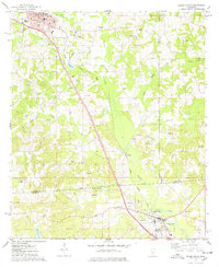 1975 Magee South1978 Print · USGSSettlement along the Illinois Central Gulf rail line in Simpson County is captured here in the mid-seventies. Genealogists and historians can trace family sites at Ware Cem and McNair Cem or locate the historic Old Indian Treaty Boundary.
End of results
Showing maps 1-2 of 2
Top cities near Mount Olive
- Magee historical maps
- Collins historical maps
- Mendenhall historical maps
- Taylorsville historical maps
- Prentiss historical maps
- Seminary historical maps
See more
Frequently asked questions
- What are the different types of historical maps available for Mount Olive?
- What is the oldest map of Mount Olive?
- Where can I purchase historical maps of Mount Olive for my home or office?
- Where can I download high-res historical maps of Mount Olive?
- Are there historical topographic maps available for Mount Olive?
- Is there historical aerial imagery available for Mount Olive?
- Where are historical maps of Mount Olive sourced from?