1980s Maps of Hernando, Mississippi
Explore 6 historic maps of Hernando from the 1980s. These maps offer a rare glimpse into what life looked like during the 1980s — showing old roads, neighborhoods, homes, and landmarks that have changed or disappeared over time.
Whether you're researching your family's past, planning a metal detecting trip, or studying how Hernando's landscape evolved across the 1980s, these high-resolution maps are a powerful tool for exploring the history of this region.
- Focus on a specific era: All maps on this page are from the 1980s, giving you a focused view of this time period.
- See what’s changed: Compare century-old streets, trails, and buildings to today's modern landscape using overlays and satellite layers.
- Research with precision: Use these maps for genealogy, historical research, land use analysis, or educational projects.
- View, download, or print: Maps are fully viewable online in high resolution, and can be downloaded or printed for your own records.
Start exploring Hernando's history through authentic maps from the 1980s. This is your window into the past.
Hernando, MS maps
(6)- 1982 Map of Pleasant Hill
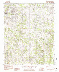 1982 Pleasant Hill1982 Print · USGSDeSoto County and Shelby County meet in the early 1980s as suburban expansion reaches southward across the state line. Genealogists and local historians can trace the development of Southaven or locate the rural Pleasant Hill community and Sunrise Lake.
 - 1982 Map of Horn Lake
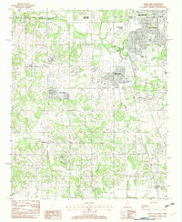 1982 Horn Lake1982 Print · USGSNorthwestern Mississippi was undergoing a period of suburban expansion in the early eighties as the outskirts of the Delta met the growing reach of the city. Researchers can trace the development of Southaven and Horn Lake or locate rural sites like Nesbit and Deans Corner.
 - 1982 Map of Frees Corners
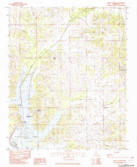 1982 Frees Corners1982 Print · USGSDeSoto County's reservoir landscape is captured here in the early 1980s, centered on the northern reaches of the Arkabutla Lake. Local historians can trace rural settlements like Frees Corners, Pleasant Hill, and the outlying edges of Hernando.2 unique versions available
 - 1982 Map of Hernando
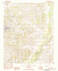 1982 Hernando1982 Print · USGSNorthern Mississippi's landscape in the early eighties centers on the growth of Hernando and the surrounding rural communities. Genealogists and researchers can trace local landmarks and waterways from Bright to Love, including the shores of Arkabutla Lake.2 unique versions available
 - 1984 Map of Tupelo
 1984 Tupelo1984 Print · USGSNorth Mississippi in the 1980s is defined by its massive river basin reservoirs and the growing regional hubs of Tupelo and Oxford. Researchers can trace the legacy of the Pontotoc Ridge, find the University of Mississippi, and map early Interstate corridors near Sardis Lake.3 unique versions available
 - 1984 Map of Helena, 1985 Print
 1984 Helena1985 Print · USGSThe Delta landscape of Arkansas and Mississippi comes to life in this mid-eighties survey of river bends and ridge settlements. Researchers can trace the rail-and-river economy through Missouri Pacific lines and local landmarks like Whiskey Island or Marianna.
End of results
Showing maps 1-6 of 6
Top cities near Hernando
- Memphis historical maps
- Southaven historical maps
- Germantown historical maps
- Olive Branch historical maps
- Horn Lake historical maps
- Senatobia historical maps
See more
Top neighborhoods of Hernando
Frequently asked questions
- What are the different types of historical maps available for Hernando?
- What is the oldest map of Hernando?
- Where can I purchase historical maps of Hernando for my home or office?
- Where can I download high-res historical maps of Hernando?
- Are there historical topographic maps available for Hernando?
- Is there historical aerial imagery available for Hernando?
- Where are historical maps of Hernando sourced from?