1990s Maps of Kirkwood Park, Hattiesburg
Explore 2 historic maps of Kirkwood Park from the 1990s. These maps offer a rare glimpse into what life looked like during the 1990s — showing old roads, neighborhoods, homes, and landmarks that have changed or disappeared over time.
Whether you're researching your family's past, planning a metal detecting trip, or studying how Kirkwood Park's landscape evolved across the 1990s, these high-resolution maps are a powerful tool for exploring the history of this region.
- Focus on a specific era: All maps on this page are from the 1990s, giving you a focused view of this time period.
- See what’s changed: Compare century-old streets, trails, and buildings to today's modern landscape using overlays and satellite layers.
- Research with precision: Use these maps for genealogy, historical research, land use analysis, or educational projects.
- View, download, or print: Maps are fully viewable online in high resolution, and can be downloaded or printed for your own records.
Start exploring Kirkwood Park's history through authentic maps from the 1990s. This is your window into the past.
Kirkwood Park, Hattiesburg maps
(2)- 1994 Map of Hattiesburg, 1995 Print
 1994 Hattiesburg1995 Print · USGSSouth-central Mississippi's river valleys and timberlands are seen here in the mid-1990s as the region's transport network matured. Researchers can trace rural lineages through sites like Old Pioneer Cem and Spring Cottage or explore the vast Camp Shelby Military Reservation.
 - 1996 Map of Hattiesburg, 2000 Print
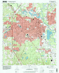 1996 Hattiesburg2000 Print · USGSHattiesburg and the neighboring community of Petal are shown in the mid-nineties during a period of steady institutional and suburban growth. Researchers can locate family landmarks like B'nai Israel Cem, trace the Illinois Central Gulf RR, or study the University of Southern Mississippi campus.
End of results
Showing maps 1-2 of 2
Frequently asked questions
- What are the different types of historical maps available for Kirkwood Park?
- What is the oldest map of Kirkwood Park?
- Where can I purchase historical maps of Kirkwood Park for my home or office?
- Where can I download high-res historical maps of Kirkwood Park?
- Are there historical topographic maps available for Kirkwood Park?
- Is there historical aerial imagery available for Kirkwood Park?
- Where are historical maps of Kirkwood Park sourced from?